
Showers Developing Late Today Overnight
Rain Exits Monday Morning
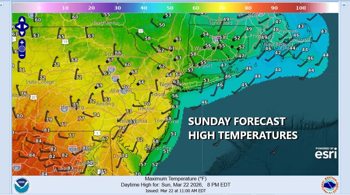
We continue to be in a weather pattern dominated by a west northwest flow in the upper atmosphere. This pattern is bringing weather fronts through every couple of days. This limits warm ups but it also shortens any chill downs with cold air. With that in mind another cold front approaches today and we will see increasing clouds with some showers developing late this afternoon. Temperatures today will range from the low 70s across Southern New Jersey and Southern Pennsylvania to the 60s in Northern New Jersey to Southern New England. Temperatures will be cooler along coastal areas with winds coming from the south and southwest
SATELLITE WITH LIGHTNING STRIKES

WEATHER RADAR

Radars are picking up on showers and even a few thunderstorms across Upstate New York. We will be getting into showery rains overnight. The front passes and stalls to the south and a wave develops in Maryland overnight and moves out to the east. That should push the cold front far enough offshore so that the rain comes to an end in most of the area before daybreak.

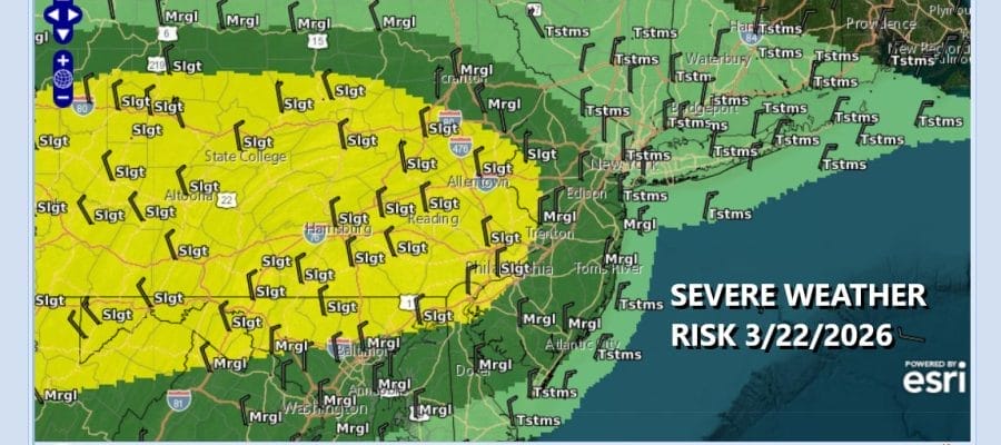
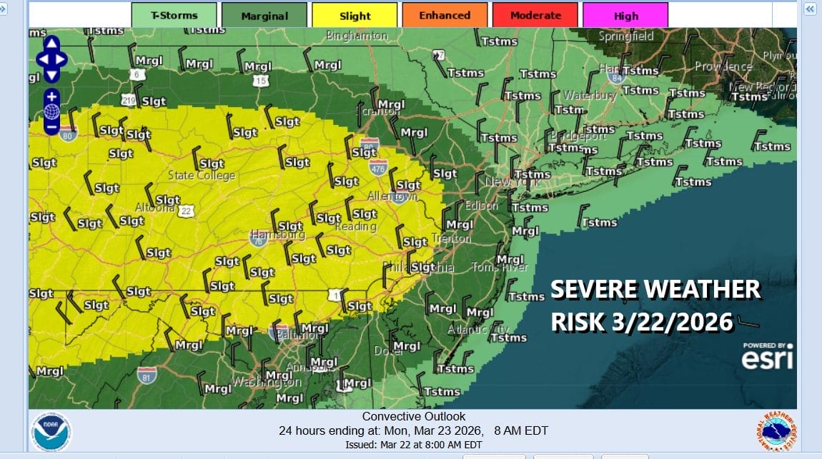
There could be a few thunderstorms in the mix and the Storm Prediction Center is indicating that there could be some risk for severe thunderstorms developing with this cold front. There is a marginal risk for isolated severe thunderstorms in New Jersey and a slight risk across some Western New Jersey counties and much of Pennsylvania. There is also risks for isolated tornadoes.
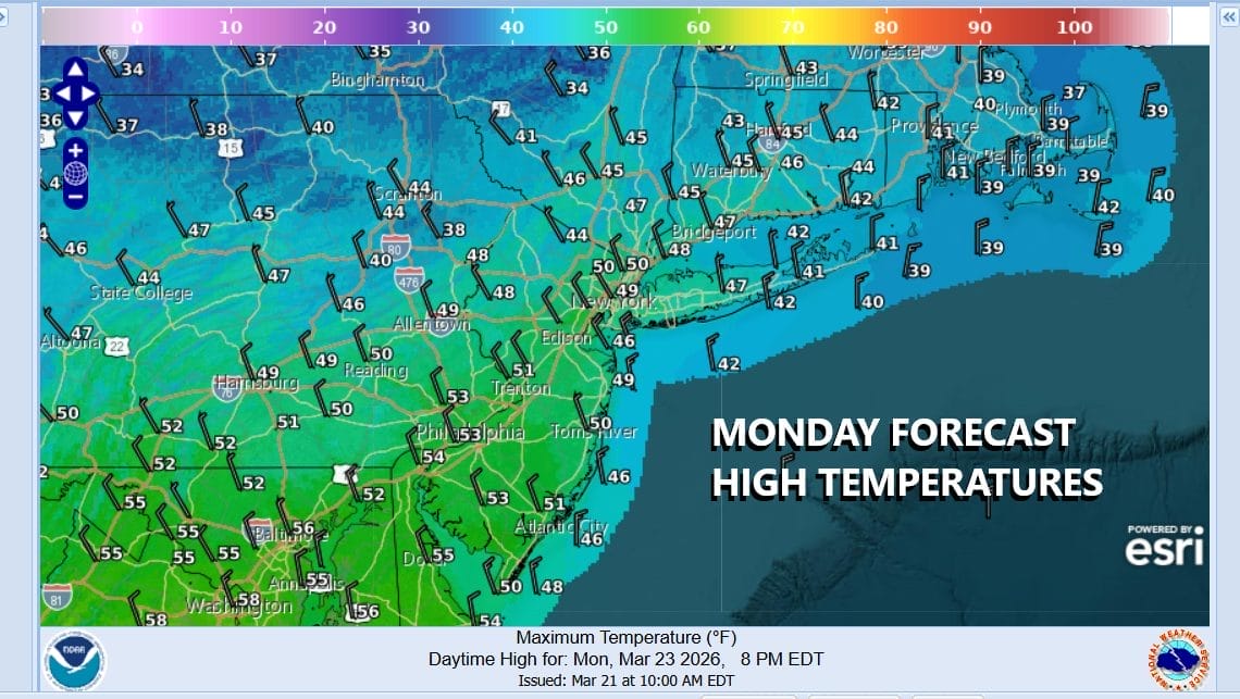
All of this will be gone Monday and weather conditions will improve but it will also be turning colder. Gusty northwest winds develop and we will see decreasing clouds with increasing sunshine. Temperatures likely will reach their highs early in the day and we will settle in the 50s for much of Monday before temperatures drop off Monday night into Tuesday morning.
Tuesday morning lows will be in the mid 20s to lower 30s from inland to the coast. Tuesday will be a sunny chilly day as the core of the cold air mass moves overhead. Tuesday highs will be in the 40s. Wednesday we will see moderating temperatures into the 50s followed by another cold front with a few showers Wednesday night into Thursday morning. Thursday looks dry but that will be followed by another cold front and another round of showers Friday to finish off the work week.
BE SURE TO DOWNLOAD THE FREE METEOROLOGIST JOE CIOFFI WEATHER APP &
ANGRY BEN’S FREE WEATHER APP “THE ANGRY WEATHERMAN!
MANY THANKS TO TROPICAL TIDBITS FOR THE USE OF MAPS
Please note that with regards to any severe weather, tropical storms, or hurricanes, should a storm be threatening, please consult your local National Weather Service office or your local government officials about what action you should be taking to protect life and property.


