
Severe Weather Risks Mostly in New England Today
As Weather Front Moves Through

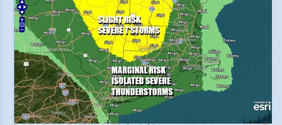
A cold front is moving quickly through the Mid Atlantic and Northeast and that has resulted in the risk for severe thunderstorms today to shift northward into Southern New England, Long Island to New York City, Northern New Jersey and points north and northeastward into New England. The highest area is in the Upper Hudson Valley in New York as well as Western Massachusetts, Vermont and Western New Hampshire.

Satellite and radar loops show a weather front is moving across Pennsylvania and New York with a sharp clearing line. Once we get through this morning into midday when there is the risk for a shower or thunderstorm especially to the north of NYC, weather conditions should improve and we will see developing sunshine from west to east. It will be a warm afternoon with highs in the upper 70s and lower 80s. Dew points will be dropping as dry air arrives on northwest winds.
SATELLITE WITH LIGHTNING STRIKES

WEATHER RADAR

Tonight skies should at least be partially clear with most lows in the mid 50s to around 60 in the warmest urban locations. Low pressure in the Gulf of Maine Sunday rotates around for awhile and this going to create cold and unstable conditions aloft in the Northeast and Northern Mid Atlantic states. Eventually the low moves away to the northeast Sunday night and Monday creating a more stable atmosphere .

Sunday dayside will be a day of a mix of sun and clouds. The cold unstable air and the normal daytime heating will likely create some developing clouds especially inland and we can’t rule out the possibility of a scattered shower or two. Most highs Sunday will be in the upper 60s north and low to mid 70s south along with a gusty northwest wind.

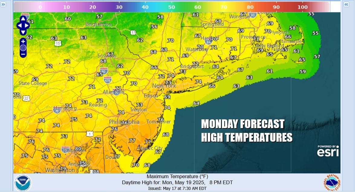
Monday and Tuesday will be dry days with no worse than partly sunny skies for Monday. Tuesday will see sunshine to start the day before clouds start to arrive from the west and south west. We will see slightly cooler than average temperatures for Monday with highs reaching the the low and middle 70s except perhaps a little cooler along south and east facing shorelines.
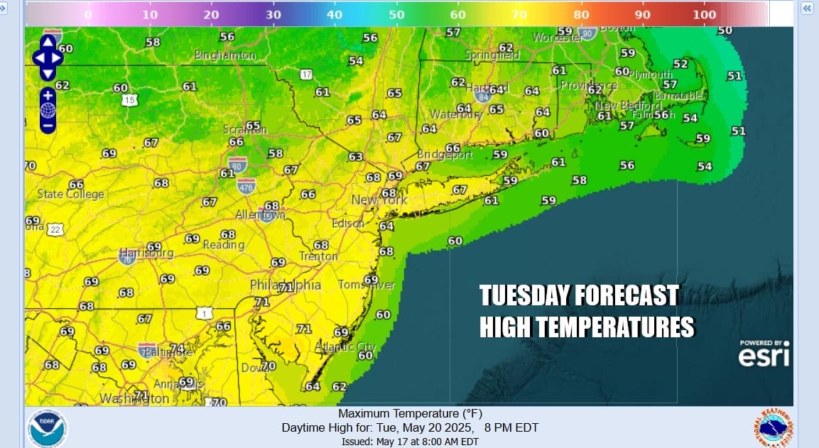
Tuesday highs will be in the upper 60s and lower 70s thanks to winds going more easterly. High pressure is going to building across Southeastern Canada and New England and low pressure developing in the Plains Sunday starts to head east northeastward through the Tennessee and Ohio Valley Monday and Tuesday. Rain will not be an issue through the daytime Tuesday.
This complex low coming out of the Plains will eventually head to the Ohio or Western Pennsylvania and then redevelop off the Delaware and New Jersey coasts later Wednesday into Thursday. This is going to create some raw and somewhat windy weather with northeast winds, rain that will be overspreading the region Wednesday, and temperatures that both Wednesday and Thursday do not get much out of the 50s. While the bulk of the rain with this system will be Wednesday into Thursday, it leaves us with a low to the north hanging around through at least next Sunday. Shower risks will be included in the forecast for Friday, Saturday and Sunday, but for now we may leave them out of the forecast for Memorial Day. It won’t be raining all the time and there will be periods of mix sun and clouds. However we will see temperatures cooler than average and not exactly beach weather for the Memorial Day holiday weekend.
BE SURE TO DOWNLOAD THE FREE METEOROLOGIST JOE CIOFFI WEATHER APP &
ANGRY BEN’S FREE WEATHER APP “THE ANGRY WEATHERMAN!
MANY THANKS TO TROPICAL TIDBITS FOR THE USE OF MAPS
Please note that with regards to any severe weather, tropical storms, or hurricanes, should a storm be threatening, please consult your local National Weather Service office or your local government officials about what action you should be taking to protect life and property.


