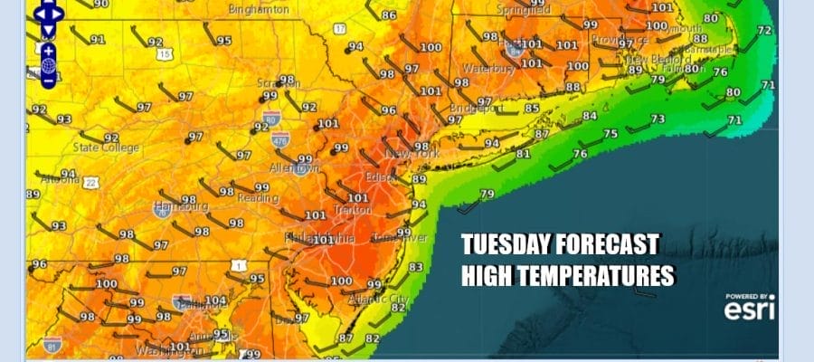

Record Highs Near 100 Degrees For A Second Day
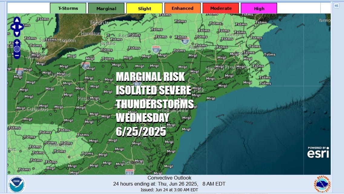
Severe Weather Risks Later Wednesday
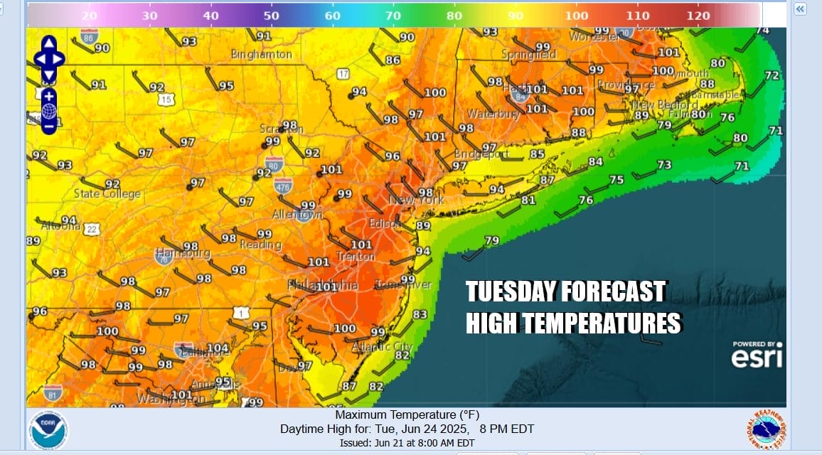
Today is the second day of very hot, very humid weather and it will be another day of record highs. We are seeing high pressure stationary over the the Middle Atlantic states. A mostly west wind and sunshine will send temperatures climbing once again to the upper 90s to lower 100s. We will throw in a tiny chance for an isolated severe thunderstorm late this afternoon and evening but we are talking an extremely low chance. This will also be the last super hot day of this current stretch of summer weather as changes get underway tonight and Wednesday.
SATELLITE WITH LIGHTNING STRIKES

WEATHER RADAR

Another steamy night lies ahead with nothing more than some passing clouds. Overnight lows will be in the mid 70s to lower 80s Wednesday we are going to see sunshine into the afternoon however we have a weather front that drops southward from upstate NY and settles overhead late in the day Wednesday into Wednesday night. Highs Wednesday will be in the middle to a few upper 90s.

The weather front will be coming into a developing unstable atmosphere as it heads southward and we expect to see some showers and thunderstorms to develop. There will be enough instability to set off a few severe thunderstorms in the mix and the Storm Prediction Center is indicating a marginal risk for isolated severe thunderstorms. The main risk will be from strong gusty winds of 50 mph or more.
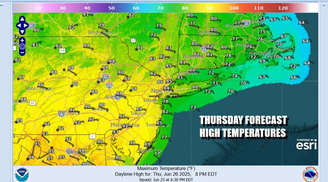
The weather front is going to linger across Eastern Pennsylvania to Southern New England through Thursday before it makes a move further south. It leaves Thursday as a very warm and humid day however with more of an east wind, temperatures will be about 10 degrees lower with highs reaching the low to mid 80s in most places from NYC northwarnd and upper 80s and lower 90s Southeastern Pennsylvania and Southern New Jersey south. Some thunderstorms could flare up Thursday afternoon and evening.
We are going to be dealing with an onshore flow Thursday night through Friday night so that means lower temperatures and lots of clouds. Friday highs will be in the mid 70s to some lower 80s. We will leave in the risk for some patchy shower or thunderstorm activity. Saturday could see temperatures trend back into the 80s with the risk for shower and thunderstorm activity but both Friday and Saturday will be dry most of the time. We should see genuine improvement Sunday as slightly drier air moves in from the northwest and a weather front passes offshore.
BE SURE TO DOWNLOAD THE FREE METEOROLOGIST JOE CIOFFI WEATHER APP &
ANGRY BEN’S FREE WEATHER APP “THE ANGRY WEATHERMAN!
MANY THANKS TO TROPICAL TIDBITS FOR THE USE OF MAPS
Please note that with regards to any severe weather, tropical storms, or hurricanes, should a storm be threatening, please consult your local National Weather Service office or your local government officials about what action you should be taking to protect life and property.


