
Presidents Day Weekend
Storm System Should Stay South With Minimal Issues
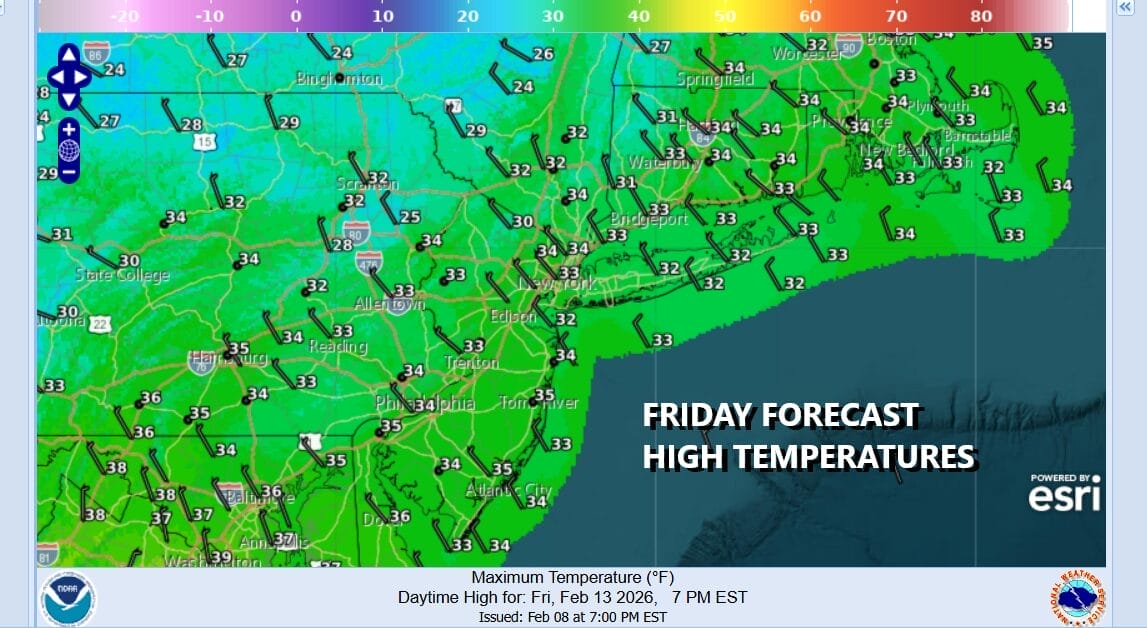
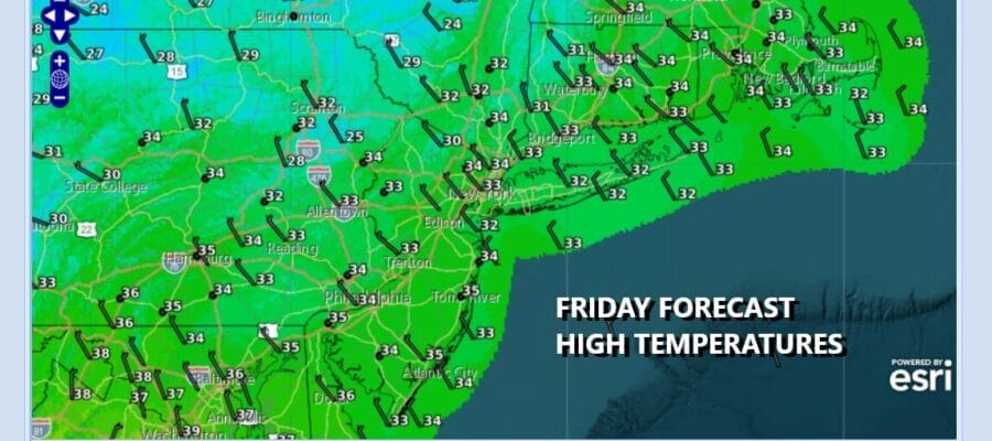
We are at the door step of the holiday weekend on a cold Friday but we have some sunshine for today. Temperatures this afternoon will top out in the low to middle 30s which should initiate a little snow and ice melt. Not much is on the radar but we do have an upper air disturbance over the Great Lakes that will pass through tonight. There could be a few snow showers with this disturbance and some areas could even see a coating of snow as it goes by. Much of this will happen overnight between midnight and 6am. Saturday morning lows will be in the upper teens inland and low to middle 20s everywhere else.
SATELLITE WITH LIGHTNING STRIKES

WEATHER RADAR

We do not see any serious weather issues for the weekend. Low pressure is forecast to develop in Texas tonight spreading rain and some thunderstorms in the Western Gulf States tonight and gradually the rain will spread eastward Saturday into the Lower Ohio & Tennessee Valley. Eventually the rain will move into the Middle Atlantic and Southeastern States Sunday.

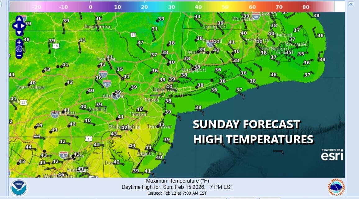
Northwest winds in the upper atmosphere will keep the low from moving up the coast and instead it will slide eastward late Sunday and early Monday. The bulk of the precipitation will pass to the south but some of it could make into Southern New Jersey and Southeastern Pennsylvania and there could be some snow in the mix but it won’t last long and it won’t amount to much.
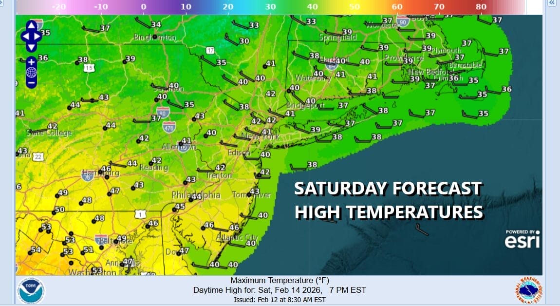
There are no weather issues for Saturday other than some early clouds but much of the day will be partly to mostly sunny. Highs will reach the upper 30s and lower 40s. Sunday is shaping up to be a cloudy day thanks to that storm system to the south. High temperatures will be in the 30s to around 40 degrees in most places.
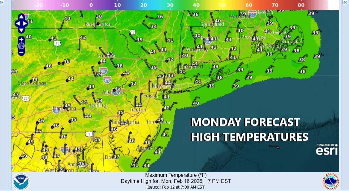
The straight east track will take rain out to the east Monday morning early and Presidents Day will be a day of clouds giving way to sunshine. There is no cold air behind this low to speak of so the strengthening mid February sun should allow temperatures Monday to reach into the 40s in most places.
Temperatures for much of next week will be running above average for a change and we could see highs in the mid to upper 40s Tuesday and possibly into the 50s in some places Wednesday. The day to day forecast is going to be tricky thanks to a frontal boundary that will be setting up Tuesday night and low pressure in the Midwest sliding along that boundary Tuesday night into Wednesday so we could see some rain with this and maybe some snow to the north in Upstate New York and into New England. The end of next week could be complicated by another low from the Great Lakes that will be heading southeastward.
BE SURE TO DOWNLOAD THE FREE METEOROLOGIST JOE CIOFFI WEATHER APP &
ANGRY BEN’S FREE WEATHER APP “THE ANGRY WEATHERMAN!
MANY THANKS TO TROPICAL TIDBITS FOR THE USE OF MAPS
Please note that with regards to any severe weather, tropical storms, or hurricanes, should a storm be threatening, please consult your local National Weather Service office or your local government officials about what action you should be taking to protect life and property.


