
Our Nice Late Summer Early Autumn Weather Continues
With Little Rain In the Forecast
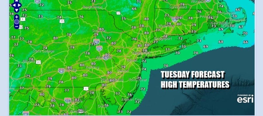
It is another day of sunshine as satellite loops show little in the way of cloud cover from Maine to Northern Florida. Radars show hardly anything at all up and down the East Coast. This has been a remarkable stretch of late summer/early autumn weather with hardly any rain over the last 9 days and we have mostly dry weather ahead. As for today it is another day of partly to mostly sunny skies. High temperatures this afternoon will reach the upper 70s to around 80 degrees. It will be 5 to 7 degrees cooler at the beaches with local sea breezes.
SATELLITE WITH LIGHTNING STRIKES

WEATHER RADAR

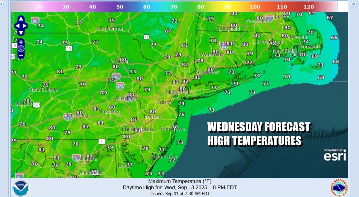
Most lows tonight will be in the 50s to around 60 degrees. Some cool spots well north and northwest (mostly north of Route 84) could see some 40s by Wednesday morning. Wednesday will be another day of partly to mostly sunny skies and once again, highs will be in the 70s to near 80 with an ocean wind keeping the coast about 5 to 8 degrees cooler. Once again radars will be silent with no rain.

We do have two weather fronts approaching. The first will be late Thursday and Thursday night. Since the Atlantic Ocean and the Gulf of Mexico remain virtually cut off, moisture with this front will be limited. We might see some scattered showers or an isolated thunderstorm when the front passes Thursday evening however the bulk of the moisture will pass to the north in New England and Upstate NY. A second front arrives Saturday with the chance for some showers or a thunderstorm when the front passes late in the day or Saturday evening. This front might have a higher chance of producing some rain as it goes by.
Ahead of this Wednesday and most of Thursday should be fine with no worse than partly sunny skies. It will turn a little warmer but only back to near average for this time of year. Wednesday highs will be in the 70s to around 80 degrees. Thursday might see highs reaching the lower 80s before the front passes. Temperatures both days will be cooler along south and east facing shorelines with a wind off the ocean. Friday looks to be warm as the air behind the first front is not all that cool. Highs will be in the lower 80s in most places. We look for more clouds for Saturday with afternoon showers or a thunderstorms followed by another shot of cool dry air beginning Sunday and taking us into the first part of next week.
BE SURE TO DOWNLOAD THE FREE METEOROLOGIST JOE CIOFFI WEATHER APP \\\&
ANGRY BEN’S FREE WEATHER APP “THE ANGRY WEATHERMAN!
MANY THANKS TO TROPICAL TIDBITS FOR THE USE OF MAPS
Please note that with regards to any severe weather, tropical storms, or hurricanes, should a storm be threatening, please consult your local National Weather Service office or your local government officials about what action you should be taking to protect life and property.


