
One Last Cold Day Before Warmup Brings Rain Late Week
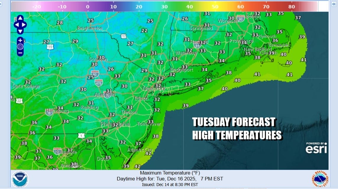
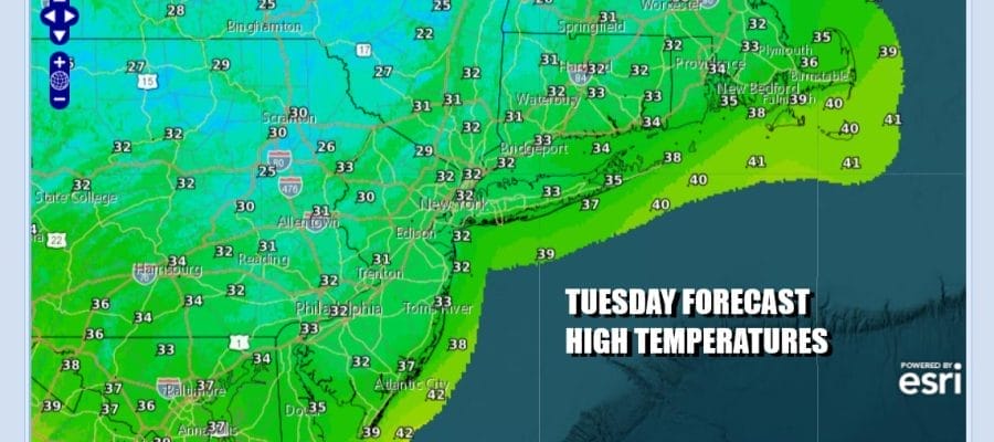
it is a cold morning across the Northeast and Northern Mid Atlantic states as we have hit bottom in the teens to near 20 this morning. There are some clouds streaming across the Great Lakes and the Northeast and we are on the edge of those clouds. Overall today it will be no worse than partly sunny. Temperatures are however are going to have a tough time and high temperatures will only reach the lower 30s in most places. The clouds represent warmer air that is moving eastward and we will start to feel that soon enough as the core of the cold air moves off the Middle Atlantic coast. Radars are quiet today and we should be dry for the next couple of days.
SATELLITE WITH LIGHTNING STRIKES

WEATHER RADAR

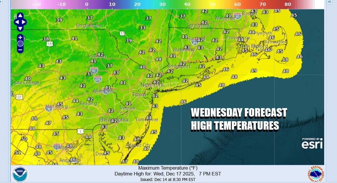
We are going to see temperatures not drop as low tonight as a southwest flow takes over. Most lows tonight will be in the 20s with teens inland. There should be enough of a breeze to keep temperatures relatively uniform. Wednesday we will see temperatures finally approach normal or even a shade above normal. Skies should be no worse than partly sunny and highs will reach the 40s by afternoon.
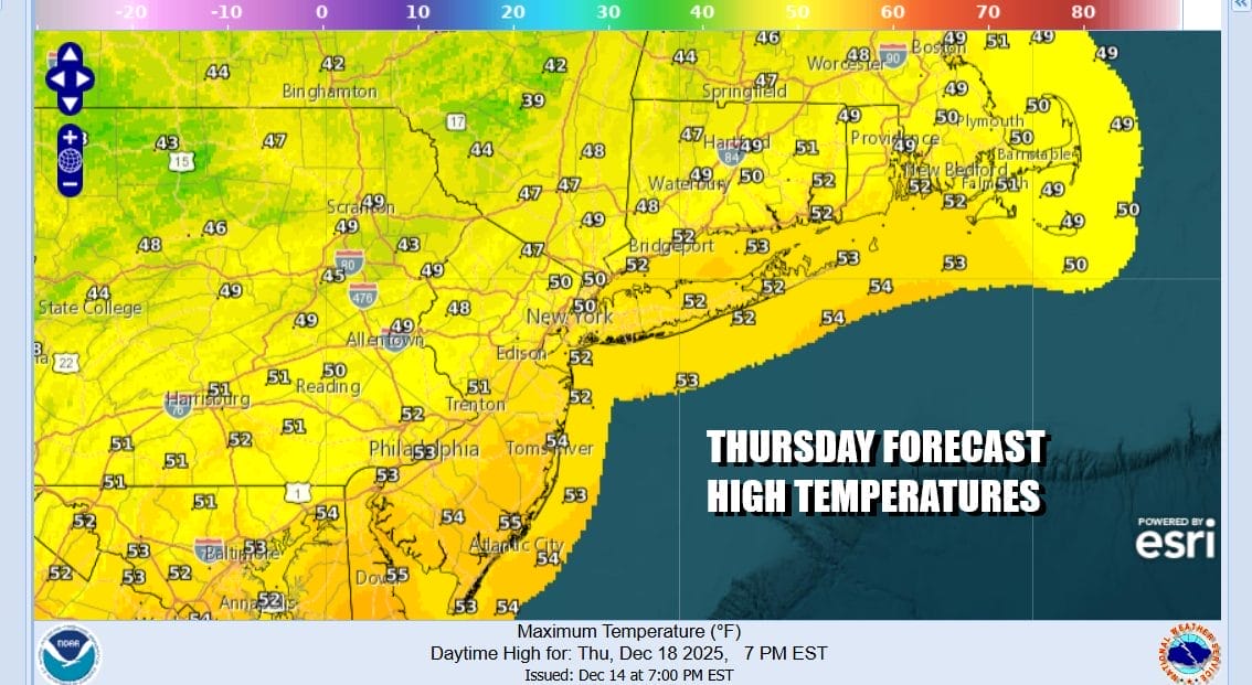
The warm up continues Thursday but a strong storm will be moving across Southern Canada from west to east over the next couple of days and with that storm is a trailing cold front that will run from the Great Lakes to the Gulf Coast. The strong upper air feature with this weather front will open up the Gulf of Mexico and the Atlantic ocean. Moisture surging ahead of this along with the warmer air will set off a rather impressive line of showers and thunderstorms Thursday across the Lower Great Lakes and extending southward to the Gulf Coastal states.

The surging warm air means that temperatures Thursday will reach into the 50s in many locations. We execpt to see any early sunshine to give way to increasing clouds as the front draws closer. There might be some renegade showers late in the afternoon away from the coast but the main rain will come Thursday night into Friday morning and there might even be a few thunderstorms in the mix.
Weather models are a little slower with this cold front so we probably see rain lingering into the morning hours but we should see showers and thunderstorms ending later in the morning and that will be followed by improving weather conditions in the afternoon along with a developing gusty northwest wind. Temperatures Friday will hover in the 50s at least for awhile but probably won’t drop until Friday night when the upper trough passes. The weekend looks to be dry and colder though the air behind this front doesn’t compare with some of the cold air masses we have experienced in the last couple of weeks. Rainfall amounts will be in the 3/4 inch to 1 inch range with some locally higher amounts in areas that experience convective activity.
BE SURE TO DOWNLOAD THE FREE METEOROLOGIST JOE CIOFFI WEATHER APP &
ANGRY BEN’S FREE WEATHER APP “THE ANGRY WEATHERMAN!
MANY THANKS TO TROPICAL TIDBITS FOR THE USE OF MAPS
Please note that with regards to any severe weather, tropical storms, or hurricanes, should a storm be threatening, please consult your local National Weather Service office or your local government officials about what action you should be taking to protect life and property.


