
One Front Exits & Another Arrives
Later Sunday Into Monday Morning

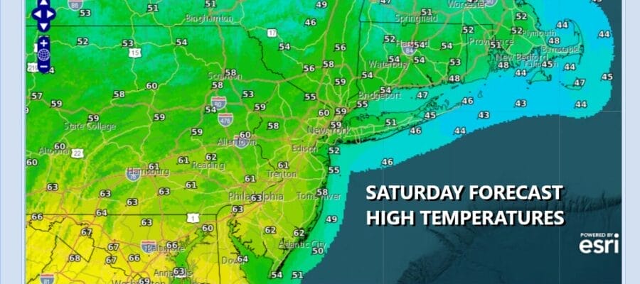
One cold front has passed offshore this morning and now we will settle back in what should be a partly sunny type of day. Clouds to the north are moving southeastward thanks to the northwest flow in the upper atmosphere so they will be in the mix today. Radars however are nice and quiet and should remain so at least into the first part of Sunday. High today will generally be in the upper 50s and lower 60s though south and east facing shorelines will likely be cooler with a wind off the ocean.
SATELLITE WITH LIGHTNING STRIKES

WEATHER RADAR

Most lows tonight will be in the upper 30s inland and low to mid 40s everywhere else. Look for some clouds to start moving in. Sunday with a cold front starting the day to the north there will be some showers in Upstate New York but I think they should stay away until mid or late afternoon as the front sinks southward, moves through and a wave develops on the front.

We should warm up some Sunday especially if we can manage a little sunshine in the mix which I think we can at least through the first half of the day. Temperatures Sunday should reach the 60s just about everywhere. In South Jersey and points south, highs will reach the upper 60s and lower 70s as these areas likely see a bit more in the way of sunshine and the front impacts take a little longer to make their way south.

Sunday night into Monday morning the wave on the front brings an area of rain through. Much of it should be done by daybreak or shortly afterwards. Behind the front comes a colder air mass and we will see temperatures settling in the 50s. Sunshine should develop from northwest to southeast along with breezy conditions as colder air arrives. By Tuesday morning we will be in the mid 20s to lower 30s. Tuesday will be cold with clouds and sun but high temperatures just in the 40s. Another front arrives late Wednesday with the chance for a few showers.
BE SURE TO DOWNLOAD THE FREE METEOROLOGIST JOE CIOFFI WEATHER APP &
ANGRY BEN’S FREE WEATHER APP “THE ANGRY WEATHERMAN!
MANY THANKS TO TROPICAL TIDBITS FOR THE USE OF MAPS
Please note that with regards to any severe weather, tropical storms, or hurricanes, should a storm be threatening, please consult your local National Weather Service office or your local government officials about what action you should be taking to protect life and property.


