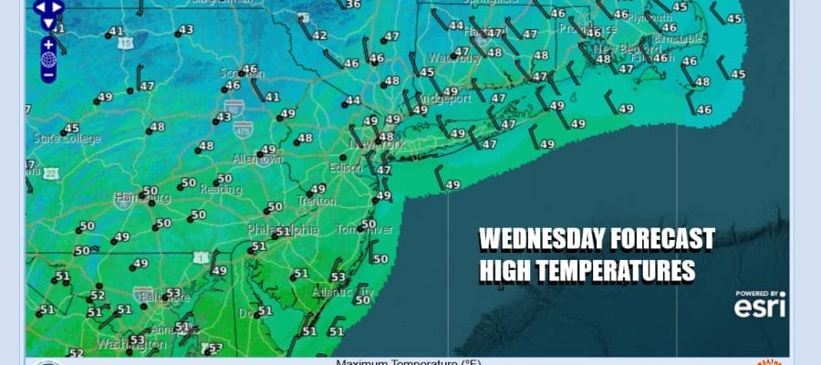

Miserable Raw Start But A Better Finish Dry Thursday Into Friday
You may have waken to a miserable raw morning. Rain from low pressure moving off the Virginia coast made it to about NYC, Northern New Jersey and Long Island but it didn’t amount to much. Temperatures were in the 30s and there were even a few snow flakes along the northern flank. To the south some heavier is moving off the New Jersey coast and the entire rain shield on the radar will move offshore before too long. Weather conditions should improve this afternoon as drier air from Eastern Canada funnels southward. Look for leftover clouds with some developing breaks of sunshine this afternoon with highs mostly in the 40s.
SATELLITE WITH LIGHTNING STRIKES

WEATHER RADAR

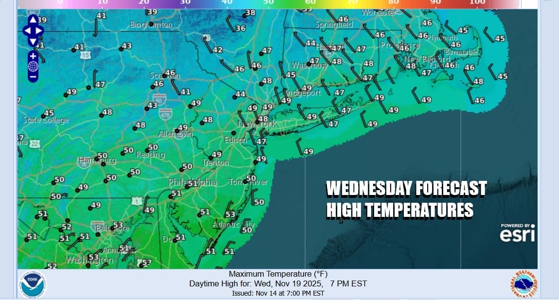
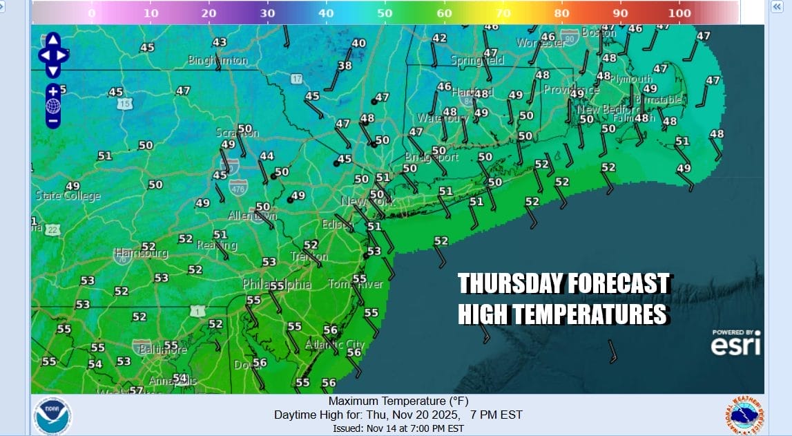
Northerly winds will be funneling colder air southward as skies clear tonight. Overnight lows will be in the 20s inland and low to middle 30s in most coastal and urban areas. High pressure builds across the Northeast leaving us with a mostly sunny Thursday. Highs will be in the upper 40s to some lower 50s.
There has been a considerable amount of energy coming into the Western US from the Pacific. The blocky pattern across the North Atlantic has forced these systems to track straight east and to the south of Southern New England and also they tend to remain weak and do not develop much as they head offshore. Given the state of the north Atlantic there isn’t any room for development of these disturbances.

The next system in this flow is going to be taking a similar track to this one today where it moves straight east across the Lower Tennessee Valley and then exits off the Virginia coast Friday night into early Saturday morning. This system looks weaker so it will leave us with some sunshine and some arriving clouds Friday. Highs will be in the middle to upper 50s. Some warm spots in South Jersey could reach 60 degrees.
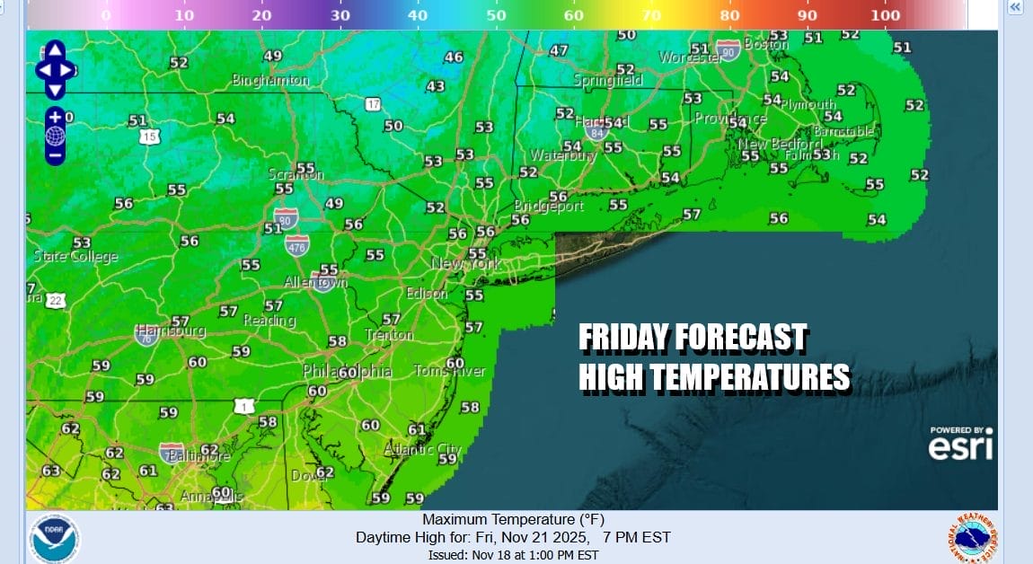
We will throw in the chance for a short period of light rain or showers late Friday into Friday night. Otherwise we will see a nice dry weekend of no worse than partly sunny skies. Highs Saturday and Sunday will likely be in the low to mid 50s both days. Next week brings the Thanksgiving holiday and right now we see there is the chance for some showers late Tuesday into Tuesday night with a cold front. Late week (probably Friday) cold air will arrive. In between for Wednesday and Thursday there are some questions regarding the Tuesday front, whether it stalls offshore, and whether we get some wave development.
BE SURE TO DOWNLOAD THE FREE METEOROLOGIST JOE CIOFFI WEATHER APP &
ANGRY BEN’S FREE WEATHER APP “THE ANGRY WEATHERMAN!
MANY THANKS TO TROPICAL TIDBITS FOR THE USE OF MAPS
Please note that with regards to any severe weather, tropical storms, or hurricanes, should a storm be threatening, please consult your local National Weather Service office or your local government officials about what action you should be taking to protect life and property.


