
Meteorological Spring Begins With A Shot of Cold Air
Followed By Warm Mid & Late Week Temperatures
A wave on a frontal boundary to the south has moved through this morning. An area of snow sleet and a little rain has play it’s way through from west to east and now we will spend the rest of the day with improving weather conditions though it is cold. Northerly winds are ushering in a cold start to the month of March and a cold start to meteorological spring which begins today. Temperatures this afternoon will hold mostly in the low to middle 30s with gusty northerly winds and then under clear skies tonight we will see temperatures drop to Monday morning lows in the teens to near 20 degrees.
SATELLITE WITH LIGHTNING STRIKES

WEATHER RADAR

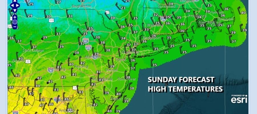
Meteorological spring are the months where temperatures warm the fastest and those months are March, April, and May. Average highs start the month in the middle 40s (plus or minus a few degrees here and there) to middle 50s by the end of March. Our winter pattern of consistent cold is over and we will look to a more variable pattern going forward. It doesn’t mean we won’t see shots of cold air nor doesn’t mean that the snow is done as there is time for one or two more snow events if the opportunity presents itself.
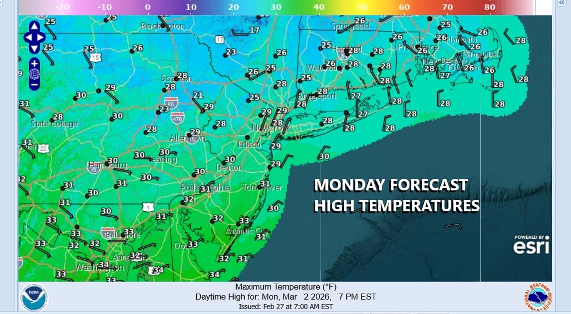
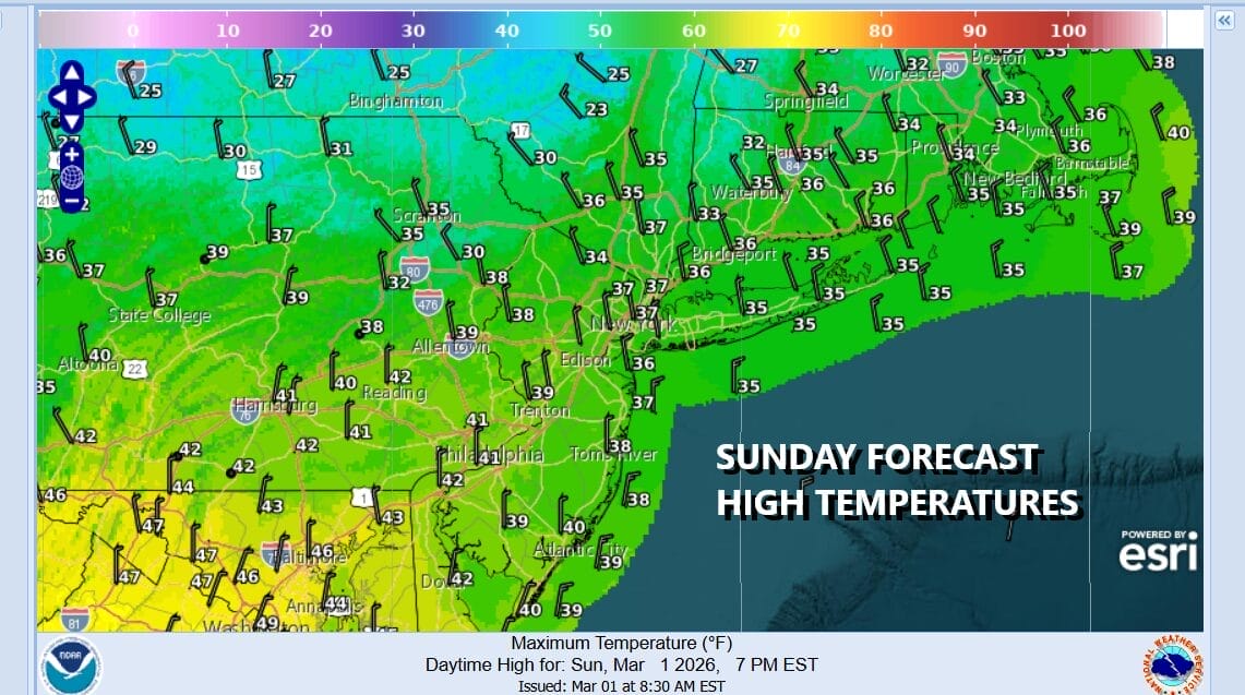
In the meantime we have Monday which will be a very cold day even though we will have plenty of sunshine. High temperatures will be only in the upper 20s and lower 30s which is 15 degrees or so below average for early March. This cold air mass however will be exiting quickly as a warmer pattern begins to take hold Tuesday. Pacific air is flooding the US with warmer temperatures and some of that warm air is heading to the Northeast and Mid Atlantic states.
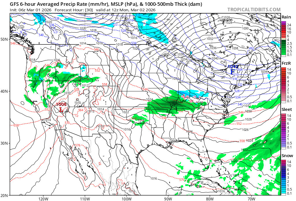
In that transition to a warmer pattern, two areas of low pressure are heading to the northeast into the Great Lakes. Tuesday sees increasing clouds with rain developing late in the day lasting into early Wednesday. It might still be cold enough for some inland areas like Northeast Pennsylvania, Northwest New Jersey, the Hudson Valley and Connecticut from Interstate 84 north, to see a little sleet or freezing rain at the start before it goes to plain rain. Temperatures Tuesday will top out in the upper 30s to mid 40s. Then Wednesday we see some improvement with highs reaching the 50s. Thursday to me looks like it could be the warmest day of the work week with highs in the 60s especially away from the ocean. There is also the likelihood of some showers late Thursday into early Friday as a cold front passes. All in all after the early week cold, it is going to feel like spring around here.
BE SURE TO DOWNLOAD THE FREE METEOROLOGIST JOE CIOFFI WEATHER APP &
ANGRY BEN’S FREE WEATHER APP “THE ANGRY WEATHERMAN!
MANY THANKS TO TROPICAL TIDBITS FOR THE USE OF MAPS
Please note that with regards to any severe weather, tropical storms, or hurricanes, should a storm be threatening, please consult your local National Weather Service office or your local government officials about what action you should be taking to protect life and property.


