
March Arrives With A Short Lived Cold Air Mass
A More Spring Like Pattern Emerges Next Week
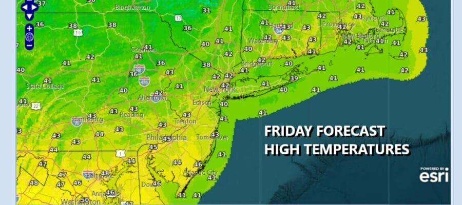
We have a arrived at the doorstep of the weekend and today, getaway day, if you are getting away, is going to be a nice day. We have mainly clear skies on the satellite with nothing more than some passing clouds across the Northeast and Northern Mid Atlantic states. The radars are nice and quiet. The “cold” air mass overhead is rather stale so with the late February sunshine will see temperatures in the 40s today and plenty of sunshine. Radars are nice and quiet and that will remain the case through Saturday. Lows will be in the mid 20s to lower 30s under mainly clear skies overnight and Saturday morning.
SATELLITE WITH LIGHTNING STRIKES

WEATHER RADAR

On to the weekend and Saturday will definitely be the better of the two weekend days. It will be a day of sunshine and melting snows along with warm temperatures. We are however in that time of year where wind direction is key to how high temperatures get. A south wind off the cold ocean with keep areas along coastal New Jersey and Long Island in the 40s but areas inland should make it into and through the 50s in some places. I wouldn’t be shocked to see some 60 degree highs popping up here and there.

Another cold front will pass through Saturday night with little fan fare as it goes by but an upper trough will swing through the Northeast Sunday. This upper trough runs ahead of a very cold air mass that will be building for Sunday night into Tuesday. The good news is that this will be a quick cold snap and we will see a warmer spring like pattern emerge later next week.

There could be a brief period of rain or snow as that upper trough goes by and then the colder air will start to spread in Sunday afternoon and early evening. The highs for the day will be leftover from the early morning hours Sunday when temperatures will be in the low to mid 40s and we will likely spend much of the dayside Sunday with temperatures holding in the 30s.

Northerly winds will bring colder air and by Monday morning we will see lows in the teens to near 20. Monday will be a day of ineffective sunshine and highs just in the upper 20s and lower 30s. This cold air mass will pull out Tuesday as low pressure heads our way. There might be some snow at the onset of precipitation Tuesday morning but it will change over to rain as the cold air pulls out and warmer air replaces it. Beginning Wednesday we will be in a warmer the average weather pattern that is likely to last possibly into mid month before we get another pattern flip.
BE SURE TO DOWNLOAD THE FREE METEOROLOGIST JOE CIOFFI WEATHER APP &
ANGRY BEN’S FREE WEATHER APP “THE ANGRY WEATHERMAN!
MANY THANKS TO TROPICAL TIDBITS FOR THE USE OF MAPS
Please note that with regards to any severe weather, tropical storms, or hurricanes, should a storm be threatening, please consult your local National Weather Service office or your local government officials about what action you should be taking to protect life and property.


