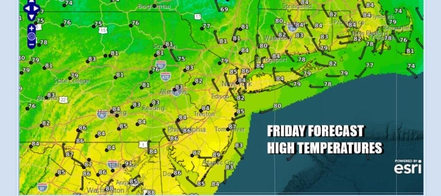

Lower Humidity & Sunshine Friday
Weekend Outlook Return to Humidity & Some Showers
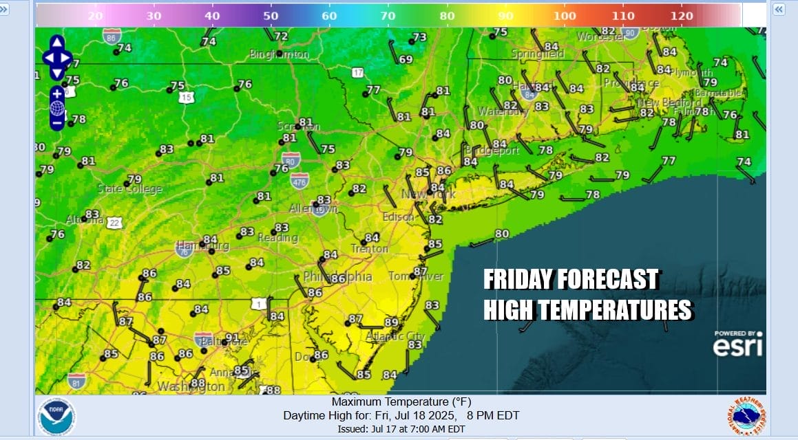
Finally after sitting in 70 degree plus dew points for 10 days in a row we are seeing a break in the humidity today. It is a short break and it may take awhile for dew points to ease across Southern Pennsylvania and South Jersey. To the north in Northern New Jersey, Northern Pennsylvania northeast into the Hudson Valley and Southern New England dew points will settle into the 50s which will make it nice and comfortable. We should enjoy at least some sunshine today though some clouds will be around from time to time. Highs today will be in the low to middle 80s.
SATELLITE WITH LIGHTNING STRIKES

WEATHER RADAR

As indicated earlier the humidity break will be short lived as the old frontal boundary lies stalled to the south across the Middle Atlantic states. Waves of downpours and thunderstorms will lie across West Virginia and Virginia today and some of that moisture will start to move northward Saturday as the front backs up as a warm front and heads slowly to the northeast.

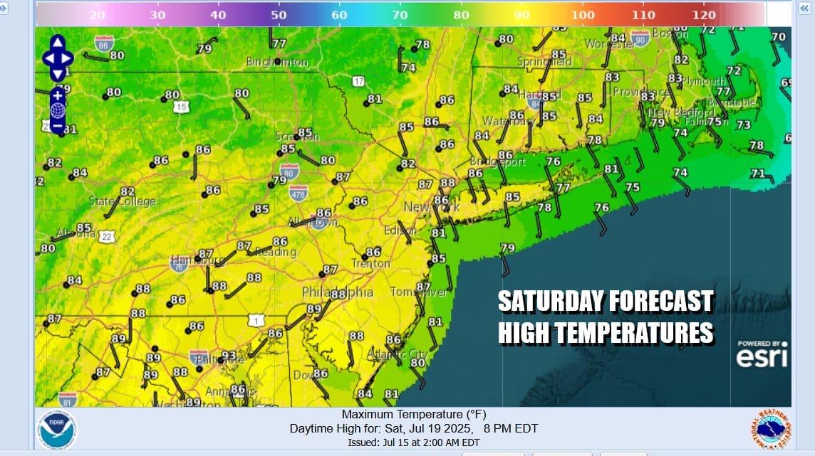
Tonight we will have some clouds around and most lows will be in the 60s. Some showers could start to inch northward into Southern New Jersey and Southern Pennsylvania by daybreak. Saturday we will see dew points start to climb and by days end we will be back in the upper 60s to near 70 so it will start to become muggy. Clouds will increase and there is the chance for some showers or a thunderstorm popping up Saturday afternoon and evening through it will not be area wide coverage. Highs will be in the 80s.
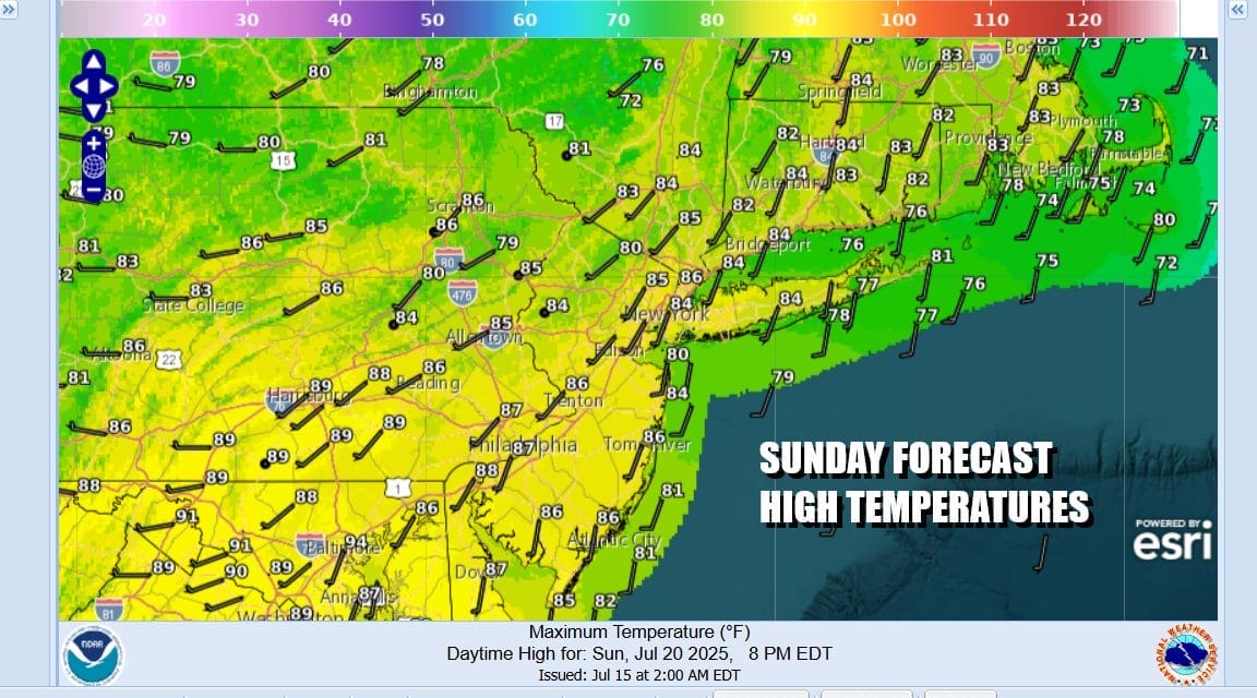
We will likely see some showers around Saturday night but not everywhere. The risk is there however and we need to include it in the forecast. Sunday we will see some showery rains around and the risk of a thunderstorm into Sunday midday. The Storm Prediction Center has a marginal risk for isolated severe thunderstorms as a cold front passes. Highs Sunday will again be in the 80s.
Winds will shift to the northwest late Sunday and Sunday night and we have another shot of drier air coming out of Canada. This time around however the dry air mass will have staying power as the frontal boundary pushes far enough south into the Mid Atlantic so that it will not be an issues. Monday and Tuesday will both be nice and sunny with high temperatures in the lower 80s. More importantly humidity levels will be low and it will be nice and comfortable into early Wednesday before humidity levels begin to rise again.
BE SURE TO DOWNLOAD THE FREE METEOROLOGIST JOE CIOFFI WEATHER APP &
ANGRY BEN’S FREE WEATHER APP “THE ANGRY WEATHERMAN!
MANY THANKS TO TROPICAL TIDBITS FOR THE USE OF MAPS
Please note that with regards to any severe weather, tropical storms, or hurricanes, should a storm be threatening, please consult your local National Weather Service office or your local government officials about what action you should be taking to protect life and property.


