
Hot Humid Through Wednesday Storms Thursday,
Heavy Rain Thursday Night into Friday, Beautiful Dry Cool Weekend

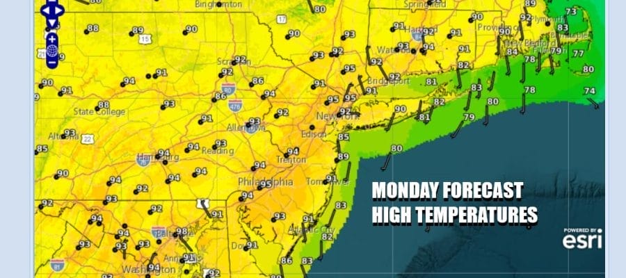
The work week begins and we are looking ahead to hot and humid weather for the next 3 days. There may still be smokey haze from the Northern Canada wildfires but it should be far less today than in past days. We will see a good deal of sunshine today and we do not anticipate any showers or thunderstorms developing, even isolated ones. High temperatures today will reach the low to a few middle 90s. Temperatures will be a little cooler along coastal areas as local sea breezes develop but relief to the heat and humidity will be kept to a minimum. Tonight will be very warm and humid. Most lows will be in the 70s.
SATELLITE WITH LIGHTNING STRIKES

WEATHER RADAR

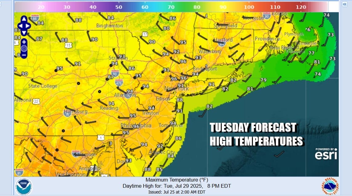
Heat and humidity will roll along for Tuesday and Wednesday. Once again for Tuesday shower and thunderstorm activity will be minimal to near zero. Sunshine will take temperatures up to a range of 90 to 95 degrees. Local sea breezes will develop along south and east facing shorelines in the afternoon and evening hours.
Wednesday we will see another hot humid day but there is an upper trough that will be dropping southeastward from New England. This opens the door for scattered shower and thunderstorm activity in the afternoon and evening and there is the chance for some isolated severe thunderstorms to be in the mix. Highs Wednesday once again will be in a range of 90 to 95 degrees.

Things get complicated for Thursday as a front approaches, moves through and slows down. We will see increasing chances for showers and thunderstorms as the day wears on. It appears that the front will stall for a short time Thursday night as we wait for a wave to develop along the frontal boundary and move northeastward.

This sets up for a prolonged period of rain and potentially heavy rain for Thursday night into part of Friday. As winds shift to the north and northeast Thursday we will see lower highs in the 80s. Then as the rains come Thursday night so will cooler air. Most lows will be in the 60s Thursday night. Friday we could see rain hang around for the first part of the day but once the wave moves away we will see improving weather conditions with significantly lower temperatures and humidity. Friday highs will be in the 70s. Saturday will be mostly sunny and cool for early August with highs in the 70s. We should see dry air into Sunday at least with sunshine and highs in the upper 70s to some lower 80s. As for the rainfall Thursday night and Friday, it could be on the generous side, on the order of a few inches and there may be some flash flood issues for some folks. We will be focusing our attention in this area over the coming days.
BE SURE TO DOWNLOAD THE FREE METEOROLOGIST JOE CIOFFI WEATHER APP &
ANGRY BEN’S FREE WEATHER APP “THE ANGRY WEATHERMAN!
MANY THANKS TO TROPICAL TIDBITS FOR THE USE OF MAPS
Please note that with regards to any severe weather, tropical storms, or hurricanes, should a storm be threatening, please consult your local National Weather Service office or your local government officials about what action you should be taking to protect life and property.


