
Heat Humidity Severe Thunderstorm Risk Ahead of the Weekend
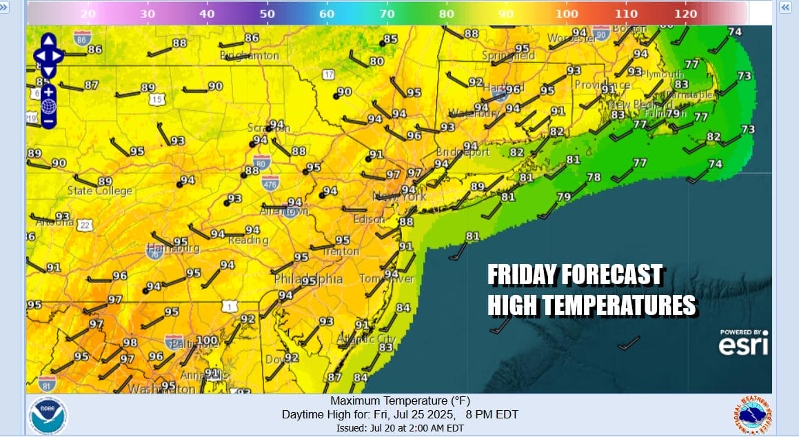
We have a very hot and very humid day to finish off the week. All sorts of “melt in place” advisories and warnings are up (Heat Advisories & Extreme Heat Warnings) as highs will reach the mid to upper 90s. Of course let’s make it sound even more apocalyptic by saying that “yes but it feels like 110! It’s hot. It’s very humid. It’s summertime. It kind of works that way.
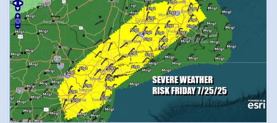
We do have an east-west oriented weather front across Upstate NY and New England that will be moving southward today and there is enough instability and dynamics for thunderstorms and the possibility of some areas of organized severe weather. The Storm Prediction Center has a “slight risk” or a 15 percent chance for severe thunderstorms. We suspect that there could be some stronger individual cells that develop with a few organized clusters or small line segments of storms. We will be watching radar developments later today.
SATELLITE WITH LIGHTNING STRIKES

WEATHER RADAR

Thunderstorms late this afternoon and evening will move offshore and then we will see temperatures come off a bit over the weekend. Of the two weekend days Saturday will be the better of the two. We will see winds go more onshore which will hold temperatures down. We are leaving the mention of showers or thunderstorms out of the forecast for the daytime Saturday.

Another weather system will be moving quickly across the Ohio Valley and the Northeast and that looks to bring showery downpours and thunderstorms Saturday night through at least part of Sunday. Right now there is no indicated severe weather risk forecast from the Storm Prediction Center but we could go to a marginal risk for isolated severe storms in later forecasts from SPC.

Most highs Saturday will be in the mid to upper 80s. Some warm spots could touch 90 but that will be lower than today. We should see a mix of sun and clouds with more clouds coming late in the day as that weather system approaches for Saturday night and Sunday. Showery rains and thunderstorms could be around into the afternoon so with less sun, temperatures will be in the low to mid 80s for highs.

Heat & Humidity will continue next week with occasional chances or scattered thunderstorms. Highs will likely start reaching back into the 90s Monday and we will be in that range coupled with high humidity through at least Wednesday. A stronger weather front is due at the end of the week along with a cooler drier air mass that follows as July ends and August begins.
BE SURE TO DOWNLOAD THE FREE METEOROLOGIST JOE CIOFFI WEATHER APP &
ANGRY BEN’S FREE WEATHER APP “THE ANGRY WEATHERMAN!
MANY THANKS TO TROPICAL TIDBITS FOR THE USE OF MAPS
Please note that with regards to any severe weather, tropical storms, or hurricanes, should a storm be threatening, please consult your local National Weather Service office or your local government officials about what action you should be taking to protect life and property.


