
Heat Humidity On The Way Along With Severe Weather Risk Later This Week
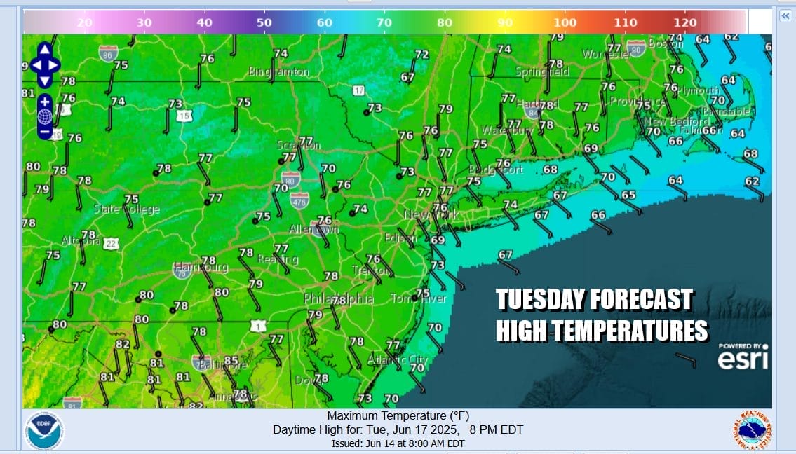
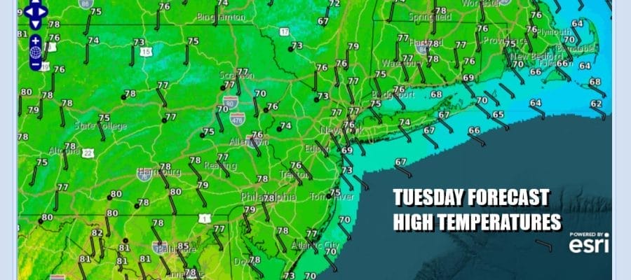
We still have more work to do when it comes to getting rid of the onshore flow. We are making some progress but we still have lots of clouds today and we still have winds coming in from off the ocean. There might be some brightening of skies here and there but there will also be some light rain or drizzle around. There might also be a few scattered showers or a thunderstorm to deal with in some place. Temperatures today will struggle again between the cloud cover and the ocean wind. Most highs will be in the upper 60s to lower 70s in most places although temperatures could be a little higher across South jersey and Southeastern Pennsylvania as well as points southward.
SATELLITE WITH LIGHTNING STRIKES

WEATHER RADAR

The Storm Prediction Center is indicating severe weather risk today over Eastern Maryland, Delaware, and Virginia. A marginal risk for isolated severe thunderstorms is forecast this this area. However we are going to see a gradual transition to warmer and more humid air across Eastern Pennsylvania to Southern New England over the next 2 days. The onshore flow finally breaks down Wednesday.

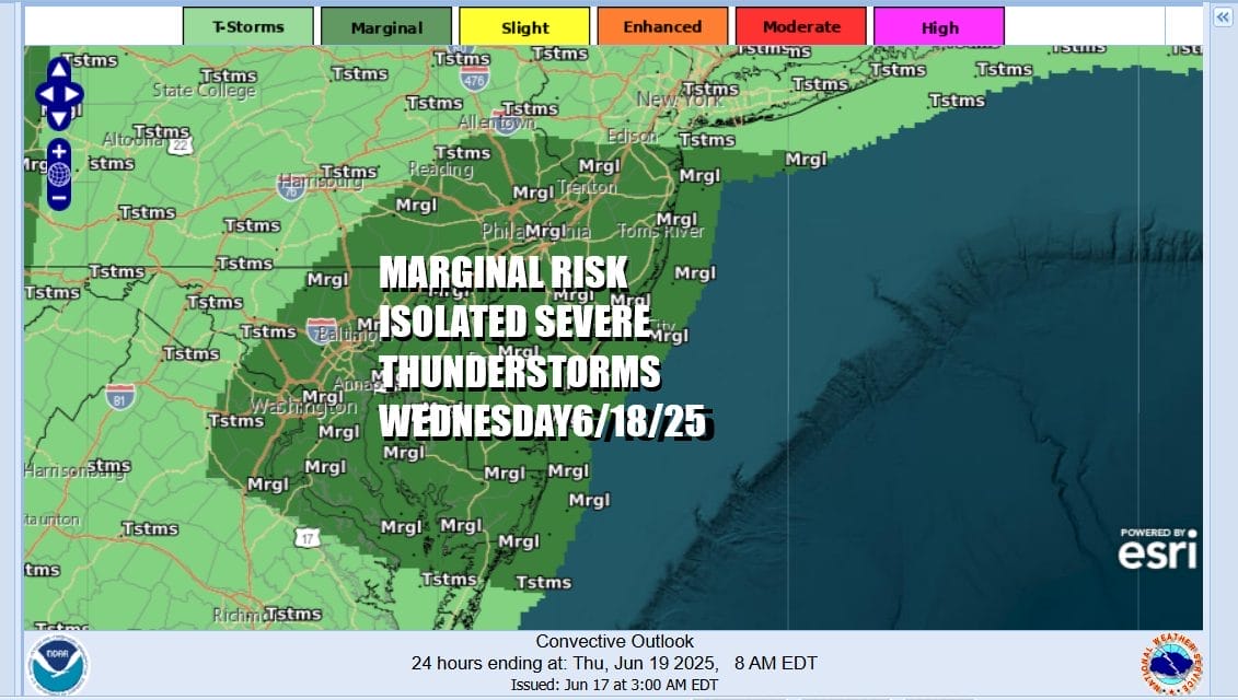
The transition to warmer and more humid air, and the continuation of little ripples moving along in the west to east flow, it opens the door to the risk for some afternoon and evening thunderstorms Wednesday and there is a chance there could be some isolated severe thunderstorms in the mix. The Storm Prediction Center has a marginal risk for Central and South Jersey, Eastern Pennsylvania and points southward.
Winds will turn more south and southwest during Wednesday and if we couple that with fewer clouds and more in the way of sunshine. Temperatures will be able to climb higher. Expect skies to be no worse than partly sunny Wednesday and then watch for some scattered thunderstorms and isolated severe thunderstorms late in the day. Highs should reach the upper 70s and lower 80s.

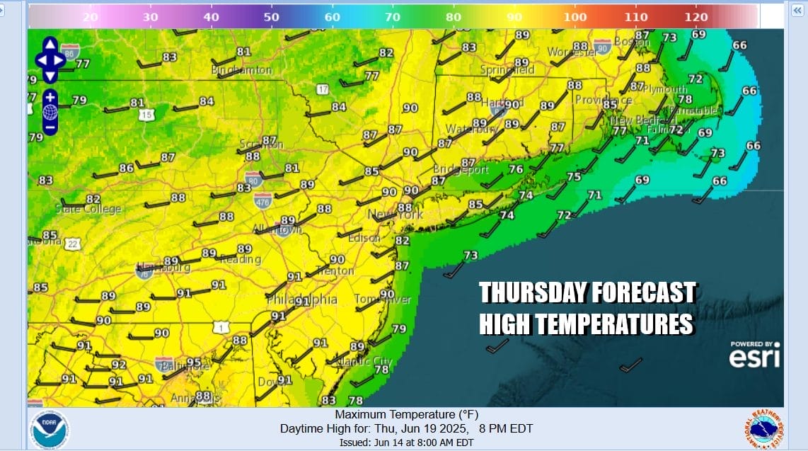
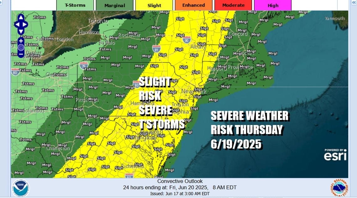
Moving ahead to Thursday, we see it being the hottest day of the week and it will also be a very humid day. Sunshine will take high temperatures into the upper 80s and lower 90s. Even coastal areas will see temperatures climb up toward 90 degrees before any sea breeze develops, if one develops at all.
Weather models are showing a strong short wave trough moving east across Southeast Canada and a cold front that goes with it approaching the East Coast. The Storm Prediction Center has been indicating severe weather risk in their long range forecast for parts of the Northeast and Mid Atlantic and now that it is in the short range, SPC is showing risk for severe thunderstorms from Northwest New England and Upstate NY, southward through New Jersey and Eastern Pennsylvania to Maryland Delaware and Virginia.
Thunderstorms will likely develop during the afternoon and move west to east. This system does move along so we should see improving weather conditions for Friday and the weekend. There is a chance we will not see much if any rain over the weekend as the atmosphere sets up for a prolonged period of heat and humidity next week.
BE SURE TO DOWNLOAD THE FREE METEOROLOGIST JOE CIOFFI WEATHER APP &
ANGRY BEN’S FREE WEATHER APP “THE ANGRY WEATHERMAN!
MANY THANKS TO TROPICAL TIDBITS FOR THE USE OF MAPS
Please note that with regards to any severe weather, tropical storms, or hurricanes, should a storm be threatening, please consult your local National Weather Service office or your local government officials about what action you should be taking to protect life and property.


