
Heat Humidity And Severe Thunderstorm Risk Thursday
Dry Cooler Friday Heatwave Next Week

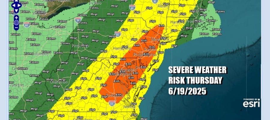
We have a very warm to hot day ahead across Eastern Pennsylvania to Southern New England. A warm front has passed to the northeast and a cold front is going to be pushing through late today and this evening. The atmosphere will be very unstable and the Storm Prediction Center is now forecasting an enhanced risk or 30 percent chance for severe thunderstorms in an area that extends from Northeast Virginia, across Maryland, Southeastern Pennsylvania, just about all of New Jersey into the Lower Hudson Valley. Slight risk or a 15 percent chance extends eastward and northward to Long Island, Connecticitut, Upstate NY and much of New England.
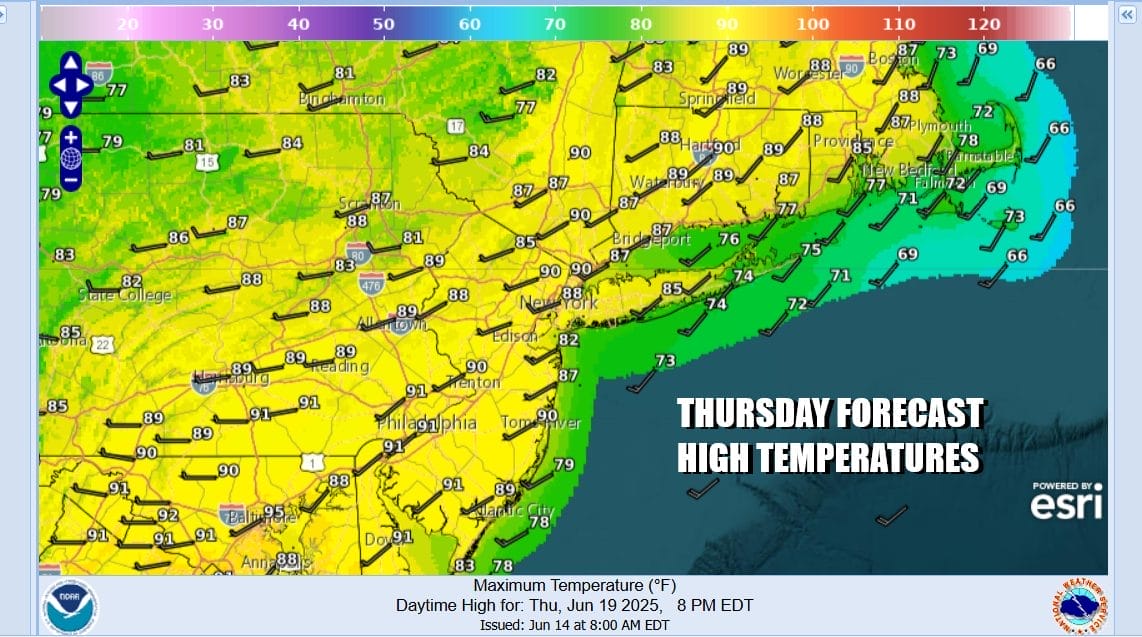
Sunshine into early afternoon will take highs to the upper 80s and even some lower 90s in hot spots. The wind direction will be from the west southwest and this is going to keep sea breezes at bay except for right along the immediate coastal areas. The lack of a cooling stabilizing marine influence will allow thunderstorms that develop this afternoon to stay stronger for longer.
SATELLITE WITH LIGHTNING STRIKES

WEATHER RADAR

We should also mention that there is a low chance but not zero, that an isolated tornado or two could spin up. The highest risk will come from the potential for straight line wind damage as the weather front and the thunderstorms move through. Once the front passes we will see a slightly cooler and slightly drier air mass build in for Friday.

High pressure will be settling in over the Mid Atlantic states through the weekend and into next week. Cold fronts will bo able to move through the Eastern US until the ridge building in the Eastern US flattens out or breaks down and that may not happen until sometime late next week. Also we are heading into a stretch where we will see little in the way of rain for the next 6 or 7 days.
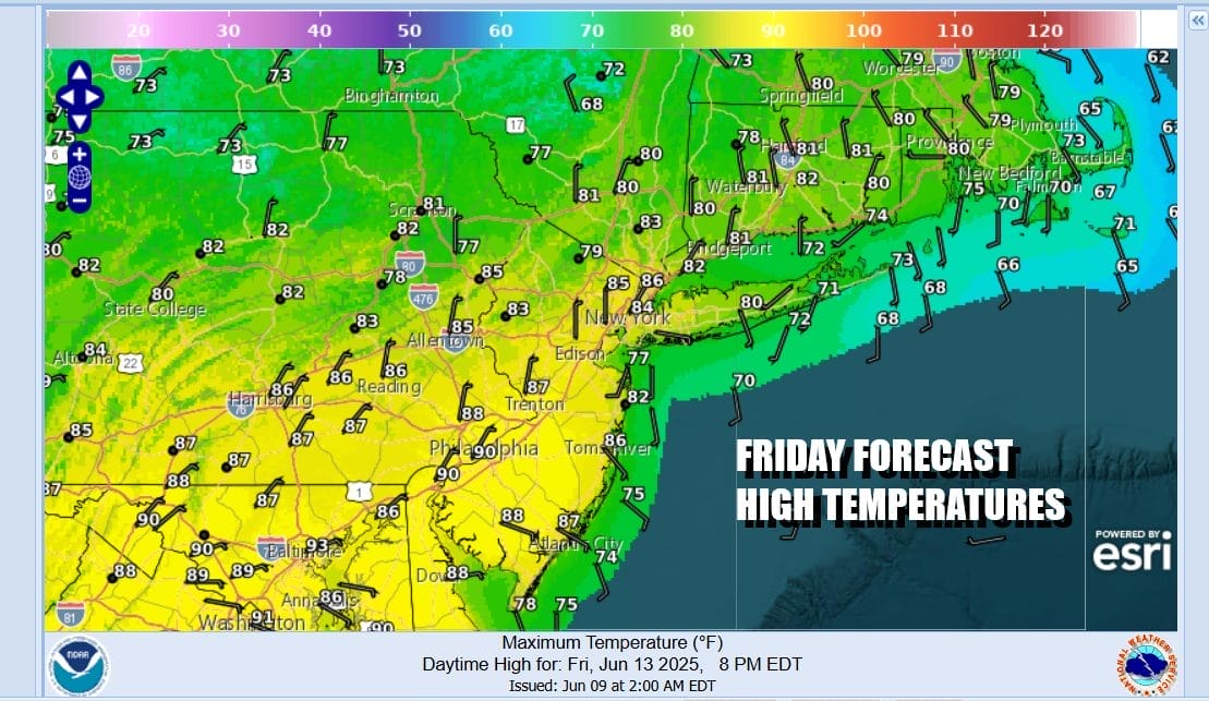
We will see humidity levels ease somewhat Friday and we are looking at a partly to mostly sunny day. Most highs Friday across Eastern Pennsylvania to Southern New England will be in the mid 80s. For the weekend the only disturbance we are watching is one that will be moving southeast from Canada into Northern New England. We expect this system to stay well to the north.

This will be the first weekend in almost 2 months where we have not see rain on at least one of the weekend days. Both days will be good for outdoor activities. Saturday will be partly to mostly sunny with high temperatures reaching the mid to upper 80s. Sunday we are going to see sunshine and it will be very warm to hot. Highs will reach the upper 80s to near 90 degrees in most places. Some low 90s are possible across Southern New Jersey and Eastern Pennsylvania.

Next week we expect to see 4 days of very hot and somewhat humid weather beginning Monday and lasting through Thursday. Highs each day will be in the 90s. It is possible that Tuesday we could see some hot spots hit 100 degrees. Thanks to the strong upper high, sinking air means heat but it also means that the atmosphere will be too stable for any shower or thunderstorm development so we will see little to no rain after today.
BE SURE TO DOWNLOAD THE FREE METEOROLOGIST JOE CIOFFI WEATHER APP &
ANGRY BEN’S FREE WEATHER APP “THE ANGRY WEATHERMAN!
MANY THANKS TO TROPICAL TIDBITS FOR THE USE OF MAPS
Please note that with regards to any severe weather, tropical storms, or hurricanes, should a storm be threatening, please consult your local National Weather Service office or your local government officials about what action you should be taking to protect life and property.


