
Father’s Day Weekend Showery Rains Tonight Through Sunday
Though There Will Be Dry Stretches At Times
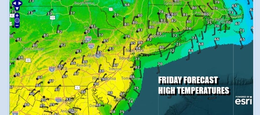
We have arrived at the doorstep of Father’s Day weekend and for Eastern Pennsylvania to Southern New England it will be another weekend where it rains on at least 1 if not both weekend days. It will not rain all the time and there will be dry periods, Sunday will be relatively better than Saturday as there will be less rain on the whole and longer dry periods. As for today we are seeing clouds have moved in and there will be some patchy areas of showery rains later today. Radars are beginning to show slowly increasing areas of precipitation. Most highs today will be in the 70s along the coast but inland areas could see highs in the upper 70s to some lower 80.
SATELLITE WITH LIGHTNING STRIKES

WEATHER RADAR

A stalled frontal boundary to the south lies across Northern Virginia to the Delmarva Peninsula. Waves of low pressure will be moving along this frontal boundary. The first such wave will be tonight into Saturday morning and you can expect rain overnight through the first half of Saturday before it tapers off from west to east.

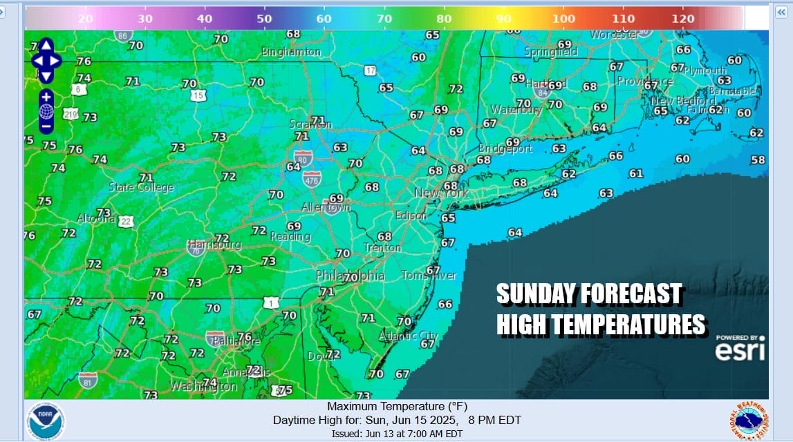
Unfortunately the frontal boundary will remain in place into early next week and as models show, other ripples of low pressure and areas of rain will be moving along those boundaries. The follow up wave for Sunday however is weaker so there will be patchy areas of rain or drizzle but there will also be areas where it will be be cloudy or maybe mostly cloudy with little to no rain.
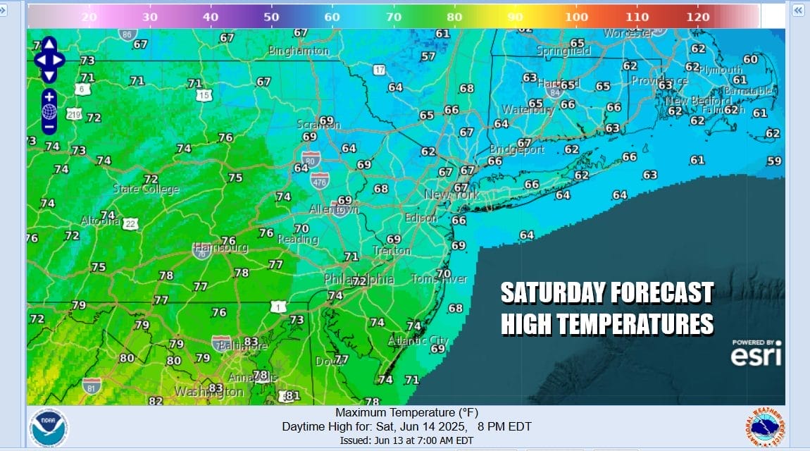
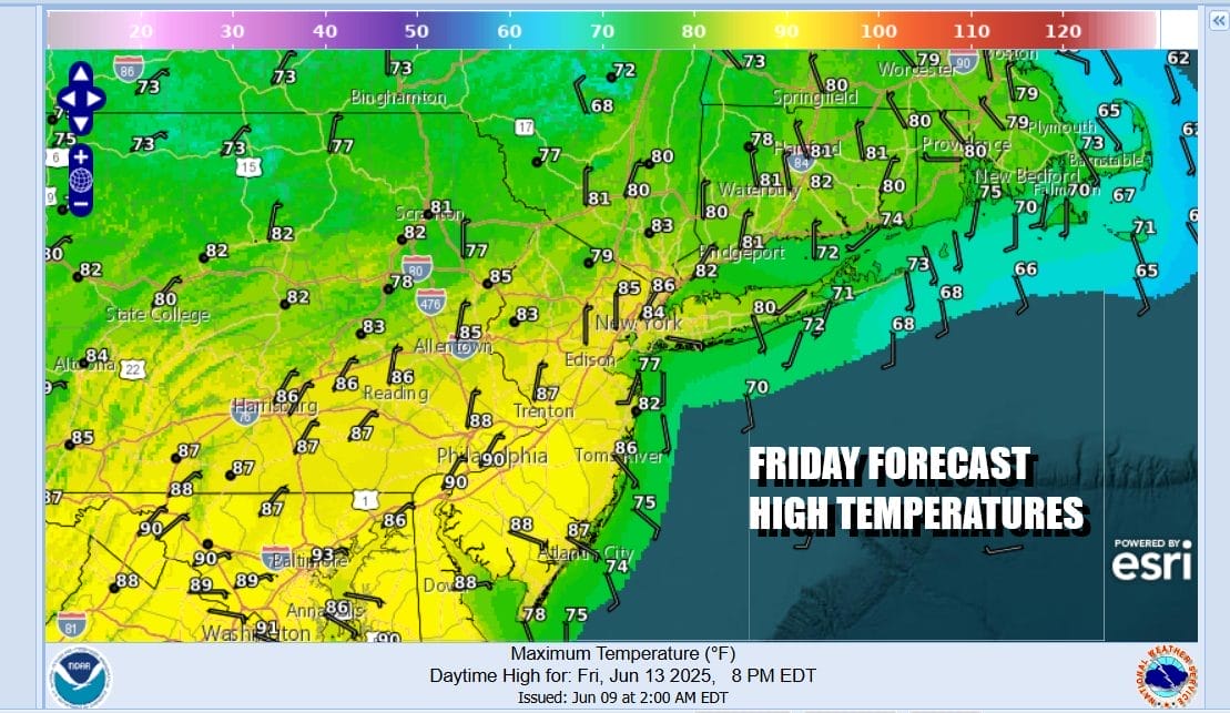
As far as Saturday is concerned, high temperatures might nudge above 70 degrees in some places, however temperatures will settle in the 60s while it is raining. The same holds for Sunday. With plenty of cloud cover and an east wind over the weekend temperatures are going to have a very tough time climbing above the 70 degree mark and again, when it is raining, temperatures will settle in the 60s.
The gloom and doom of the weekend and the curse of the onshore flow will continue Monday with lots of clouds and highs in the upper 60s and lower 70s. Some spotty light rain or drizzle is possible. The best chances for any steady rain is likely to be south across South Jersey and points southward. We may have to wait until later next week when weather fronts push through midweek and finally cause the onshore flow to break down. Happy Father’s Day to all the dads out there.
BE SURE TO DOWNLOAD THE FREE METEOROLOGIST JOE CIOFFI WEATHER APP &
ANGRY BEN’S FREE WEATHER APP “THE ANGRY WEATHERMAN!
MANY THANKS TO TROPICAL TIDBITS FOR THE USE OF MAPS
Please note that with regards to any severe weather, tropical storms, or hurricanes, should a storm be threatening, please consult your local National Weather Service office or your local government officials about what action you should be taking to protect life and property.


