
Easter Holiday Weekend Will Be Dry Most of the Time
Saturday Highs Reach 80 Degrees
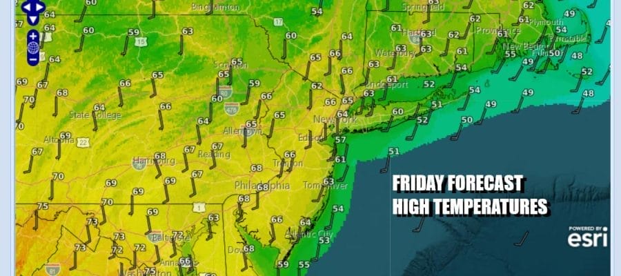
We have arrived at the doorstep of the Eastern Holiday weekend and it should be a good one overall for Eastern Pennsylvania to Southern New England. Low pressure is moving across the Great Lakes which has spun off from a frontal boundary that lies across the nation’s midsection. High clouds that are blowing from some showers and thunderstorms may move in later today but there should be plenty of sunshine in the mix. Highs today will be in the 60s though it will be a little cooler along the immediate coast thanks to a south wind.
SATELLITE WITH LIGHTNING STRIKES

WEATHER RADAR

A warm front will be going by to our north taking any showers well to the north and northeast overnight. High pressures settles off the Southeast US coast and that will produce more of a west wind tonight and Saturday. Over the weekend we have a frontal boundary from Michigan to Texas that will eventually sink southward late Saturday and Saturday evening but any showers and thunderstorms with that front will move into Pennsylvania and Western NY and gradually weaken as the move eastward Saturday.

This leaves Eastern Pennsylvania to Southern New England in a very good place for Saturday. You can expecet to see sunshine for most of the day along with a very warm west to southwest wind and that will warm things up considerably. Even the coast will see warm temperatures as the sea breeze will be kept at bay except for perhaps right on the coast itself. High temperatures Saturday will reach the mid to upper 70s near the coast and low or even a few middle 80s inland.

Inland areas might see a shower or thunderstorm Saturday evening as weather front passes but we expect any showers to weaken as they move east. The front will pass and move southward followed by high pressure that will build in during Easter Sunday. it will be about 15 degrees cooler for Sunday but it should be a partly to mostly sunny day with most highs in the 60s.

Next week will be a mostly dry week with the exception of perhaps Monday night when another front passes. There could be some scattered showers with its passage. During the day Monday we will have mostly cloudy skies with an onshore wind and highs mainly in the 60s. The rest of the week should be mainly on the dry side with at least some sunshine Tuesday through Thursday. Temperatures each day should reach the 70s and for a change, wind will not be a big issue.
BE SURE TO DOWNLOAD THE FREE METEOROLOGIST JOE CIOFFI WEATHER APP &
ANGRY BEN’S FREE WEATHER APP “THE ANGRY WEATHERMAN!
MANY THANKS TO TROPICAL TIDBITS FOR THE USE OF MAPS
Please note that with regards to any severe weather, tropical storms, or hurricanes, should a storm be threatening, please consult your local National Weather Service office or your local government officials about what action you should be taking to protect life and property.


