
Dry Weekend Colder Into Monday &
A Chance For A Burst of Snow Tuesday Morning

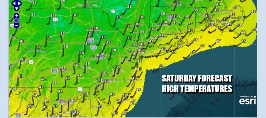
Our storm system of yesterday is gone, the wind advisories are down, and we can spend this Saturday in relative calmness after yesterday’s rough ride. We are in a fast flow of westerly winds in the upper atmosphere which means that weather systems continue to march along on a regular basis. Another strong storm system is taking a track similar to yesterday’s except this time around it will be weakening as it moves eastward rather than strengthening. It leaves us with no worse than partly sunny skies today with high temperatures mostly in the upper 30s and lower 40s. Radars are nice and quiet today.
SATELLITE WITH LIGHTNING STRIKES

WEATHER RADAR

The cold shot of air behind yesterday’s storm system was a quick one and we will be on the mild side tonight with some passing clouds. Most lows tonight will be in the upper 20s and lower 30s. Sunday a cold front approaches but a weak storm system means a weak cold front and there won’t be much with it other than clouds. West winds and some sunshine Sunday and high temperatures will be in the 40s.

A colder air mass follows the cold frontal passage Sunday which occurs with no precipitation. Skies clear out Sunday night and Monday should be a day of sunshine followed by the arrival of some late day clouds from the west. High temperatures Monday will be in the mid to upper 30s. Another fast moving system heads east Monday night with a trailing warm front to the west across the Great Lakes and Ohio Valley. That warm front is likely to have what I would describe as a stick of snow ahead of it and that stick will approach Eastern Pennsylvania to Southern New England early Tuesday morning.

A warm front is pushing into what is left of a cold air mass and sometimes in cases like this, you could wind up with a coating to a couple of inches of snow as the warm front goes by. It might end as a little rain or drizzle along the coast and these things usually don’t have much room for upside (you never know!). So we will go with what is being shown for now with the potential for a burst of snow Monday night into Tuesday morning mainly from Central New Jersey northward and northeastward into the Hudson Valley, Southern New New England and Long Island. Once the snow or rain ends we will have leftover clouds with highs in the 40s. Christmas Eve and Christmas Day look to be two dry days with no rain or snow issues at least through the dayside of Christmas Day. Highs both days will be in the 40s and skies should be no worse than partly sunny by day and partially clear Tuesday night and Wednesday night.
BE SURE TO DOWNLOAD THE FREE METEOROLOGIST JOE CIOFFI WEATHER APP &
ANGRY BEN’S FREE WEATHER APP “THE ANGRY WEATHERMAN!
MANY THANKS TO TROPICAL TIDBITS FOR THE USE OF MAPS
Please note that with regards to any severe weather, tropical storms, or hurricanes, should a storm be threatening, please consult your local National Weather Service office or your local government officials about what action you should be taking to protect life and property.


