
Colder Air Returns Tonight & Monday A Burst of Snow Early Tuesday Ends As Rain

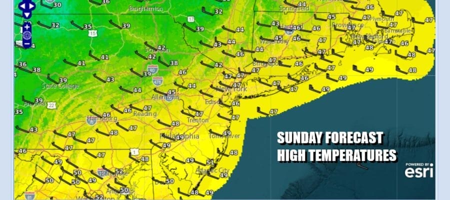
We have a mostly mild day ahead on this Sunday even though we have a cold front that will be passing through and may already have. The satellite loop shows very little in the way of moisture with this front. The colder air will wait for the upper trough to mass through later in the day. In the meantime we will see some sunshine, a west wind and high temperatures this afternoon that will reach the middle 40s before grinding to the halt and winds shift to the northwest later today into tonight. That starts the arrival of colder air. Locally radars are quiet today and we do not expect to see any precipitation as it stays mainly north in Upstate New York and and Northern
SATELLITE WITH LIGHTNING STRIKES

WEATHER RADAR

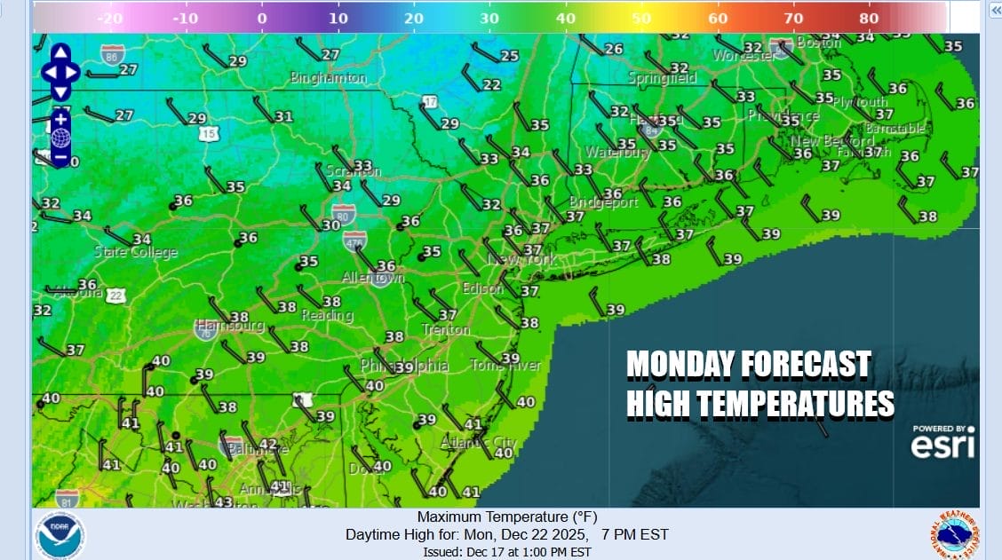
Most lows tonight under clear skies across Eastern Pennsylvania to Southern New England (including Long Island and New York City) will be in the 20s. Monday looks to be a nice day as cold high pressure sits overhead. We should see mostly sunny skies for much of the day and only late in the afternoon is when clouds start to come in from the west. Highs Monday will be in the upper 30s.
The weather pattern we have been in, is acting like an express train with weather system after weather system coming into the Pacific Northwest and then tracking straight eastward along the Canadian Border. The next in this series of storm systems will be moving east Tuesday tracking to the north into Southeastern Canada and then redeveloping off the coast of Eastern New England late Tuesday into Tuesday night.

A warm front extends from the low southeastward to the coast of Southern New Jersey and there will be what I would describe as perhaps a “stick” of snow that will develop north of that frontal boundary. Warm fronts can be tricky prospects. Occasionally they can surprise and put down a quick few inches of snow or more before they go by. This one may have the potential to surprise a little so we will be indicating that there will likely be a period of snow late Monday night into Tuesday morning across much of Eastern Pennsylvania to Southern New England.
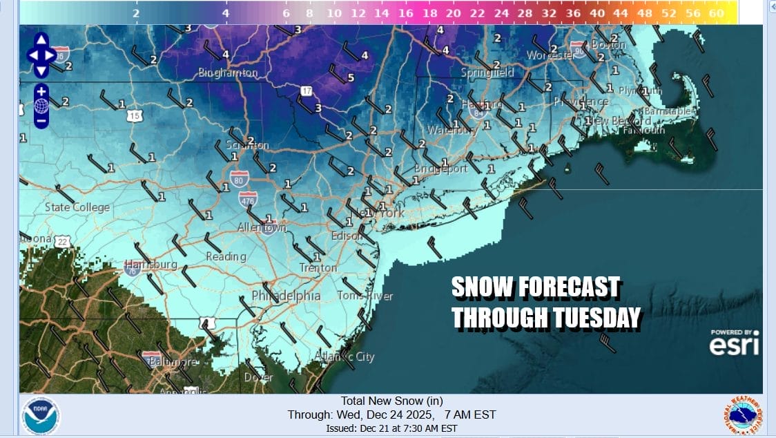
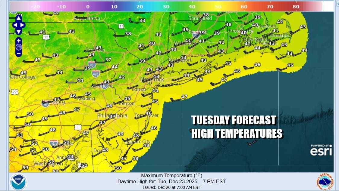
As far as accumulations are concerned, I think the best chance for perhaps an inch or two will be north of Interstate 78 in New Jersey and mostly north of Interstate 287 in Southeast New York and north of Interstate 95 in Connecticut. South of there over New York City, Long Island and coastal New Jersey we will allow for a bit of snow at the start and then going over to a little rain. Overall this does not look to be a big deal and it should be done by early afternoon. Tuesday temperatures will reach the 40s everywhere so even if it sticks, it melts.
Wednesday is Christmas Eve and we expect it to be a dry nice day with sunshine and highs in the 40s. There are no weather issues Wednesday night and you should be able to travel to and from whatever your destination happens to be. Christmas Day should be also a dry day with sunshine and some clouds with highs in the 40s. There may be the chance for some showers Friday as the next weather system moves along in the flow from west to east.
BE SURE TO DOWNLOAD THE FREE METEOROLOGIST JOE CIOFFI WEATHER APP &
ANGRY BEN’S FREE WEATHER APP “THE ANGRY WEATHERMAN!
MANY THANKS TO TROPICAL TIDBITS FOR THE USE OF MAPS
Please note that with regards to any severe weather, tropical storms, or hurricanes, should a storm be threatening, please consult your local National Weather Service office or your local government officials about what action you should be taking to protect life and property.


