
Cold Icy Day Ahead As Dry Air Slowly Arrives Rain Sunday Night & Later Monday As Temps Rise

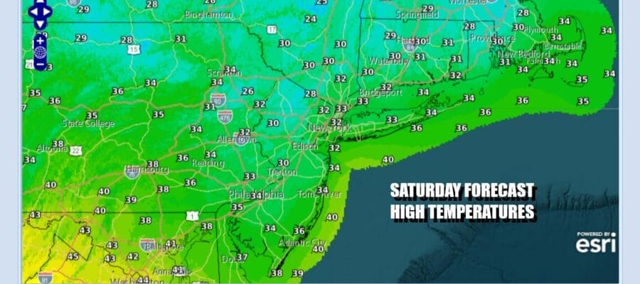
The overnight precipitation is mostly done and we still have icing issues across much of New Jersey where advisories will last until 10am. Then we have leftover clouds around along with some residual cold air from the storm system and the old high to the northeast. Temperatures today will have a tough time climbing above freezing in most places. Later in the day skies should start to clear and with clear skies and light winds tonight, you can look for some radiational cooling given the snow cover that is around. Most lows Sunday morning will be in the teens and low 20s. Cold spots inland and north and northeast of the urban areas could see lows drop to the single digits.
SATELLITE WITH LIGHTNING STRIKES

WEATHER RADAR

The next weather system is already going to be on our doorstep late Sunday afternoon. It comes in the form of an intensifying storm over the Northern Great Lakes that will move east and strengthen further across Southeastern Canada. A warm front approaches Sunday and ahead of this we will see clouds. There might be some rain that develops late in the day ahead of the warm front and it doesn’t amount to much. Some areas inland could see some freezing rain for a short time.

Ahead of the warm front Sunday we will see increasing clouds. Most highs will be in the 30s and some warmer spots could reach the upper 30s and lower 40s in South Jersey and Southeast Pennsylvania. Temperatures Sunday night will hold steady or even rise a few degrees as the warm front pushes into Upstate New York and New England.

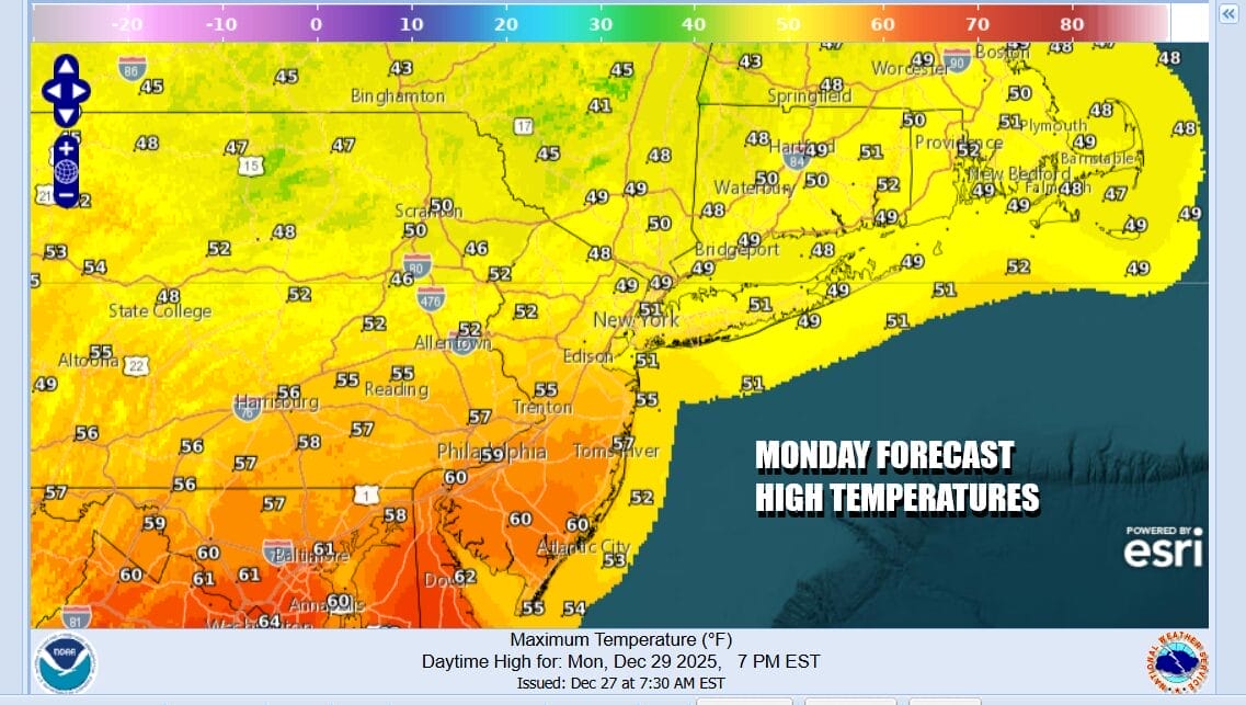
The cold front from this storm is going to pass during Monday and there might be a couple of showers with that but we do not expect to see much in the way of rain. Initially Monday will be on the warmish side with a southwest wind that shifts to the west and northwest. There will also be some clouds and sunshine in the mix. Temperatures Monday will rise into, and in some cases through the 50s before much colder air arrives.
By Tuesday morning temperatures will be in the 20s with strengthening northwest winds. Tuesday will be a windy and cold day with some sunshine but highs will just barely get back to the low and middle 30s. Winds could gust up to 40 mph at times and that will mean wind chills at least 10 degrees lower. Cold air continues into Wednesday with some sunshine and less wind for New Years Eve. Highs will be in the 30s. Another cold front will pass through Wednesday night into Thursday morning with cold air re-enforcements for New Years Day and beyond. For now the front comes through with only some scattered snow showers so unless there are more surprises in store, the week ahead should mostly be without any major snow or rain complications.
BE SURE TO DOWNLOAD THE FREE METEOROLOGIST JOE CIOFFI WEATHER APP &
ANGRY BEN’S FREE WEATHER APP “THE ANGRY WEATHERMAN!
MANY THANKS TO TROPICAL TIDBITS FOR THE USE OF MAPS
Please note that with regards to any severe weather, tropical storms, or hurricanes, should a storm be threatening, please consult your local National Weather Service office or your local government officials about what action you should be taking to protect life and property.


