
Cold First Weekend of January But Temperatures Moderate Next Week
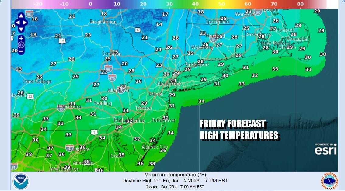
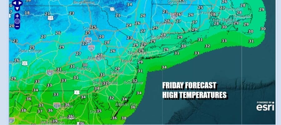
The New Year’s holidays are done and hopefully it was a good one for all of you. We find ourselves in cold air today thanks to a northwest flow. Radars are picking up on narrow bands of snow showers that are moving through some areas but not in others. Overnight we saw an area from the west come through leaving a dusting of snow in some places but again not necessarily in others. We will see clouds around this afternoon as the satellite loop shows those clouds streaming southeastward from the Great Lakes. Temperatures are on the cold side and most highs today will struggle in the upper 20s and lower 30s.
SATELLITE WITH LIGHTNING STRIKES

WEATHER RADAR

Passing clouds will continue tonight and we will leave in the chance for a passing snow shower. Most lows Saturday morning will be in the teens except near or just over 20 degrees in warmer urban locations. Saturday we watch low pressure develop off the Southeast US coast but this low is moving east and not north. There is another system in the northwest flow but the two systems stay separate.

We will take a slightly optimistic tone for Saturday and call for a mix of sun and clouds. Except for the coldest spots, most high temperatures should reach the low and middle 30s. Saturday night we will drop to the upper teens to mid 20s with some clouds around. Sunday should see some sunshine developing and once again, highs will reach the low and middle 30s in most places.

Next week we are going to a wholesale pattern change that will bring warmer temperatures and no risks for snow for awhile. A warm front will approach Monday with clouds and some snow but the snow part should go to our north and weaken as it heads across New York State and New England. Then we will be in a stretch of above average temperatures beginning Tuesday when highs return to the 40s. It will be warmer than normal but the amount of warmth will be limited due to the relative flatness of the building ridge in the Eastern US. Storm tracks look to be from the Plains to the Great Lakes and these farther west tracks will limit any rain changes going forward.
BE SURE TO DOWNLOAD THE FREE METEOROLOGIST JOE CIOFFI WEATHER APP &
ANGRY BEN’S FREE WEATHER APP “THE ANGRY WEATHERMAN!
MANY THANKS TO TROPICAL TIDBITS FOR THE USE OF MAPS
Please note that with regards to any severe weather, tropical storms, or hurricanes, should a storm be threatening, please consult your local National Weather Service office or your local government officials about what action you should be taking to protect life and property.


