
Chance For Showers Sunday First Accumulating
Snows Interior Northeast Likely Tuesday
The cold and windy holiday weekend rolls along but at least we will see the winds ease somewhat today as the pressure gradient relaxes and the core of the cold air move overhead in the form of high pressure. We still seeing some blow off clouds off Lake Effect snows around the Great Lakes but this should also lessen today and skies should be no worse than partly sunny. High temperatures today will be mostly in the upper 30s and lower 40s. We will have no rain or snow shower issues to worry about today or tonight. Most lows tonight will be in the 20s except for warmer urban areas will bottom in the lower 30s.
SATELLITE WITH LIGHTNING STRIKES

WEATHER RADAR

Across the Midwest today from the Upper Ohio Valley to the Great Lakes we are seeing a major snow storm with one foot plus snows common place from Iowa to Illinois, Indiana, Michigan, Wisconsin, and Northwest Ohio. Widespread winter storm warnings are posted in these states making for a rather sizeable Thanksgiving weekend snowstorm. This low will track through the Great Lakes into Southeastern Canada Sunday.

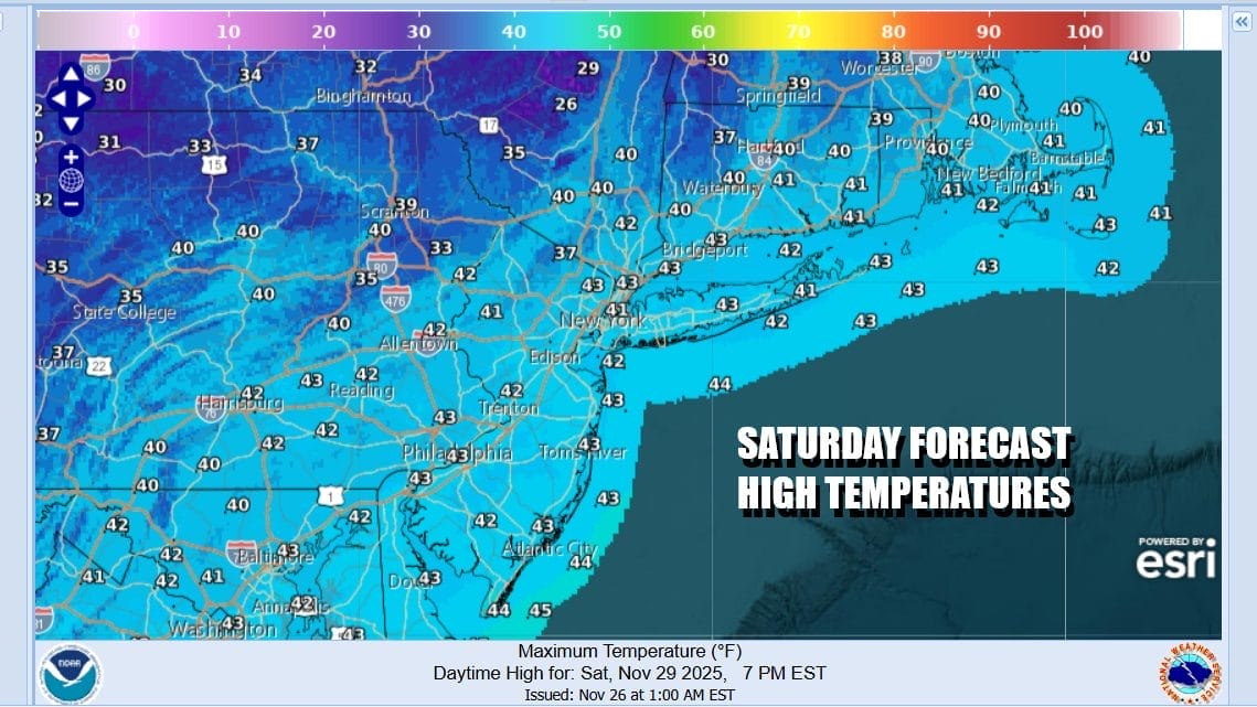
Showers from this front will be moving through from late morning to late afternoon Sunday across Eastern Pennsylvania to Southern New England. These will be more of a nuisance than anything else as we do not expect much rain from this cold front. Otherwise Sunday will be cloudy and it will be milder as high temperatures reach the upper 40s and lower 50s in most locations.

We will see improving weather conditions behind this cold front but temperatures will trend lower as colder air builds in for Monday. We expect to see sunshine but most highs Monday will be in the lower 40s. The cold front from Sunday stalls across the Deep South and you will see low pressure develop and head eastward into the Appalachians and then eventually off the Mid Atlantic coast Tuesday and Tuesday night. With cold air in place we will likely see some snow develop Tuesday morning in many areas including briefly at the coast.

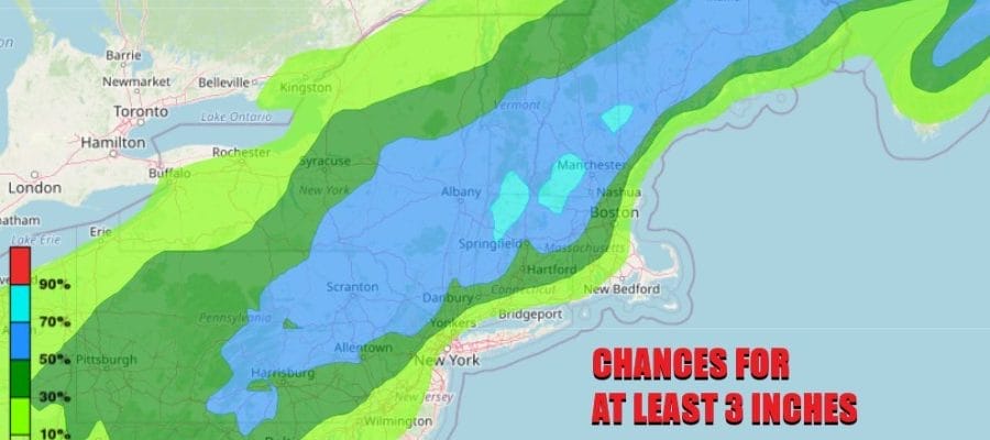
Low track and the amount of cold air suggest this could be the first important snowfall for the interior areas of the Northeast and Mid Atlantic states of the season. The Weather Prediction Center is indicating a 30 percent chance or higher for at least 3 inches on a line just north and west of Philadelphia and New York City and a greater than 50 percent chance for at least 3 inches from Northeast Pennsylvania and Northwest New Jersey and then along and north of the Interstate 84 corridor in New York and Connecticut. It does seem it will be warm enough for mostly rain in the big cities but the boundary for colder air is not that far away. We will see how important the cold air than builds in Monday will be for this storm system. It does seem areas well inland have the potential for a 6 inch plus snowfall. We will monitor the situation closely in the coming days.
BE SURE TO DOWNLOAD THE FREE METEOROLOGIST JOE CIOFFI WEATHER APP &
ANGRY BEN’S FREE WEATHER APP “THE ANGRY WEATHERMAN!
MANY THANKS TO TROPICAL TIDBITS FOR THE USE OF MAPS
Please note that with regards to any severe weather, tropical storms, or hurricanes, should a storm be threatening, please consult your local National Weather Service office or your local government officials about what action you should be taking to protect life and property.


