
Calm Weather Through Wednesday
Storm Threat Mostly Gone For Late Week
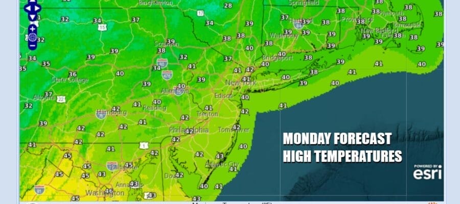
The work week begins with a cold start but temperatures should recover somewhat back to the upper 30s and lower 40s this afternoon. We continue to see systems moving along in the northwest flow from Canada and this will be enhanced as the week moves along. Shots of cold air will be coming down separated by cold fronts and low pressure areas that mostly go by to our north. Skies today should be partly to mostly sunny and radars will be relatively inactive. Winds will be lower today but they will still be gusting into the 20 to 25 mph zone at times.
SATELLITE WITH LIGHTNING STRIKES

WEATHER RADAR

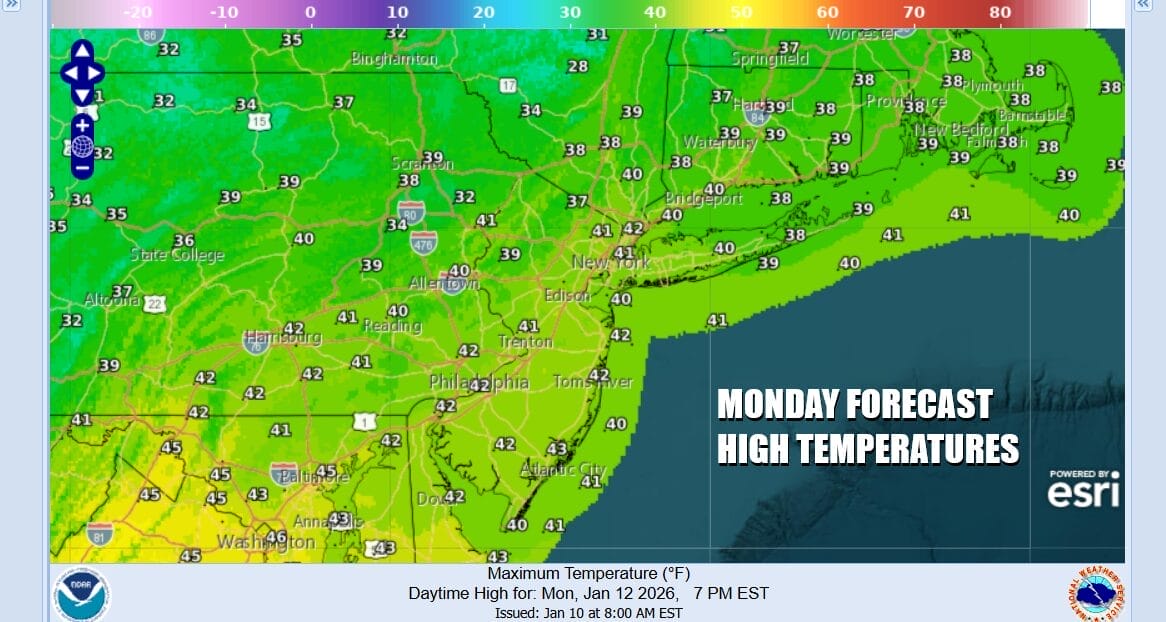
Tonight we will see mainly clear skies with nothing more than some passing clouds. Most lows by Tuesday morning will be in the 20s to around 30 degrees. Tuesday we will have a west to southwest wind and a good deal of sunshine and that should take highs up to the low and middle 40s.
Weather models late last week and into this weekend were indicating that we could see an arctic boundary approaching Wednesday which would then lead to storm development off the Mid Atlantic coast. That is not going to happen. Instead low pressure will develop to our north in Upstate New York and eventually redevelop in the Gulf of Maine. For Eastern Pennsylvania this is going to play out as a simple cold front that will pass through Wednesday night.

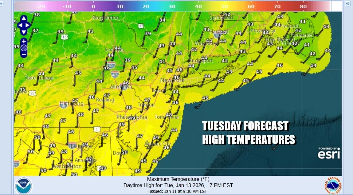
Ahead of all this Wednesday we will have some sunshine giving way to arriving clouds. It will be warming up through the 40s and even reach 50 or better in some places in South Jersey and Southern Pennsylvania. We will probably see some showers in Pennsylvania Wednesday afternoon and they may inch to the coast Wednesday evening as the front draws closer.
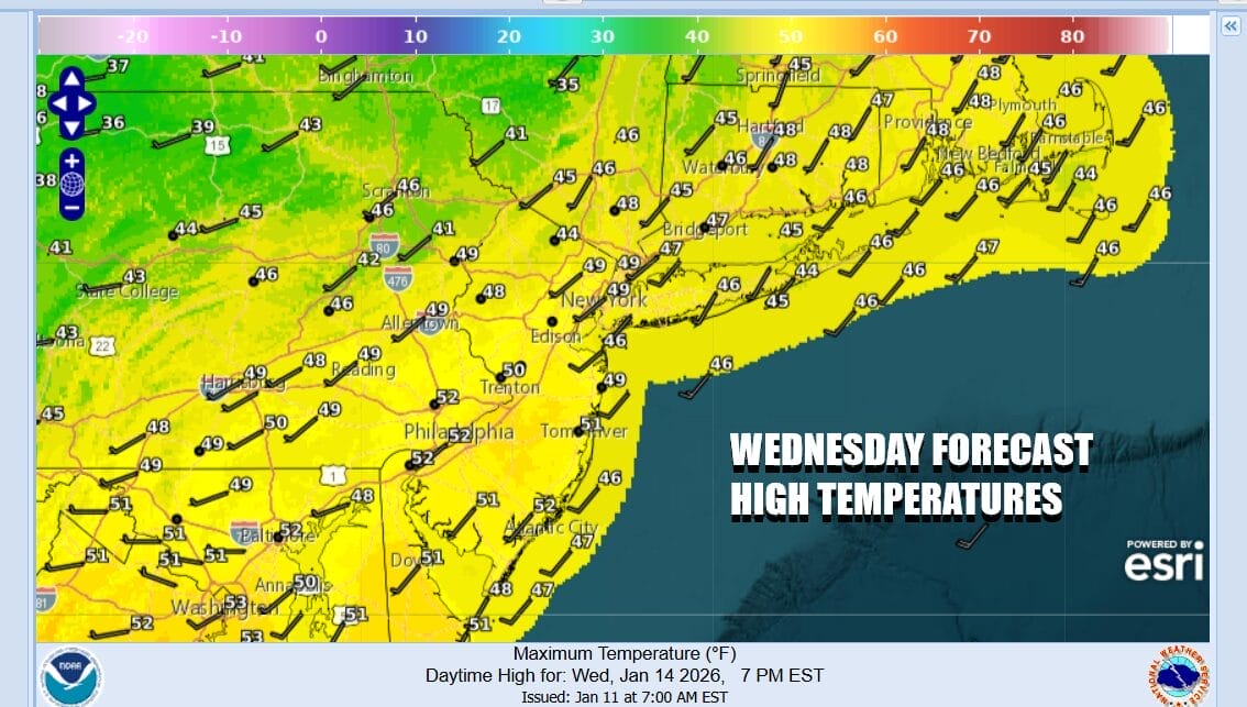
There could be a little bit of wave development on the front. That might extends the precipitation on the backside of the cold front southward early on Thursday and there could be a little mixing or a brief change to snow before this all ends Thursday morning but it will not amount to anything important. Cold unstable air and an upper trough could set off some snow showers Thursday afternoon. Temperatures will be settling in the 30s Thursday and Friday will be cold with some sunshine. Highs just in the upper 20s and lower 30s. Another arctic boundary approaches over the weekend and it could another wash rinse repeat scenario.
BE SURE TO DOWNLOAD THE FREE METEOROLOGIST JOE CIOFFI WEATHER APP &
ANGRY BEN’S FREE WEATHER APP “THE ANGRY WEATHERMAN!
MANY THANKS TO TROPICAL TIDBITS FOR THE USE OF MAPS
Please note that with regards to any severe weather, tropical storms, or hurricanes, should a storm be threatening, please consult your local National Weather Service office or your local government officials about what action you should be taking to protect life and property.


