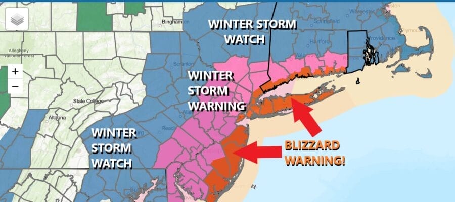

Blizzard Warnings & Winter Storm Warnings
Posted For Heavy Snow & Strong Winds
Blizzard Warnings & Winter Storm Warnings
Posted For Heavy Snow & Strong Winds
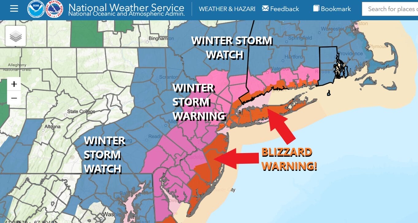
Blizzard Warnings are posted for the coastal counties of New Jersey, New York City, Long Island, Southern Westchester, & Coastal Connecticut with Winter Storm Warnings further inland into Southeastern Pennsylvania, Delaware, the Hudson Valley and interior Connecticut. Strong winds especially long the coast will gust to 50 mph or Sunday night and Monday as this major storm impacts the Northeast and Northern Mid Atlantic states.
I’m pretty much in line with the National Weather Service snow forecast amounts. Basically up to a foot or a foot and a half is possible along the coast where Blizzard Warnings are up and lesser though sizeable amounts are forecast for inland areas. Further west and southwest amounts do drop off and there will likely be a sharp cut off from heavy snow to far less setting up somewhere across the region. Some models continue to produce unheard of amounts but we think these numbers from the National Weather Service are reasonable.
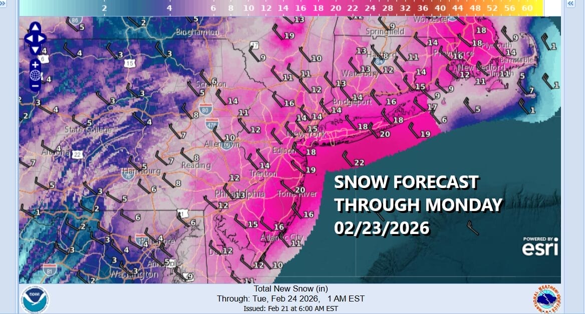
The tricky part of this forecast as the western edge is going to sharply cut off somewhere near you so low track matters. Model spreads from west to east are down to about 30 to 40 miles with the GFS and NAM further west and the European & Canadian models a little to the east so any shift west or east will determine whether numbers are too high or too low especially for the western and northwest flank of the snow shield.
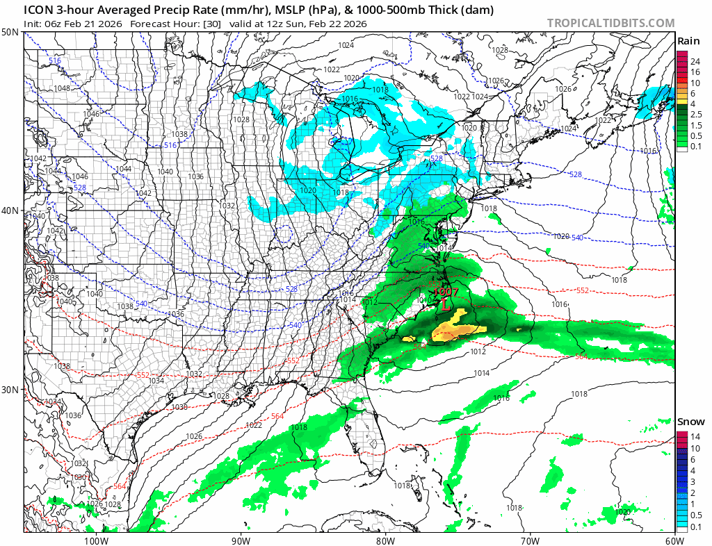
SATELLITE WITH LIGHTNING STRIKES

WEATHER RADAR

We have no weather issues to worry about today into Sunday morning. Clouds will be around today as the atmosphere primes up though there will be some breaks of sunshine in the mix. Most highs will reach the 40s. Then tonight clouds will increase from south to north with lows in the low to mid 30s. Snow will begin to overspread the area during the day Sunday. In Central and South Jersey (south of Interstate 195) it will probably start as light rain but after 4pm, it changes to snow and starts to come down heavier. The heaviest snow will fall Sunday night into the first part of Monday morning and then end from west to east Monday afternoon. Snow from NYC to Long Island and Connecticut will probably last into early evening as some backside patches remain. Once it starts to snow hard, temperatures will fall to between 29 and 31 and likely stay inside that tight range. This will be a heavy wet snow as opposed to the powdery snow from January’s storm and there is little or no sleet involved with this storm.
Strong winds will gust to 50 mph or more along the coast and there could at the very least moderate coastal flooding issues at high tide. In addition we still have partially frozen back bays and coupled with the tide and the wind, we could see patches of ice being jammed up into the shoreline and this could cause structure damage along with damage to the coastline itself so coastal residents should be alert to this possibility. We will be doing a special Joe & Joe Weather Show podcast on Youtube tonight at 7:30pm
BE SURE TO DOWNLOAD THE FREE METEOROLOGIST JOE CIOFFI WEATHER APP &
ANGRY BEN’S FREE WEATHER APP “THE ANGRY WEATHERMAN!
MANY THANKS TO TROPICAL TIDBITS FOR THE USE OF MAPS
Please note that with regards to any severe weather, tropical storms, or hurricanes, should a storm be threatening, please consult your local National Weather Service office or your local government officials about what action you should be taking to protect life and property.


