
Blizzard Warnings Snow Amounts Raised
Eastern Pennsylvania to Southern New England
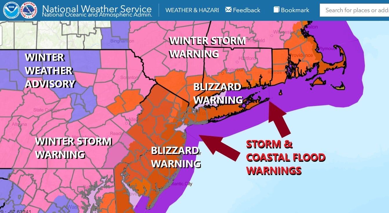
Blizzard warnings are up and expanded to cover all of Delaware, Eastern Maryland, New Jersey, 2 counties in Northeast Pennsylvania and the counties in Southeast Pennsylvania, the Lower Hudson Valley south of Interstate 84, the southern half of Connecticut, Rhode Island and Eastern Massachusetts including Cape Code. This the first time ever in National Weather Service history that all of the state of New Jersey is under a blizzard warning. Winter Storm Warnings extend northward into the middle Hudson Valley, much of Pennsylvania, Northern Connecticut into the remainder of Massachusetts, Central and Eastern Maryland into Northern Virginia.
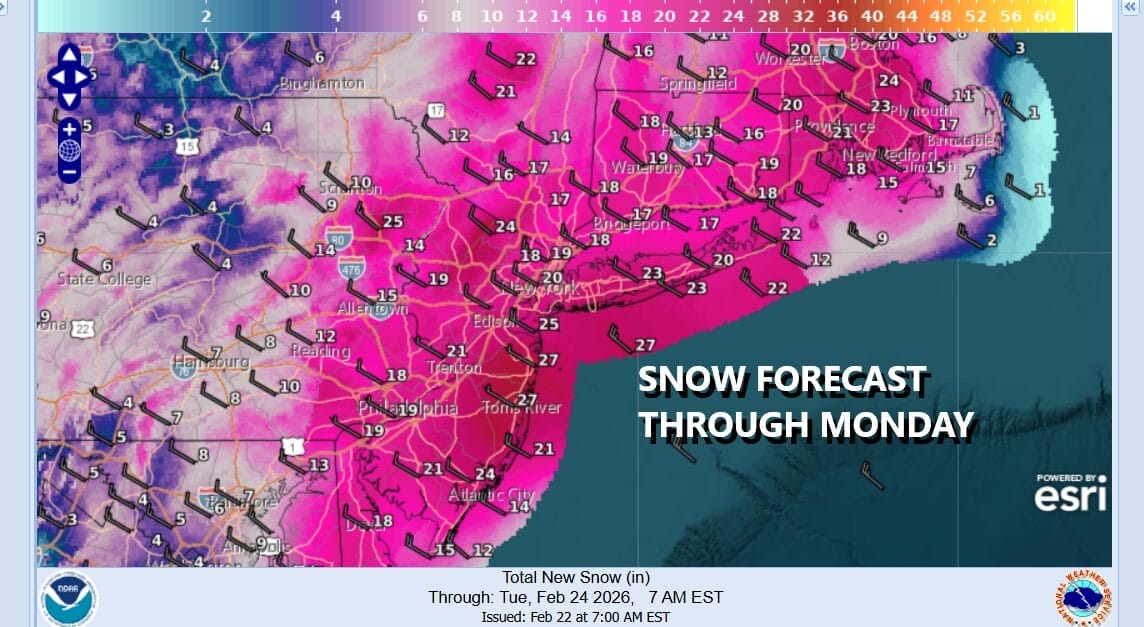
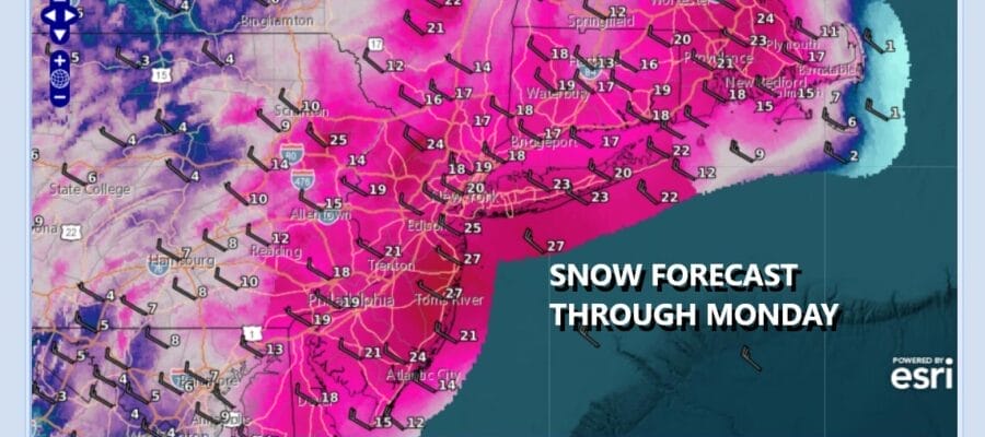
A potentially historic winter storm is getting underway. Everything is lined up in the atmosphere. Our coastal low is intensifying rapidly. Snow amounts have been increased on both my forecast and the National Weather Service snow forecast. 2 feet or more is forecast to fall in the coastal counties from New Jersey to Long Island and Southeast New England when it is all said and done. 1 to 2 feet to the west into Eastern Pennsylvania with lower amounts further west and north. Models remain remarkably consistent and even the laggards have woken up and joined the party.
SATELLITE WITH LIGHTNING STRIKES

WEATHER RADAR

The strong upper air feature driving all this is diving into position. Precipitation is breaking out quickly across the Mid Atlantic and northeast. Into early afternoon we will have light rain or in some cases a mix of rain and snow that won’t amount to much. Then as the intensity of the precipitation increases this afternoon, rain changes over to snow across Eastern Virginia, Maryland and Delaware and by late afternoon snow will be falling steadily across much of Eastern Pennsylvania to Southern New England.

Heavy snow falls tonight into Monday morning across Eastern Pennsylvania to Southern New England including all the major cities like Philadelphia, New York City to Hartford, Providence and eventually Boston. Snowfall rates will vary from 1 to 3 inches an hour or even more. Heavy snow Monday morning will begin to very slowly taper off but in areas from New Jersey to Southern New England, snow will continue with varying intensity into the early evening hours before finally coming to an end.
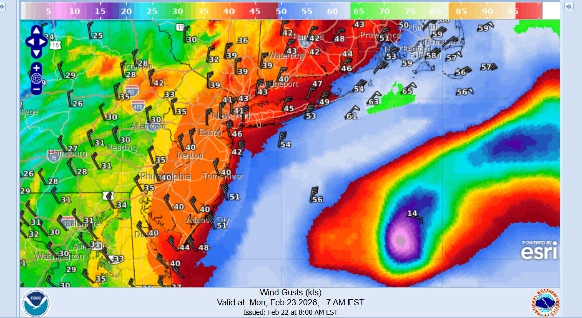
The definition of a blizzard is winds in excess of 35 mph or more and visibility under a quarter of a mile for at least 3 hours and this definition will certainly be met. Winds are going to become strong overnight with gusts over 40 mph inland and gusts of 50 to 60 mph possible along the immediate coast. Coastal flood warnings are in effect for moderate coastal flooding in many areas at high tide. The strongest winds will be from midnight tonight through midday Monday. We will be of course doing video updates of Weather in a Minute as well as live Joe & Joe Weather Show Podcasts. Stay tuned for specific times on my youtube channel.
BE SURE TO DOWNLOAD THE FREE METEOROLOGIST JOE CIOFFI WEATHER APP &
ANGRY BEN’S FREE WEATHER APP “THE ANGRY WEATHERMAN!
MANY THANKS TO TROPICAL TIDBITS FOR THE USE OF MAPS
Please note that with regards to any severe weather, tropical storms, or hurricanes, should a storm be threatening, please consult your local National Weather Service office or your local government officials about what action you should be taking to protect life and property.


