
Bitter Cold Week Ahead Into Next Weekend
Another Storm Risk Possible Next Weekend
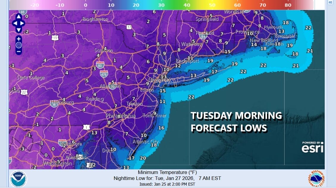
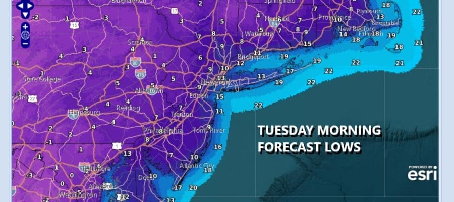
Our snow sleet storm is done and now the next item on the weather agenda will be bitter cold temperatures that will be with us all week long. Arctic air mass after arctic air mass will be dropping southeastward out of Canada and each one will simply re-enforce the below average temperature pattern that we have been in for much of this winter. Today will be a day of clouds and some sunshine. The upper trough that produced the East Coast storm this weekend is playing through today and there could be some scattered snow showers around. Most highs today will be in the upper 20s to around 30 degrees which, by the way, makes today the warmest day of the week. By morning under clear skies, lows will be in the single digits to lower teens under mainly clear skies.
SATELLITE WITH LIGHTNING STRIKES

WEATHER RADAR

Tuesday through Friday we will be in an arctic air mass as high pressure drops southeastward from Central Canada and this high will only be followed by another late in the week. This actually simplifies the forecast where we will see sunshine and some clouds today with highs only in the upper teens and lower 20s.
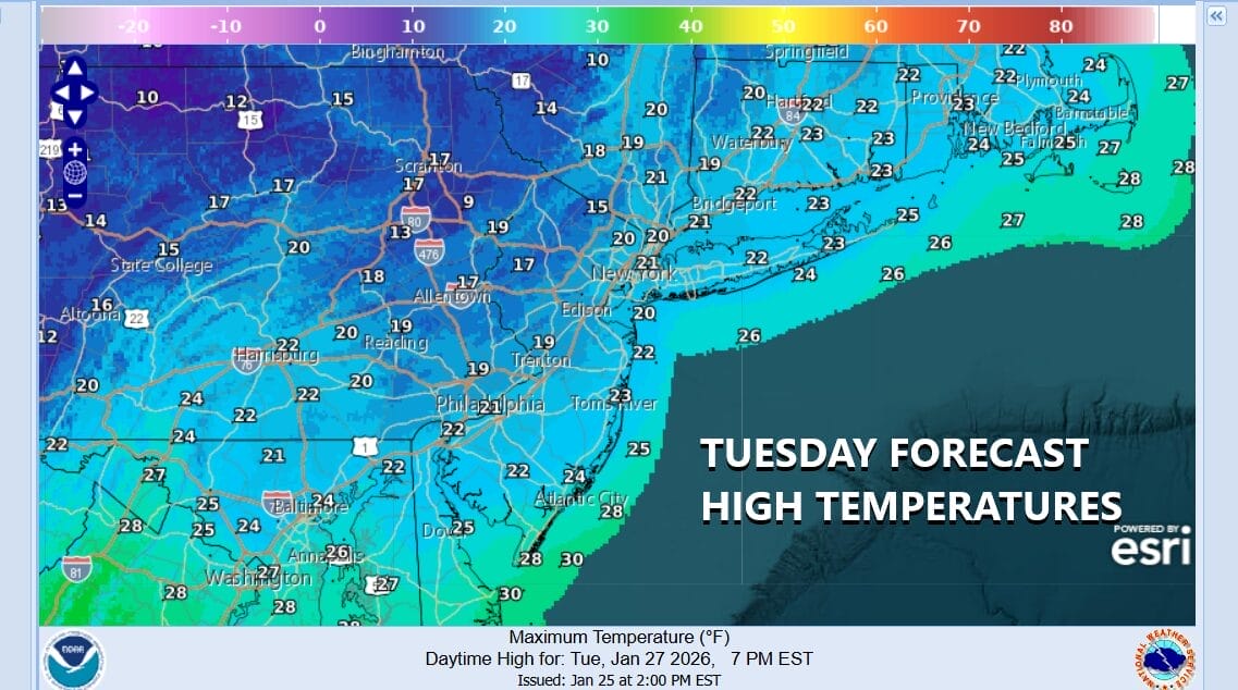
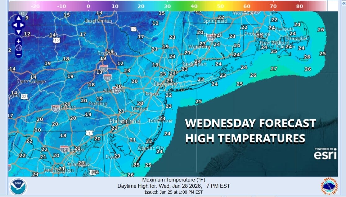
Tuesday night into Wednesday morning we will see temperatures drop to the single digits to near 10 above for lows. Wednesday we are looking at some sunshine again but once again it will be very cold with most highs just in the upper teens to barely back to 20 degrees. The same will hold for Thursday right into the start of the weekend.
We noted before the weekend major winter storm that when all the models have something, it is probably worth paying attention to. Such is the case for this coming weekend. All the models overnight including their AI counterparts are showing the development of a major storm of the East Coast. This means there is a higher probability of something happening. This storm will be triggered by a diving upper air trough and another brutally cold arctic air mass behind it.

Since this is for the upcoming weekend, it is not exactly far out in the long range so it might be that the models are indeed up to something. For this is a lets watch situation going forward. We can say that the pattern of well below average temperatures will continue regardless of storm in development. We can also say that snow basically begets more snow and it would not be a shock if we wind up with another major storm to deal with this coming weekend. We can all hope that it just goes away.
BE SURE TO DOWNLOAD THE FREE METEOROLOGIST JOE CIOFFI WEATHER APP &
ANGRY BEN’S FREE WEATHER APP “THE ANGRY WEATHERMAN!
MANY THANKS TO TROPICAL TIDBITS FOR THE USE OF MAPS
Please note that with regards to any severe weather, tropical storms, or hurricanes, should a storm be threatening, please consult your local National Weather Service office or your local government officials about what action you should be taking to protect life and property.


