

Best Weather Day of the Week
Rain Friday Night Saturday Colder Sunday

Today sets up to be the weather day of the week. High pressure is settling in the Middle Atlantic states and other than some patchy low clouds that are leftover from overnight, they will burn away quickly and today should be a day of sunshine. Winds will behave except for local sea breezes that will develop along the New Jersey coast and over Long Island. Most highs this afternoon away from ocean locations will be in the upper 40s and lower 50s. Radars are nice and quiet and should remain so in to the first part of Friday.
SATELLITE WITH LIGHTNING STRIKES

WEATHER RADAR

While the East remains quiet and calm we are seeing action to the west as the next 2 weather systems make a run to the east and north over the next few days. The first low pressure area runs from Kansas to the Great Lakes today and tonight and with that we have a cold front that will be approaching Friday. This low takes a track far enough west that moisture with it is going to be rather limited.

The front might set off a few showers late Friday into Friday night but the rain should not amount to much. Then we get a break as the front drops southward, stalls across Virginia back to the Gulf States where a second storm system develops in Southeast Texas and eventually finds its way to the Appalachians. This low will both Gulf of America and Atlantic moisture with it and the old cold front becomes a warm front and heads back northward Saturday.
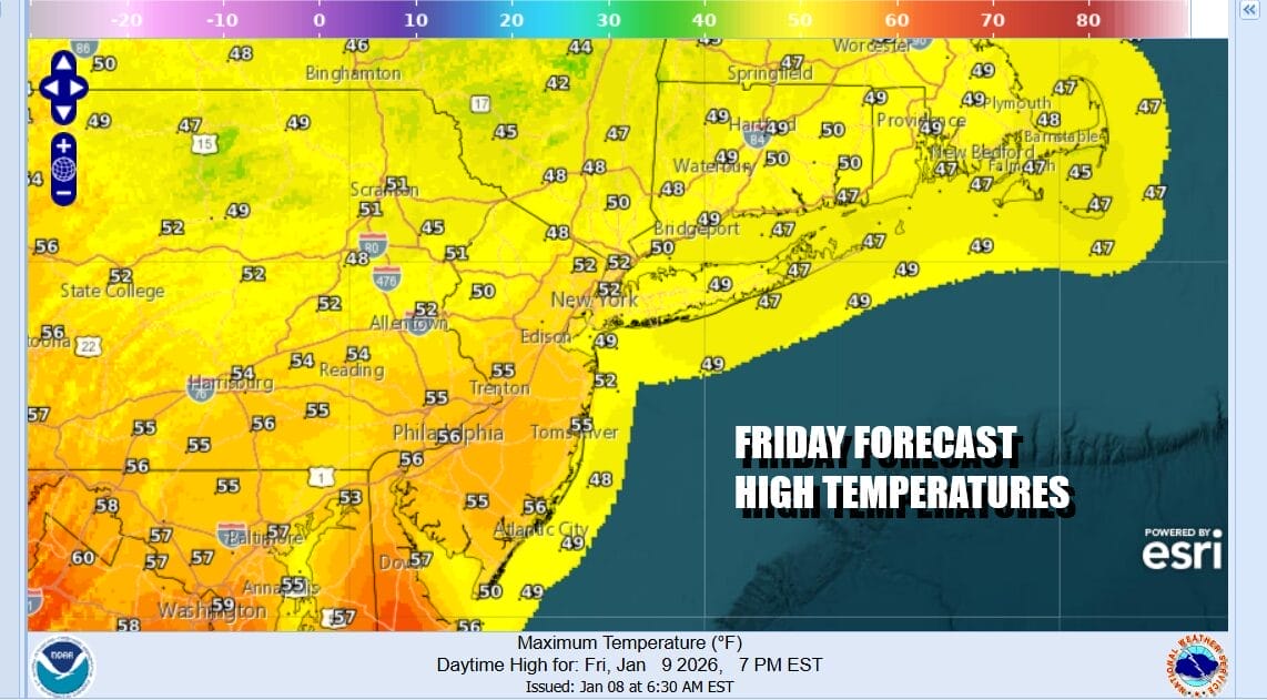
Ahead of the cold front Friday we will have sunshine giving way to arriving clouds and the risk for late day and evening showers. Highs will bein the 50s except right along the immediate coast where the south wind will keep things cooler. Showers go in and out Friday night and then the second low comes into play Saturday. Rain develops from south to north during the day though the morning could be dry. Rain will continue into Saturday night until the low goes by to the west and a cold front passes through.

Saturday temperatures could reach the mid 50s to near 60 degrees before the front passes offshore. Then colder air returns Sunday with some developing sunshine. The highs for the day will be in the 50s and that will likely be during the early morning hours Sunday before the front moves off shore. Temperatures during the day Sunday will settle in the 40s and not move very much and then down into the 20s by Monday morning. Rainfall amounts should be in a range of 3/4 inch to an inch or so in most places.
BE SURE TO DOWNLOAD THE FREE METEOROLOGIST JOE CIOFFI WEATHER APP &
ANGRY BEN’S FREE WEATHER APP “THE ANGRY WEATHERMAN
MANY THANKS TO TROPICAL TIDBITS FOR THE USE OF MAPS
Please note that with regards to any severe weather, tropical storms, or hurricanes, should a storm be threatening, please consult your local National Weather Service office or your local government officials about what action you should be taking to protect life and property.


