

Back to Sunshine & Warmish Temperatures Into the Weekend

We never were really enthused about the idea of rain yesterday and sure enough almost all of it remained offshore. When you are in a persistent weather pattern, it is better to let the trend be your friend until proven otherwise. We go with the trend of sunshine and dry. Temperatures today will warm up to the upper 70s to around 80 degrees which is a little bit above the average for this time of year but not by much. Satellite and radar views show no rain and mainly clear skies up and down the East Coast (except for South Florida) and west to the Ohio and Tennessee Valley. Skies today will be mostly sunny most of the time!
SATELLITE WITH LIGHTNING STRIKES

WEATHER RADAR

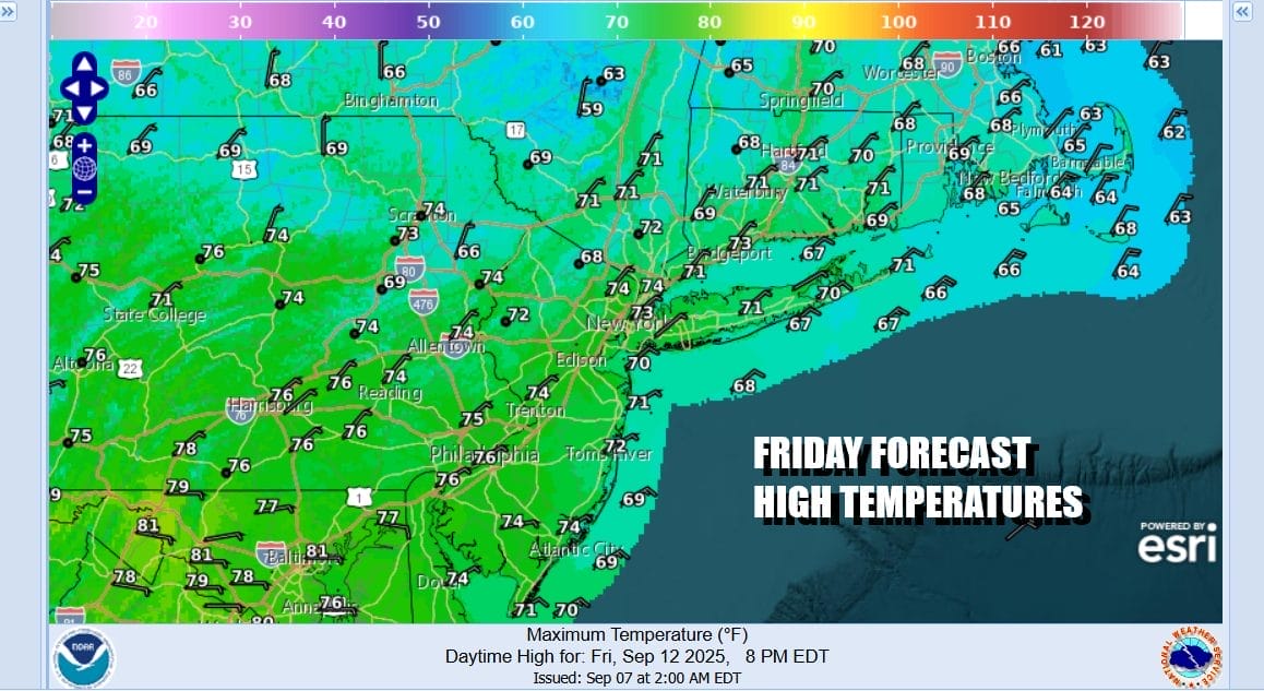
Not much is going to change through Sunday morning at least. Skies tonight will be mainly clear with lows in the 40s for the coolest locations inland. Mostly 50s to around 60 degrees will be common everywhere else. Friday looks to be partly to mostly sunny with high temperatures mostly in the 70s though it will be a little cooler along south and east facing shorelines.
Moving into the weekend I think there is chance that we can get through it with no rain or at worst, a minimal amount of rain. The flow off the ocean could bring in some clouds and maybe a little drizzle during the late night and early morning hours as this is the nature of weather this time of year with shorter days and longer nights. High pressure holds into Sunday morning before it gives way to another cold front.

This front is dropping southward from Upstate New York and Eastern Canada so there isn’t going to be much to it other than clouds and maybe a shower or two scattered about. Models keep backing off on a more showery type of day and this is probably the right way to approach the forecast. Saturday will be no worse than partly sunny with highs in the 70s. Cooler temperatures will prevail along south and east facing shorelines.

Morning low clouds and patchy drizzle should give way to partly sunny skies Sunday. We will throw in the chance that there could be a scattered shower or two late in the day or into Sunday night. High temperatures on Sunday again will be mostly in the 70s except again cooler along south and east facing shorelines.

The dry weather pattern continues next week and we may go through the entire week without rain. Another high builds into New England and Eastern Canada so winds from the northeast and east will prevail. Warmer inland and cooler coast will be the rule. Temperatures will be close to seasonal or only slight above average. We will monitor lower pressures off the Southeast Coast during the week for a possible low forming and perhaps moving northward but this is in the speculative phase of the forecast range.
BE SURE TO DOWNLOAD THE FREE METEOROLOGIST JOE CIOFFI WEATHER APP &
ANGRY BEN’S FREE WEATHER APP “THE ANGRY WEATHERMAN!
MANY THANKS TO TROPICAL TIDBITS FOR THE USE OF MAPS
Please note that with regards to any severe weather, tropical storms, or hurricanes, should a storm be threatening, please consult your local National Weather Service office or your local government officials about what action you should be taking to protect life and property.


