
Another Chilly Day But Clouds & Showers On the Way Saturday Night
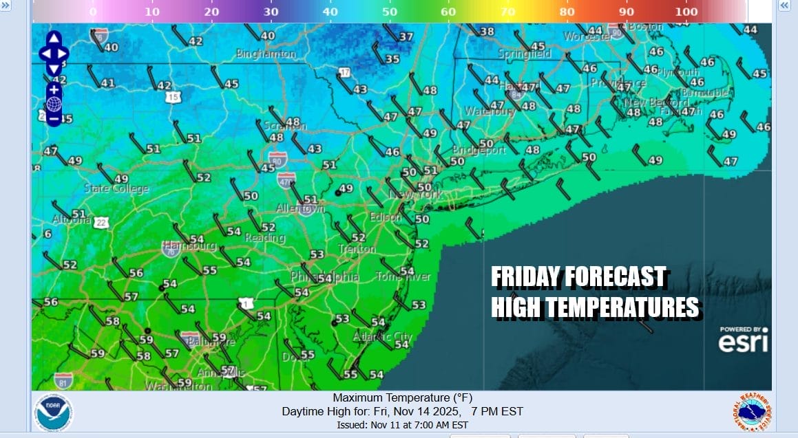
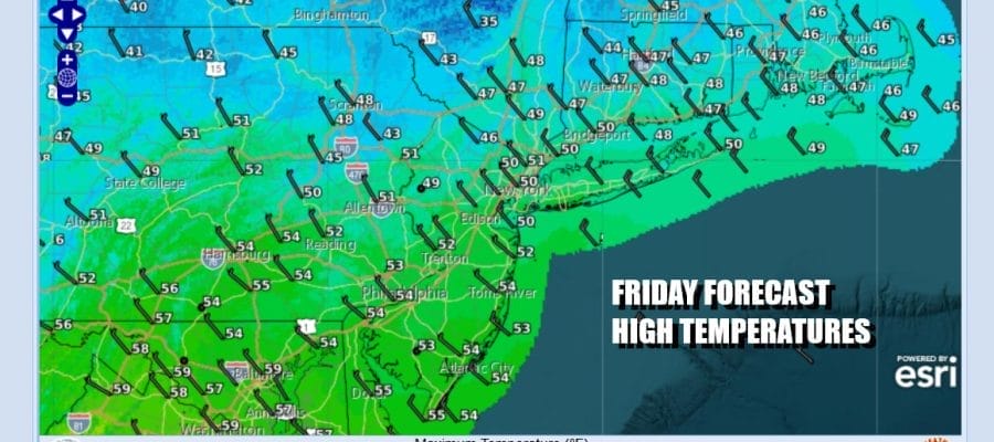
We have arrived once again at the doorstep of the weekend. The northwest flow continues across the Northeast so while everyone else to the west and south is warming up some, in the Northeast US the warmup will be very brief and unremarkable. Certainly we are not seeing such a warm up today though we will be no worse than partly sunny on this Friday. Winds will continue to ease slowly but will whip up on occasion. High temperatures this afternoon will be in the upper 40s and lower 50s. Satellite loops are showing fewer clouds than what we have seen in the last few days and the radars are more on the quiet side.
SATELLITE WITH LIGHTNING STRIKES

WEATHER RADAR

Over the weekend we are setting up for the arrival of low pressure that is heading across Southeastern Canada with a trailing warm front and cold front extending southward. It appears that the risk for showers will occur Saturday night meaning that the dayside of Saturday and Sunday should be mostly dry. Lead showers will arrive with the warm front during the evening hours.

The warm front passes and it is quickly followed by the cold front and that should bring an end to the showers before daybreak Sunday. Behind the front we will see a resumption of colder air but this time around, unlike earlier in the week, the cold air mass will extend southward to the Middle Atlantic states and not all the way south to Florida and all the way west to the Mississippi River Valley.
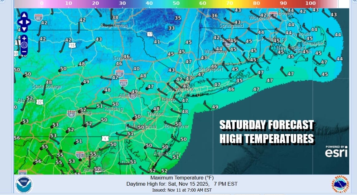
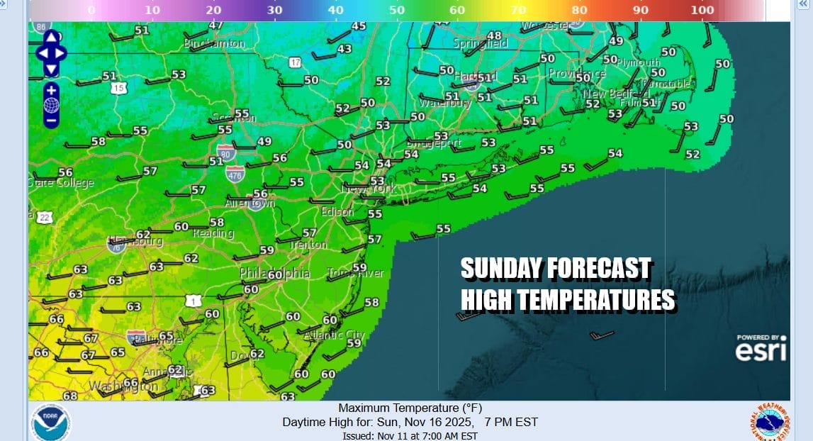
Breaking all this down, Saturday might start with some sunshine but clouds will increase rather quickly. The could cover will hold the temperatures down and highs will be in the upper 40s and lower 50s. We might see temperatures actually rise some Saturday night as the showers come and then go out by daybreak. Sunday we will see the reverse of Saturday as clouds will give way to sunshine, a gusty northwest wind will develop. Temperatures Sunday will top out mostly in the mid 50s to around 60 degrees or so in warmer locations as you head south.
Next week we will see dry weather for much if not all of the work week. There is a weather system coming out of the Plains that will move straight east and pass off the Mid Atlantic coast & weakening along the way. The next weather system of consequence will probably come next weekend in the form of a strong cold front and the risk showers and maybe even a rumble or two of thunder for next weekend. Temperatures next week will start out below average for this time of year and then nudge back to near average later in the week.
BE SURE TO DOWNLOAD THE FREE METEOROLOGIST JOE CIOFFI WEATHER APP \\\&
ANGRY BEN’S FREE WEATHER APP “THE ANGRY WEATHERMAN!
MANY THANKS TO TROPICAL TIDBITS FOR THE USE OF MAPS
Please note that with regards to any severe weather, tropical storms, or hurricanes, should a storm be threatening, please consult your local National Weather Service office or your local government officials about what action you should be taking to protect life and property.


