
A Weekend of Sunshine, Chilly Temperatures No Rain Through At Least Monday

This is the last weekend for the month of October and it will be going out nicely. We have not real weather issues in the Northeast and Middle Atlantic states today as high pressure in Eastern Canada will be driving our weather for the next 3 or 4 days. Other than some passing clouds in a more stable atmosphere, skies today will be no worse than partly sunny. Most highs this afternoon will be in the upper 50s to some lower 60s. Radars are nice and quiet and will remain so for the remainder of the weekend and into early next week. Nights will be getting a little colder with skies tonight being mainly clear and lows will be in the low to mid 40s coast and warmer urban areas, 30s inland and 20s in some cold spots well inland and north.
SATELLITE WITH LIGHTNING STRIKES

WEATHER RADAR

The downtrend in temperatures will continue Sunday and Monday as the Eastern Canada high pressure are rebuilds and northerly winds filter down colder air. The high will hold to our north much of this week. Meanwhile we have low pressure moving east out of the Southern Plains today and across the Gulf States tonight and Sunday. Eventually the rain and thunderstorms from this low will reach the Southeast US Sunday night and Monday.

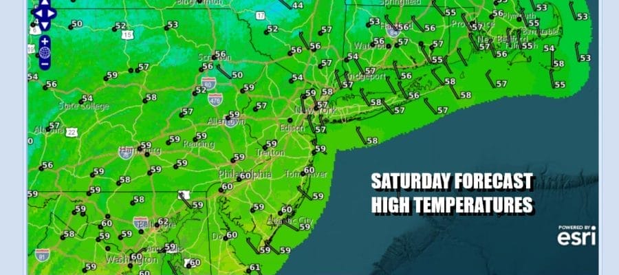
Energy from the Canada dives into the Ohio Valley and will eventually bring low pressure up the coast later next week but until then, the high to the north controls. Sunday looks to be mainly sunny but it is going to be rather cool. After a chilly start highs will only reach the middle to upper 50s at best.

Sunday night will be quite chilly with most lows at the coast in the lower 40s and inland lows will be in the low to mid 30s. Colder spots well inland will bottom in the 20s. Monday should be mainly sunny with highs in the low to mid 50s. Eventually the ocean flow will become more onshore and that likely will bring in clouds Tuesday and then the rain from the south heads northward for Wednesday into Thursday.
BE SURE TO DOWNLOAD THE FREE METEOROLOGIST JOE CIOFFI WEATHER APP &
ANGRY BEN’S FREE WEATHER APP “THE ANGRY WEATHERMAN!
MANY THANKS TO TROPICAL TIDBITS FOR THE USE OF MAPS
Please note that with regards to any severe weather, tropical storms, or hurricanes, should a storm be threatening, please consult your local National Weather Service office or your local government officials about what action you should be taking to protect life and property.


