
A Warming Trend On the Way
But Some Light Snow Possible Inland & North Late Today Into Tonight
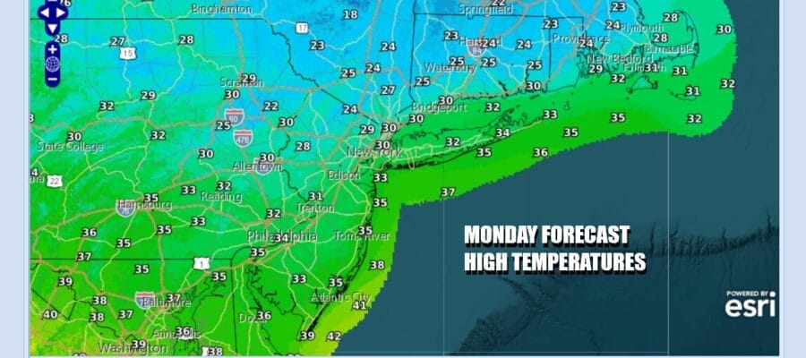
Some light snow is moving through parts of Eastern Pennsylvania, New Jersey, and the Hudson Valley thanks to a disturbance that is running ahead of warmer air moving eastward. Some whitening of the ground is possible as this disturbance goes by and there might even be the odd place or two that gets more than a dusting but not much more. In between all this we have lots of clouds and it will be cold today as temperatures hold mostly in the upper 20s and lower 30s. Much of this should pass through and it should be mostly done during the afternoon hours.
SATELLITE WITH LIGHTNING STRIKES

WEATHER RADAR

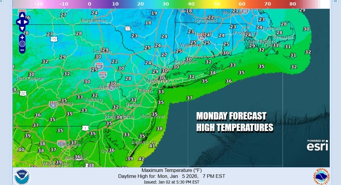
Models don’t seem to be handling this well as the radars are showing more than what models are. The transition to warmer air will continue Tuesday as another low and a warm front move east from the Great Lakes to New England. Most of the precipitation with this should pass to our north however the southern flank will pass close to Northern New Jersey to the Hudson Valley and Connecticut Tuesday night. There could be a little light rain or freezing rain in these areas as that warm front goes by. Some light glazing is possible in colder valleys where cold air will be trapped for a short time.

Ahead of this tonight we will have clouds around and that will hold temperatures up somewhat. Most lows Tuesday morning will be in the 20s to around 30. Tuesday will be a cloudy day until the warm front passes later Tuesday night or early Wednesday. There might be some breaks of sun in the mix Tuesday. Most highs will be in the upper 30s to lower 40s though in Southern New Jersey and points southward it could be a few degrees higher with slightly less cloud cover.
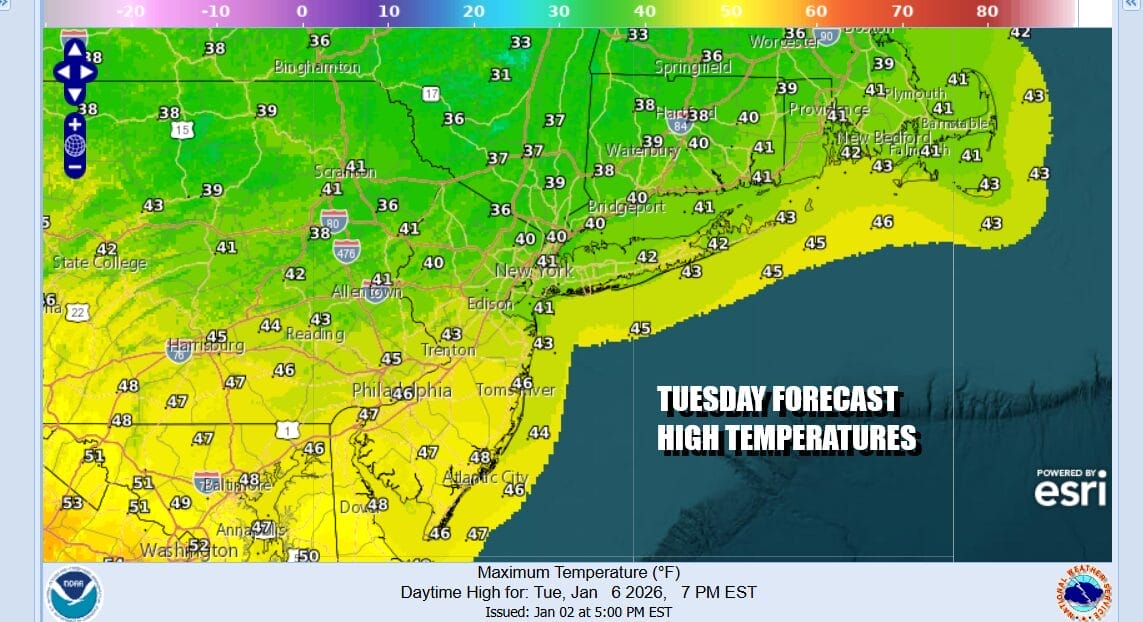
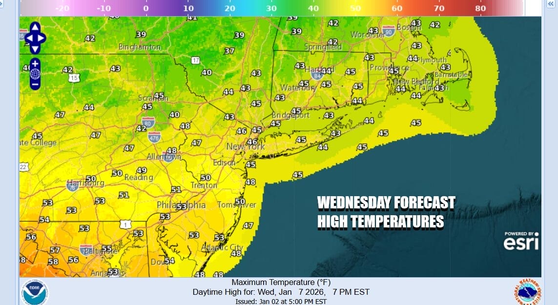
Tuesday night we could see some rain and again in colder valleys north and northwest of the coast some freezing rain is possible. Temperatures will likely hold steady overnight. Then Wednesday some sunshine should return and with a southwest wind. Highs will climb to the mid and upper 40s. Some lower 50s are possible across Southern New Jersey and Southern Pennsylvania southward.
We will continue to enjoy warmer than normal temperatures Thursday and Friday. Thursday looks to be a day of sunshine and it will feel quite nice. Highs will reach the upper 40s and lower 50s in many locations. Friday will see some rain early in the day as another warm front approaches ahead of a cold front. Showers will end during Friday morning but more rain is likely Friday night and Saturday as a slow moving cold front arrives. This front marks the leading edge of colder air and a colder weather pattern beginning Sunday and then continuing next week so the thaw from the winter cold is going to be relatively short lived.
BE SURE TO DOWNLOAD THE FREE METEOROLOGIST JOE CIOFFI WEATHER APP &
ANGRY BEN’S FREE WEATHER APP “THE ANGRY WEATHERMAN!
MANY THANKS TO TROPICAL TIDBITS FOR THE USE OF MAPS
Please note that with regards to any severe weather, tropical storms, or hurricanes, should a storm be threatening, please consult your local National Weather Service office or your local government officials about what action you should be taking to protect life and property.


