
A Sunny Sunday Much of the Week Ahead Will Be Dry
With Near Average Temperatures

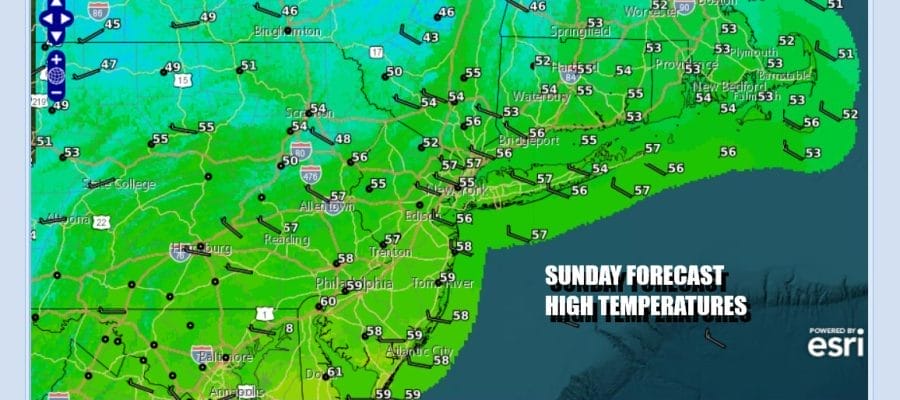
We have a nice day ahead to finish off the weekend. A chilly start but sunshine today will take temperatures to the mid and upper 50s this afternoon. The pressure gradient has relaxed so the wind is not going to be much of an issue today. There is some high level moisture ahead of weak low pressure moving across the deep south but other than some high clouds that will come into the mix we do not see any weather issues. Radars are nice and quiet for today. Look for some patchy clouds around tonight but some places will see at least partially clear skies. Cold spots inland will be in the 30s while most places near the coast and urban areas will bottom in the low to mid 40s Monday morning.
SATELLITE WITH LIGHTNING STRIKES

WEATHER RADAR

Two weather systems will be approaching Monday. One is coming southeastward across the Great Lakes. The other is low pressure off the Mid Atlantic coast. Between the two we will have some clouds around. The coastal low could graze the coast with a bit of light rain while the the system to the north could produce some scattered showers as a cold front goes by later in the day Monday.

The two systems will phase together to the east so this should not be a big deal for Monday. Expect clouds for much of the day. We will throw in the chance for some rain near the coast and the chance for showers being enhanced a bit Monday afternoon. Most highs Monday will be in the 50s. Some warm spots in Southern New Jersey could approach 60 degrees.

Tuesday looks to be a dry day of sunshine and highs in the 50s. Another weather front approaches Wednesday and with this we could see a shower or two late in the day Wednesday or Wednesday night but it will not amount to much. Highs Wednesday will be in the lower 60s in most places. A shot of colder air comes behind the front but it comes in quick and it is limited. Thursday we will see sunshine return with highs in the low to mid 50s. Friday looks to be dry ahead of another weak weather front that will pass Friday night into early Saturday. No major storms are on the horizon for the week ahead.
BE SURE TO DOWNLOAD THE FREE METEOROLOGIST JOE CIOFFI WEATHER APP &
ANGRY BEN’S FREE WEATHER APP “THE ANGRY WEATHERMAN!
MANY THANKS TO TROPICAL TIDBITS FOR THE USE OF MAPS
Please note that with regards to any severe weather, tropical storms, or hurricanes, should a storm be threatening, please consult your local National Weather Service office or your local government officials about what action you should be taking to protect life and property.


