

USE THE COUPON CODE “SPRING2026” AND GET 10 PERCENT OFF ON ANY PURCHASE

Gloom & Doom Continues Rain Ends Later Today Showers Come Back Tonight into Monday
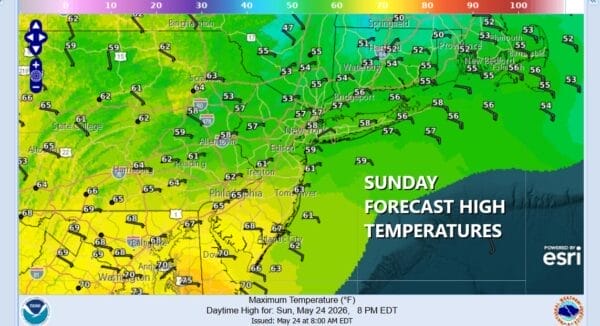
it is the kind of Sunday where it is easier to sleep in thanks to lots of clouds, an onshore flow off the cold ocean, and of course rain. Overnight into this morning some areas in Eastern Pennsylvania to Southern New England and Long Island have gotten into areas of moderate to heavy rain. All of this will continue into this afternoon, slowly shifting eastward so that eventually much of the area catches a short break from the rain. Temperatures today in this miserable mess will be hard pressed to get out of the 50s in most areas.
SATELLITE WITH LIGHTNING STRIKES

WEATHER RADAR

Even though low pressure along a stalled frontal boundary to the south moves east, we have another upper trough to the west in the Great Lakes that is producing showers and thunderstorms there. That trough will move east and bring another round of showers overnight into Monday. There might even be a thunderstorm or two in the mix. This areas seems more patchy rather than widespread in nature but some of you are going to see more rain before this is all said and done.
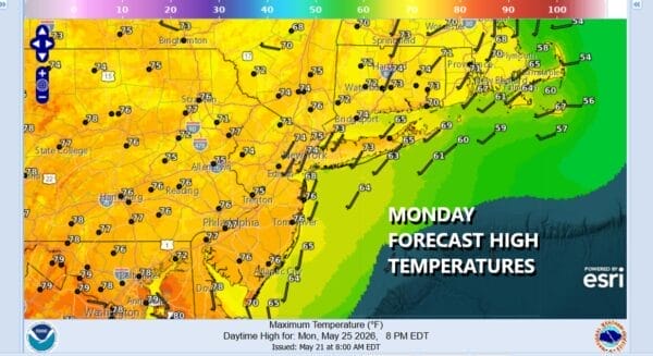
Winds going from east to southwest will help the cause temperature wise Monday so highs will likely get back into the 70s. If everything goes according to plan we will see morning showers giving way to some improving weather conditions Monday afternoon. Tuesday we see more improving with some sunshine, more as you head north and less as you go south where a frontal boundary will remain across the Mid Atlantic states. Highs Tuesday will be in the upper 70s and lower 80s. Dry warm conditions will continue Wednesday. A cold front will pass late Wednesday with a shower or two possible followed by cooler conditions for Thursday and Friday, though it will be dry and mainly sunny both days.


