
USE THE COUPON CODE “SPRING2026” AND GET 10 PERCENT OFF ON ANY PURCHASE

Last Day of 90 Degree Plus Heat
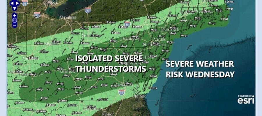
Thunderstorms Severe Weather Risk
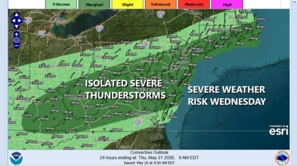
Today is the last day of the extreme heat. Yesterday we saw record breaking highs in the mid to upper 90s in many locations. Today we will see the heatwave end thanks to an approaching cold front that will set off showers, thunderstorms, and severe weather risk. The Storm Prediction Center is indicating the risk for isolated severe thunderstorms to be in the mix from extreme Southeastern New England south and west across Long Island, New York City, New Jersey, Pennsylvania back to West Virginia and Kentucky.
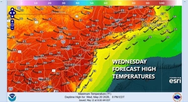
The front is set to arrive early to mid afternoon so this knocks a couple of hours off the daytime heating factor. Highs today will be less extreme but still up there into the upper 80s and lower 90s before showers and thunderstorms arrive with the cold front. This weather front is going to take it’s time moving through and while there will be an initial shot of storms that last into this evening, they will wind down tonight for a short time. During the early morning hours with the front temporarily stalled, some showers and downpours will develop going into Thursday morning, mainly from Southern Connecticut to New York City and New Jersey southward.
SATELLITE WITH LIGHTNING STRIKES

WEATHER RADAR

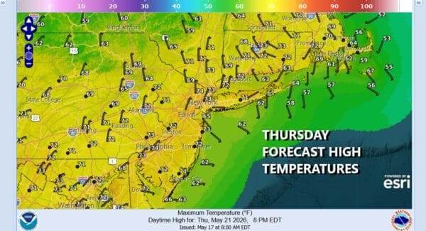
Thursday will see those showers taper off and sink southward around midday or early Thursday afternoon so there could be some improvement developing. Otherwise you can expect a lot of clouds around. Temperatures Thursday will probably be holding in the upper 60s and lower 70s which is a lot closer to where we should be this time of year.
The improvement will be short lived as the front drops south to Virginia, stalls, and then comes back northward as a warm front. Friday look for any sunshine to give way to arriving clouds with highs generally in the 60s thanks to a developing onshore flow. Rain will develop later Friday night into Saturday morning. Saturday looks like a gloom and doom type day with rain, an ocean wind, and temperatures just into the 60s. Rain is going to last into early Sunday but we could dry out Sunday afternoon. Highs Sunday will be in the upper 60s and lower 70s. Monday look for clouds, some sun, and the risk for afternoon showers. Memorial Day highs will be into the 70s.
DOWNLOAD THE UPSIDE APP & EARN CASH AT GAS STATIONS, RESTAURANTS, & SUPERMARKETS

BE SURE TO DOWNLOAD THE FREE METEOROLOGIST JOE CIOFFI WEATHER APP &
ANGRY BEN’S FREE WEATHER APP “THE ANGRY WEATHERMAN!
MANY THANKS TO TROPICAL TIDBITS FOR THE USE OF MAPS
Please note that with regards to any severe weather, tropical storms, or hurricanes, should a storm be threatening, please consult your local National Weather Service office or your local government officials about what action you should be taking to protect life and property.


