
USE THE COUPON CODE “SPRING2026” AND GET 10 PERCENT OFF ON ANY PURCHASE

Hot Weather Coming Ahead of Midweek Cold Front
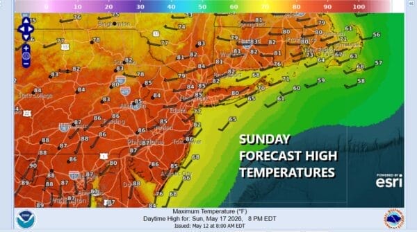
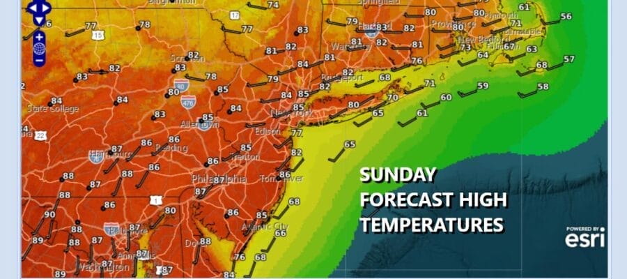
Today begins a big warm up as we have a ridge of high pressure off the Southeast US coast and a strong ridge building aloft for a day or two in the Eastern US. Satellite loops show some patchy blow clouds from dying showers in the Central Appalachians. Overall today we are looking at partly to mostly sunny skies across Eastern Pennsylvania to Southern New England. Temperatures today will reach the mid to upper 80s and with a west to southwest winds, sea breezes along the coast will generally be localized with not much penetration inland. Some hot spots inland could reach 90 degrees or so. Radars are nice and quiet today.
SATELLITE WITH LIGHTNING STRIKES

WEATHER RADAR

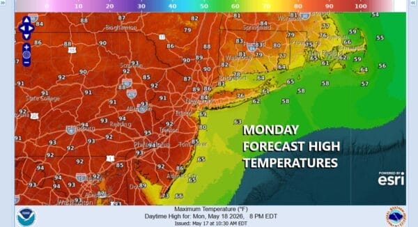
Most lows tonight will be in the 60s with nothing more than some passing clouds. Monday we will see a bit more of south wind so that will impact temperatures near the coast. Most highs will be in the upper 70s and lower 80s from New York City east and north and east. However go just inland in New Jersey and Eastern Pennsylvania and highs will reach the low 90s and some reading well inland could reach 94 or 95. Skies will be partly to mostly sunny.
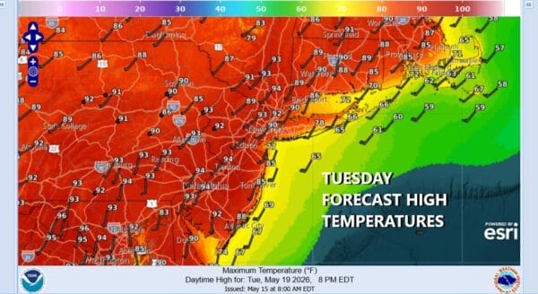
On to Tuesday where the wind will be more south southwest rather than south southeast so that means everyone except the immediate coastal areas will reach highs in the low to middle 90s with plenty of sunshine. We are going to throw in the chance for a shower or thunderstorm popping up inland.
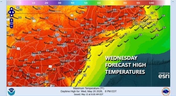
Wednesday will be the last very hot day of this particular stretch. After morning lows that will barely get back to 70 in warmer urban locations and 60s everywhere else, sunshine will take highs again into the low and middle 90s. However there is a cold front coming with shower and thunderstorms later in the afternoon and evening and that will put an end of the 90 degree plus highs for awhile.
Thursday and Friday will be 20 degrees cooler as a new dome of high pressure builds in from the Great Lakes. Most highs will be in the low 70s Thursday and mostly in the 60s to near 70 Friday. Both days will be dry with no worse than partly sunny skies. As far as the Memorial Day holiday weekend goes, this is the one weekend of the so called summer weekends where you are likely to lose at least 1 day to rain and possibly 2. This year it looks like we are going to see some rain for later Saturday into at least part of Sunday with a dry Monday with temperatures on the coolish side of normal depending on cloud cover and rainfall.
DOWNLOAD THE UPSIDE APP & EARN CASH AT GAS STATIONS, RESTAURANTS, & SUPERMARKETS

BE SURE TO DOWNLOAD THE FREE METEOROLOGIST JOE CIOFFI WEATHER APP &
ANGRY BEN’S FREE WEATHER APP “THE ANGRY WEATHERMAN!
MANY THANKS TO TROPICAL TIDBITS FOR THE USE OF MAPS
Please note that with regards to any severe weather, tropical storms, or hurricanes, should a storm be threatening, please consult your local National Weather Service office or your local government officials about what action you should be taking to protect life and property.


