
Relatively Quiet Weather Pattern Warm Saturday Colder
Chance For A Little Snow Sunday

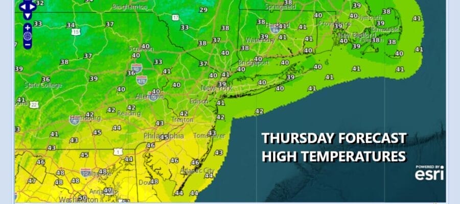
We continue to calm down weather wise after the big snowstorm and a cold front has passed through this morning, sinking southward and stalling across the Mid Atlantic states. Rain covers a large portion of the Tennessee Valley and Southeast US to about Virginia. A wave on that front will pass to the south later today and tonight. We will have clouds from this but rain should stay way, except for perhaps southernmost New Jersey where rain could nudge in for a few hours late today into tonight. Otherwise we will have clouds with some breaks of sun today with highs mostly in a range of 40 to 45 degrees so at least the temperatures are warm enough for snowmelt to continue.
SATELLITE WITH LIGHTNING STRIKES

WEATHER RADAR

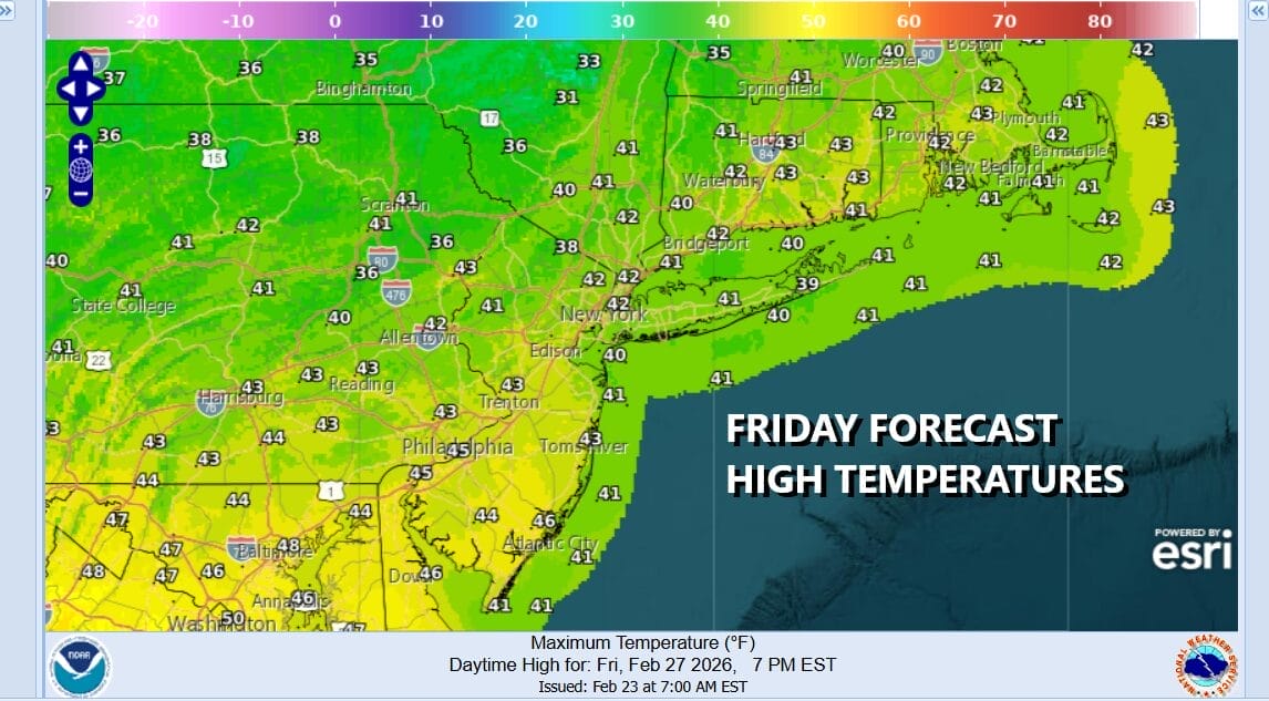
Once this wave goes by we are left with drier air coming in on the back side of the southern wave which will continue to move eastward and offshore. Skies should clear up tonight. Most lows will be in the upper teens to mid 20s by morning. Friday is looking to be a good day with sunshine. Highs will reach the low and middle 40s in most places.
Another cold front will be approaching with a shot of colder air but Saturday will be a nice day ahead of it. It will also be the warmest day we have seen in quite a while. Look for sunshine and temperatures that will reach the 50s in many locations. The exception will be south and east facing shoreline where the wind off the cold ocean will keep temperatures about 10 or so degrees lower during the afternoon and evening hours.

A cold front passes later Saturday night without much fanfare however during Sunday a little wave on the front develops as colder air arrives so there is the chance we could see a little snow Sunday. This is a minor system and is not expected to develop much. We are not expecting any surprises from this wave as it goes by to our south but it will pull down colder air for the start of next week.

The high will extend from the Great Lakes and New England and we have seen models show an area of overrunning snow developing in parts of the Ohio and Tennessee Valley However the cold high likely suppresses this system to the south. This seems to be the way this has headed and as long as we don’t see models return to more robust solutions, we feel confident that we may have see the last of any serious snow threats. We will wait to see how models handle this later today. After Tuesday as our weather pattern changes across North America, cold air flow from Canada is shut off and a Pacific flow of air takes over for later next week and probably beyond that which I believe will be welcomed by everyone but avid snow lovers which never seem to get enough where snow is concerned. Sunday temperatures will settle in the 30s with the chance for some snow mid morning to mid afternoon. Monday will be very cold with some sun and clouds, assuming we don’t have any weather system to our south to deal with. Highs will be only in the upper 20s and lower 30s. Tuesday will remain cold but the second half of next week, temperatures will move higher.
BE SURE TO DOWNLOAD THE FREE METEOROLOGIST JOE CIOFFI WEATHER APP &
ANGRY BEN’S FREE WEATHER APP “THE ANGRY WEATHERMAN!
MANY THANKS TO TROPICAL TIDBITS FOR THE USE OF MAPS
Please note that with regards to any severe weather, tropical storms, or hurricanes, should a storm be threatening, please consult your local National Weather Service office or your local government officials about what action you should be taking to protect life and property.


