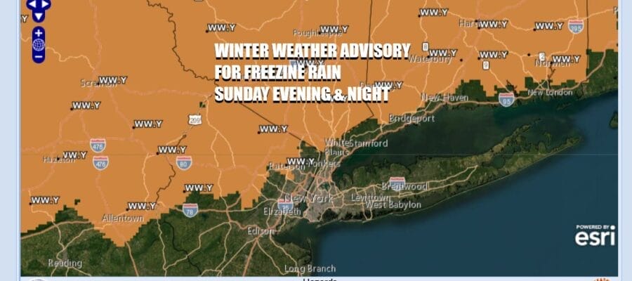

Winter Weather Advisories for Freezing Rain Tonight In Areas Inland
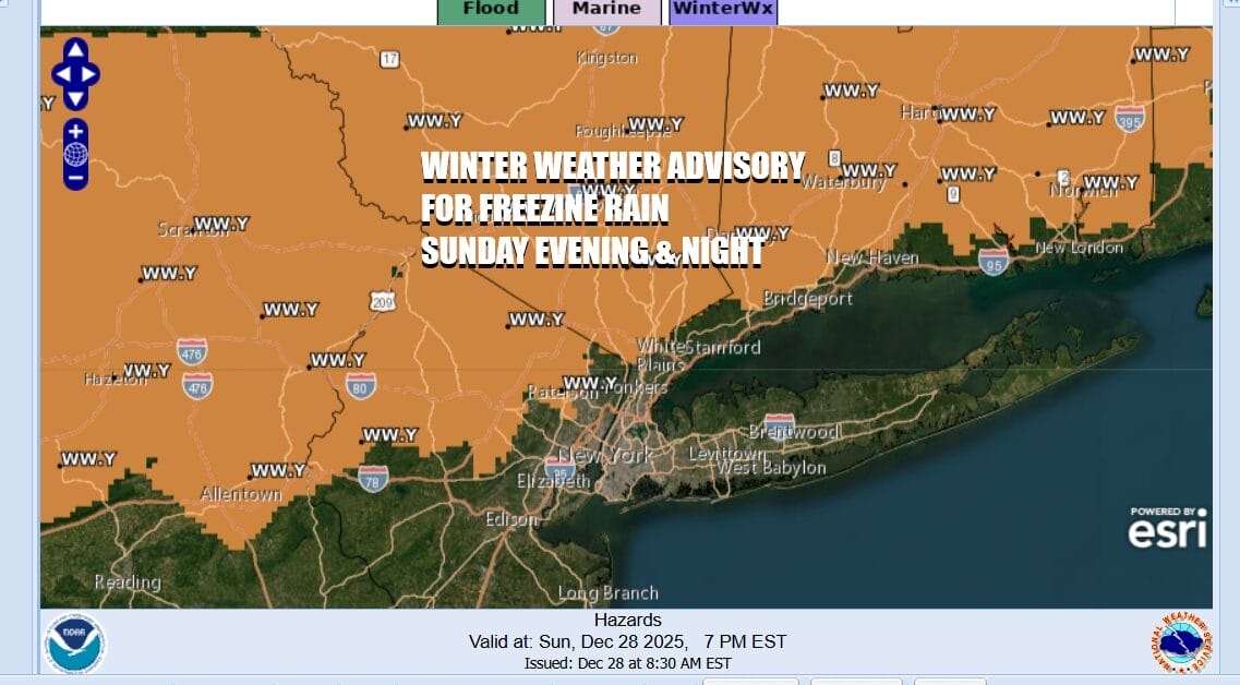
The next round of fast moving changes gets underway today as a powerful storm over the Great Lakes heads eastward. A warm front is setting up to the south. Clouds will be increasing today with highs back into the 30s. Late today precipitation from a warm front will be moving in and areas inland will see temperatures near or below freezing for most if not all of today. Winter Weather Advisories are posted for late this evening into the first part of tonight for much of Northern New Jersey mainly west and northwest of Interstate 287, the Hudson Valley north of Interstate 287 and in Connecticut north of Interstate 95.
SATELLITE WITH LIGHTNING STRIKES

WEATHER RADAR

Clouds are beginning to roll in from the west and we can see the beginnings of precipitation in Pennsylvania moving eastward. In the meantime much if not all of the dayside in Eastern Pennsylvania to Southern New England will be dry into the afternoon and the the rain moves in to areas where temperatures below 32. Most high temperatures today will be reached around midnight as temperatures overnight hold steady or slowly rise. This is not going to be an issue for coastal and urban areas.

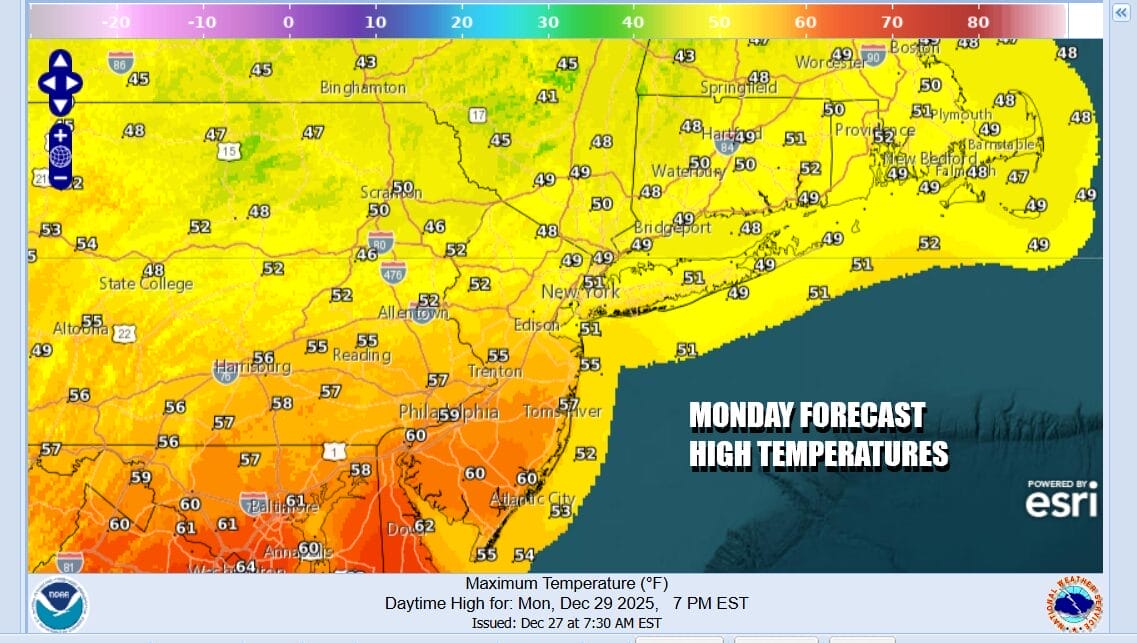
Freezing rain will change over to rain from south to north overnight. Cold air trapped in valleys will delay the change over to plain rain but eventually those areas will change to rain as well. Most of the rain from the warm front is probably done by midnight or 1am and then the cold front arrives Monday morning with some showers. Once the front passes northwest winds will takeover and increase. Highs Monday could reachin into the 50s in many locations but that should happen early in the day and then temperatures will ease some later in the afternoon Monday with clouds and some sunshine developing.
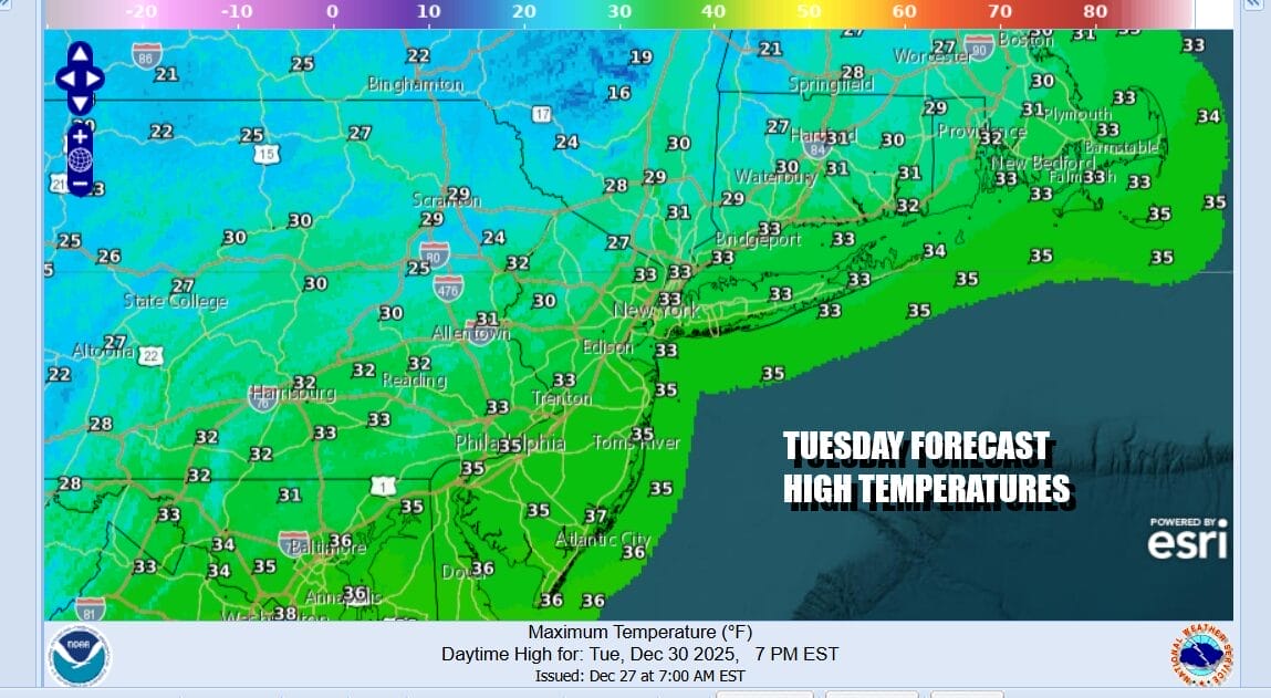
Windy and colder conditions return Monday night as skies clear. Most lows Tuesday morning will be in the 20s. The wind machine will be on Tuesday with winds gusting 30 to perhaps 40 mph at times along with at least some sunshine. High temperatures Tuesday will only make it back into the 30s and the down into the 20s Tuesday night into Wednesday morning.
Another cold front which will mark the leading edge of a re-enforcing surge of colder air will arrive later Wednesday or Wednesday night. There won’t be much with the front itself so skies should be no worse than partly sunny for New Years Eve with highs in the 30s. There may be some clouds around Wednesday night into New Years Day and we will watch to see if a wave tries to develop on the front. Should that be the case we could see some snow showers or a brief period of snow New Year’s Day.
BE SURE TO DOWNLOAD THE FREE METEOROLOGIST JOE CIOFFI WEATHER APP &
ANGRY BEN’S FREE WEATHER APP “THE ANGRY WEATHERMAN!
MANY THANKS TO TROPICAL TIDBITS FOR THE USE OF MAPS
Please note that with regards to any severe weather, tropical storms, or hurricanes, should a storm be threatening, please consult your local National Weather Service office or your local government officials about what action you should be taking to protect life and property.


