
Another Cold Front Passes With Cold Air Behind It Even Colder Next Weekend
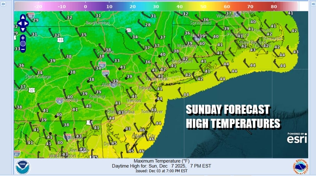
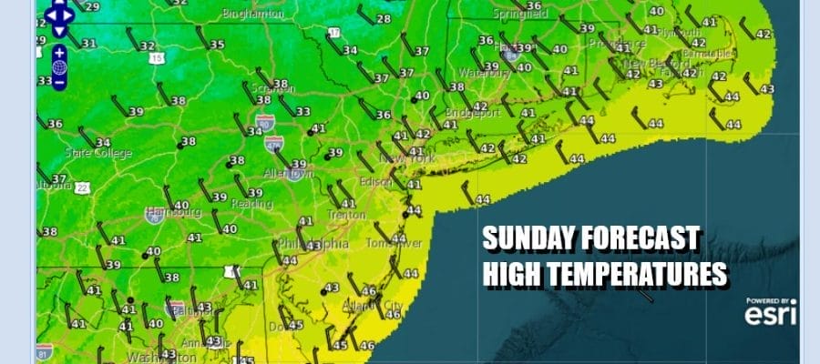
We continue to be in this rather fast west to northwest flow which is bringing weather systems through from time to time. These systems are cold fronts that don’t have much in the way of moisture. One such front approaches this afternoon and evening with clouds increasing ahead of it. Radars are showing some areas of light snow moving across well to the north in Upstate New York and Southeastern Canada. We do not expect any precipitation as the front passes. Most highs this afternoon will be in the upper 30s and lower 40s.
SATELLITE WITH LIGHTNING STRIKES

WEATHER RADAR

The front passes through tonight and another cold air mass builds in for the start of the work week. The front will also suppress a wave of low pressure coming out of the Gulf of Mexico and moving off the Southeast US coast Monday. Some snow will reach northward into Virginia and Northern North Carolina however we expect to see this system exit to the east with no consequence to our weather whatsoever.

Monday and Tuesday should be no worse than partly sunny on both days. Temperatures are going to continue to run below average over Eastern Pennsylvania to Southern New England. Another weather system will pass to the north Tuesday with no weather issues here but there might be more clouds Tuesday verses Monday. Highs Monday will be in the low to mid 30s. Tuesday highs will be in the middle to upper30s.

Wednesday brings yet another cold front. This one might have a little more moisture to it and there might be a few showers Wednesday afternoon and evening, followed by another shot of cold air for Thursday and Friday. Wednesday highs will be warming to the mid to upper 40s. Thursday and Friday will be colder with highs in the upper 30s and lower 40s Thursday and in the 30s Friday. These air masses are colder than normal but not harsh. Another cold front will arrive Saturday and as along as there are no complications from a developing wave, we will simply turn sharply colder later next weekend.
BE SURE TO DOWNLOAD THE FREE METEOROLOGIST JOE CIOFFI WEATHER APP \&
ANGRY BEN’S FREE WEATHER APP “THE ANGRY WEATHERMAN!
MANY THANKS TO TROPICAL TIDBITS FOR THE USE OF MAPS
Please note that with regards to any severe weather, tropical storms, or hurricanes, should a storm be threatening, please consult your local National Weather Service office or your local government officials about what action you should be taking to protect life and property.


