
Windy Conditions Continue Though Winds Off Their Peaks,
Cold Weather Into Thursday
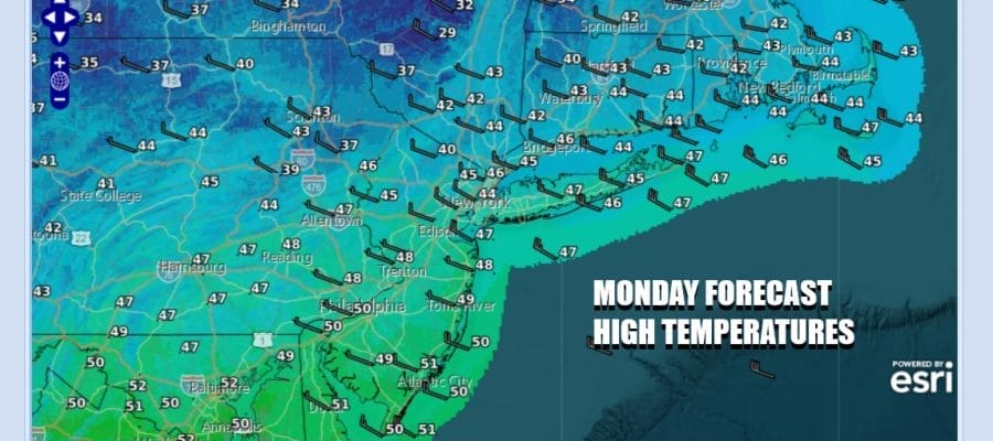
Winds are lower from their peaks of yesterday however we are still going to be windy at times today. The northwest flow is obvious on satellite and radar loops this morning. Lake effect snow is streaming across parts of New York State and Pennsylvania. Many areas will see a mix of sun and clouds today. The stray snow shower can’t be ruled out especially inland. It is going to be a cold day with high temperatures just in the 40s in most places. The wind will make it feel 5 to 10 degrees colder.
SATELLITE WITH LIGHTNING STRIKES

WEATHER RADAR

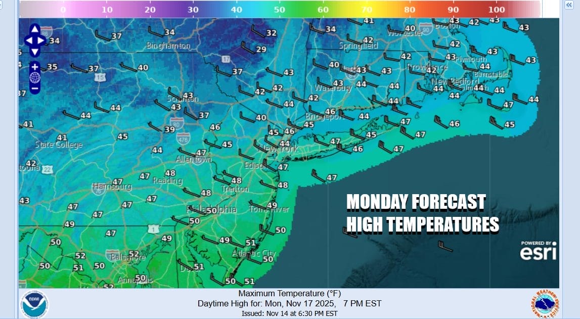
Tonight skies should at least partially clear if not going mostly clear entirely. It will still be breezy which will create mixing. Low temperatures will be in a tight range from upper 20s inland and low to mid 30s coast and warm urban locations. Tuesday the wind will be much lower. We will start off with sunshine but some high clouds will be increasing. High temperatures Tuesday again will be mostly in the 40s.
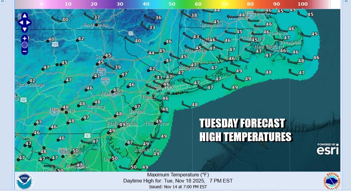
Much of this week will be dry. However we do have energy coming into the Pacific that will be ejected eastward. Low pressure from Missouri will be heading eastward Tuesday into Wednesday. The system is weak and will likely get weaker as it heads east but there will be an area of rain with this low. We could see a little light rain Tuesday night into Wednesday morning though models keep the rain mostly south of New York City.

We will throw in the chance for a little light rain Tuesday night into Wednesday. If it does rain it won’t amount to much; certainly under a quarter of an inch and likely under a tenth of an inch. It should be mostly done by Wednesday morning and then we will see some improvement with decreasing clouds. Highs Wednesday will again be only in the 40s as clouds at least for awhile will hold temperatures down.
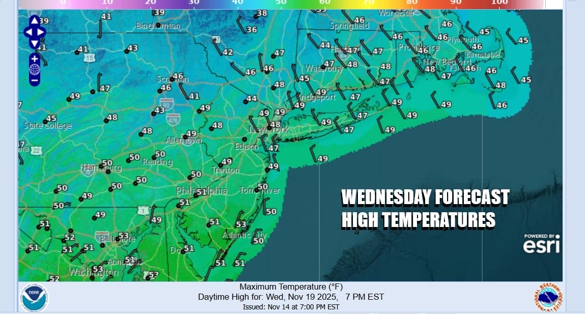
Temperatures might nudge up a bit come Thursday with highs in the upper 40s and lower 50s. We will stay dry through Friday. Friday night into Saturday morning another low will come out of the Plains and it might behave the same way as the Tuesday/Wednesday system, weakening as it heads eastward. We might see some light rain Friday night into Saturday morning followed by improving weather conditions as we move through the weekend.
BE SURE TO DOWNLOAD THE FREE METEOROLOGIST JOE CIOFFI WEATHER APP &
ANGRY BEN’S FREE WEATHER APP “THE ANGRY WEATHERMAN!
MANY THANKS TO TROPICAL TIDBITS FOR THE USE OF MAPS
Please note that with regards to any severe weather, tropical storms, or hurricanes, should a storm be threatening, please consult your local National Weather Service office or your local government officials about what action you should be taking to protect life and property.


