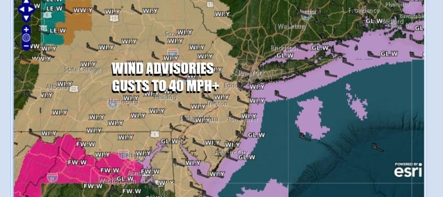

Wind Advisories Gusts Over 40 MPH Possible Into Monday

The Northeast wind machine is turned on again as low pressure in Eastern New England moves slowly into Atlantic Canada and intensifies. In the meantime high pressure is to the west and the pressure gradient is tightening up once again. Wind Advisories are posted for winds gusting past 40 mph this afternoon into Monday. This system is also bringing down colder air on these gusty northwest winds as well as producing lake effect heavy snows in parts of Western New York and Western Pennsylvania.
SATELLITE WITH LIGHTNING STRIKES

WEATHER RADAR

Along much of the coastal plain from Southern New England southward and westward into Eastern Pennsylvania overnight showers are done and now we will see sky conditions improve but there will be some instability in the atmosphere. Expect a mix of sun and clouds for the remainder of the day. We do have some leftover milder air from overnight so highs will be in the 50s though we could see temperatures ease a bit later this afternoon and into this evening.

Gusty winds will continue overnight as skies partially clear out. Monday morning lows will be mostly in the 30s with a few 20s in the coldest spots inland. The gusty winds will keep temperatures relatively uniform from the coast to inland areas. Monday looks to be no worse than partly sunny. Winds will continue to be strong and gusty. Temperatures will be cold for this time of year with highs only in the 40s.

The week ahead looks to be mostly dry and chilly through at least the first half. There are a couple of what I would regard as nuisance systems in the flow. The first will be Tuesday night into Wednesday as low pressure heads from Kansas to Virginia and weakening along the way. There might be some clouds with that later Tuesday into early Wednesday along with a little light rain from Southern Pennsylvania to Southern New Jersey southward. Any rain will be light and f
Next on the system parade will be low pressure heading to the Great Lakes with a trailing cold front over next weekend but it is hard to say at this point what that produces if anything at all as far as precipitation is concerned. Meanwhile gusty winds will continue into Tuesday though they should relax some. We will have sunshine and some high clouds with highs in the 40s. Again there is that chance for a little rain from Southern New Jersey to Southern Pennsylvania southward. Wednesday should see clouds and some sun with highs in the 40s. There after temperatures may start to creep higher late week and going into the weekend.
BE SURE TO DOWNLOAD THE FREE METEOROLOGIST JOE CIOFFI WEATHER APP &
ANGRY BEN’S FREE WEATHER APP “THE ANGRY WEATHERMAN!
MANY THANKS TO TROPICAL TIDBITS FOR THE USE OF MAPS
Please note that with regards to any severe weather, tropical storms, or hurricanes, should a storm be threatening, please consult your local National Weather Service office or your local government officials about what action you should be taking to protect life and property.


