
Some Rain Tonight Into Sunday Morning But Dry On Either Side,
Dry Sunny Week Ahead

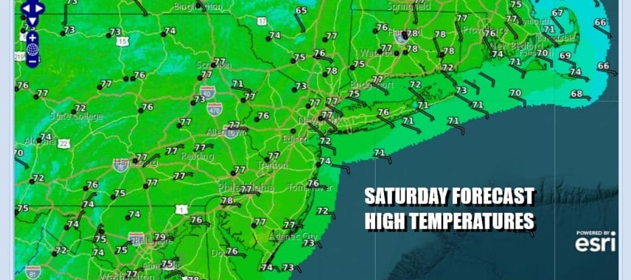
if it is going to rain on a weekend, I always say it is best to have it rain at night. That is where we are at today as we expect to see a good looking Saturday at least to start. Clouds are beginning to increase from south to north but rain should likely stay away until the evening. Temperatures today will be mostly in the low to mid 70s with the cooler end of the range at the coast. Onshore winds continue and that helps to hold temperatures down.
SATELLITE WITH LIGHTNING STRIKES

WEATHER RADAR

A wave of low pressure is bringing an area of moisture up the coast and you can see the rain to the south on the regional radar. That rain will come through tonight into early Sunday morning. It should be mostly gone by daybreak and then we will see general improvement in weather conditions as we move through the day Sunday.

High pressure will begin building into Southeastern Canada and the Northeast and next week and that will keep the weather dry all week long. It will also help to deflect major hurricane Humberto to the east midweek, forcing it to turn north and then eastward. Also we will likely have Tropical Storm or Hurricane Imelda near the Southeast US coast but overnight models are now showing it getting close to the close, stalling briefly and then turning to the east as well. This is a shift from the inland more westward track of the last few days. We will see where this takes us on weather models going forward.

Sunday see highs in the low to mid 70s with clouds and some developing pm sun. Monday looks like a nice day of no worse than partly sunny skies with highs in the 70s. The same holds for Tuesday but Wednesday and Thursday will be cooler with a gusty northeast wind thanks to that large high building into New England and Atlantic Canada. Highs Wednesday and Thursday will likely be mostly in the 60s.
BE SURE TO DOWNLOAD THE FREE METEOROLOGIST JOE CIOFFI WEATHER APP &
ANGRY BEN’S FREE WEATHER APP “THE ANGRY WEATHERMAN!
MANY THANKS TO TROPICAL TIDBITS FOR THE USE OF MAPS
Please note that with regards to any severe weather, tropical storms, or hurricanes, should a storm be threatening, please consult your local National Weather Service office or your local government officials about what action you should be taking to protect life and property.


