USE THE COUPON CODE “SPRING2026” AND GET 10 PERCENT OFF ON ANY PURCHASE
Week Ahead Heatwave Develops Tuesday Through Thursday
With No Storms Forecast
An east west frontal boundary lies across the Mid Atlantic states and clouds on satellite loops as well as showers and thunderstorms on the radars are generally moving west to east. This leaves Eastern Pennsylvania to Southern New England, including New Jersey, the Hudson Valley and Long Island in a good spot. Skies are clear across the Northeast and we will see plenty of sunshine today, reasonable humidity levels and highs in the low to middle 80s. No rain is forecast today and we may not see a drop of rain or hear a rumble of thunder all week long.
SATELLITE WITH LIGHTNING STRIKES
WEATHER RADAR
A heat ridge is building in the United States but this time around, the ridge is building from the Northern Rockies and Plains east to the Western Great Lakes. We here in the Northeast and Northern Mid Atlantic states will be on the edge of the heat ridge. It means winds aloft will be from the northwest. We don’t have any disturbances riding up from the the Western Gulf States and coming over the top of the upper high.
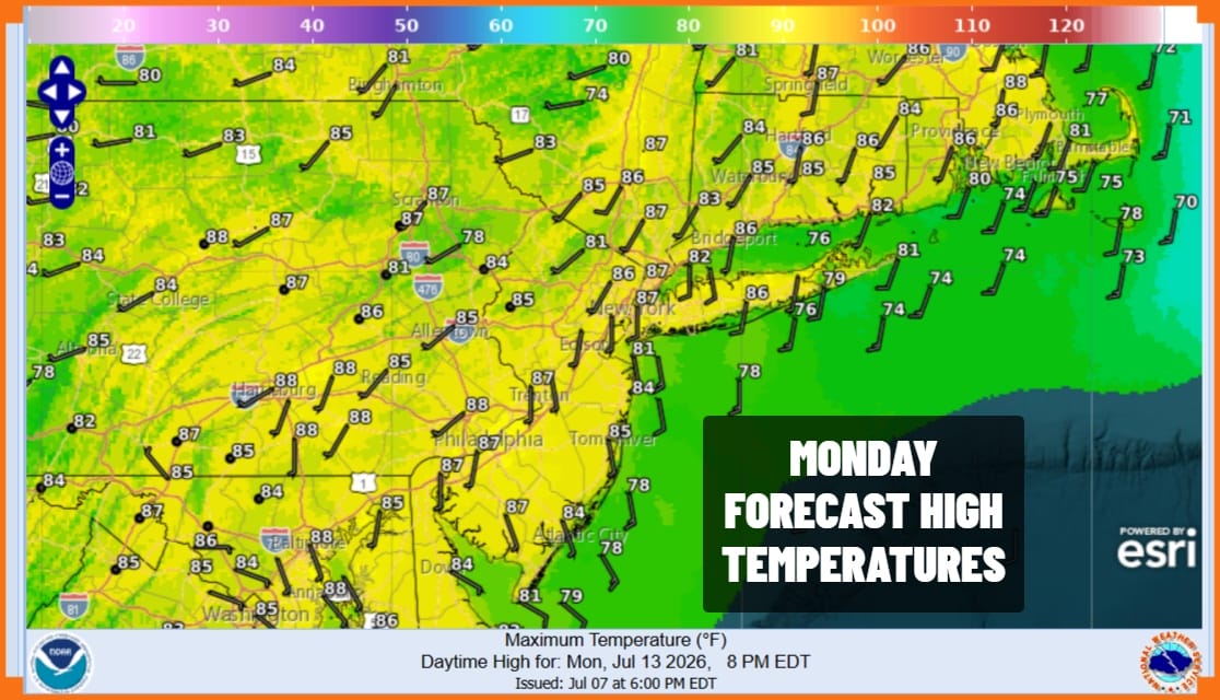
We will still hold on to reasonable humidity levels Monday though we also expect to see temperatures move a little higher. Most highs Monday will be in the mid to upper 80s with cooler highs at area beaches. We will see plenty of sunshine. Tuesday we see humidity levels rise somewhat and temperatures rise as well with plenty of sunshine. Tuesday will the first of 3 days with 90 degree plus highs. Highs are forecast to reach the lower 90s, again a little cooler at the beaches.
Wednesday will be the hottest day of the week. This is the day of peak ridge strength before the ridge deflates and a cold front passes through Wednesday night. Sunshine Wednesday will take highs to the middle and upper 90s. Even though we do have a weather front passing, little to no shower or thunderstorm activity is forecast due to the stable nature of the atmosphere.
Thursday will be the third and final day of the streak of 90 degree plus highs however we will see humidity levels drop on northerly winds. Highs Thursday will reach the lower 90s with sunshine. We will finish off the week with lower humidity conditions and some sunshine for Friday with highs back to the 80s.
DOWNLOAD THE UPSIDE APP & EARN CASH AT GAS STATIONS, RESTAURANTS, & SUPERMARKETS
BE SURE TO DOWNLOAD THE FREE METEOROLOGIST JOE CIOFFI WEATHER APP &
ANGRY BEN’S FREE WEATHER APP “THE ANGRY WEATHERMAN!
MANY THANKS TO TROPICAL TIDBITS FOR THE USE OF MAPS
Please note that with regards to any severe weather, tropical storms, or hurricanes, should a storm be threatening, please consult your local National Weather Service office or your local government officials about what action you should be taking to protect life and property.