USE THE COUPON CODE “SPRING2026” AND GET 10 PERCENT OFF ON ANY PURCHASE
Sunshine Delightful Monday Ahead of Severe Storms
Tornado & Flash Flood Risks Tuesday
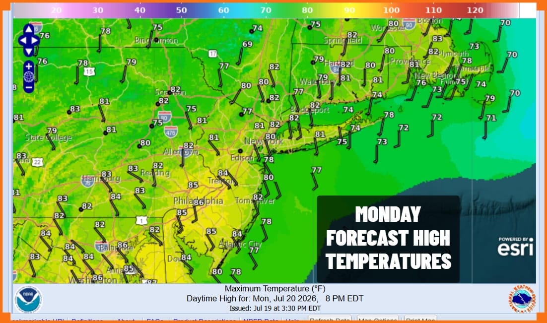
The day starts off with delightfully dry weather conditions and lows in the mid 50s to lower 60s. This was truly a treat for July which is of course the hottest month of the year. To have days like this is truly a gift from the weather gods. Sunshine today will be ample. Humidity levels will be very subdued. High temperatures will reach into the lower 80s which is actually a little lower than where we should be for this time of year. No rain, no showers, no thunderstorms, no nothing is forecast for today!
SATELLITE WITH LIGHTNING STRIKES
WEATHER RADAR
Weather conditions are set to deteriorate as humidity levels climb. A warm front is moving northward and a cold front will swinging out of the Midwest and head for the Northeast and Mid Atlantic states. The set up is very similar to what happened Saturday and a similar outcome of showers, thunderstorms, severe weather and local flash flooding is in the forecast for the daytime Tuesday into Tuesday night.
The Storm Prediction Center started out with a slight risk for severe storms and has expanded that area north and east into Western New England. However they have not only added an area of an enhanced risk but they pushed that area further east in overnight forecasts. In addition we have tornado risk of 2 to 5 percent over a large area across Eastern Pennsylvania to Southern New England.
I suspect we could see additional expansions and changes in the outlook forecast as Tuesday nears. Some downpours will develop in the morning Tuesday but the main game will be later in the afternoon into Tuesday night. 3/4 inch to 1.25 inches of rain seams to be doable area wide but when dealing with these summer convection situations, local amounts could easily be double the forecast and local flash flooding risk is certainly on the table. Temperatures Tuesday will reach the upper 70s and lower 80s.
The front will move offshore during the early morning hours Wednesday bringing a break to showers however the upper trough won’t pass until later in the day so we could see changeable skies and another round of showers or a rumble or two of thunder early to mid afternoon before weather conditions improve considerably Wednesday night. Thursday and Friday look like 2 days of sunshine, lower humidity, and reasonable temperatures for this time of year.
DOWNLOAD THE UPSIDE APP & EARN CASH AT GAS STATIONS, RESTAURANTS, & SUPERMARKETS
BE SURE TO DOWNLOAD THE FREE METEOROLOGIST JOE CIOFFI WEATHER APP &
ANGRY BEN’S FREE WEATHER APP “THE ANGRY WEATHERMAN!
MANY THANKS TO TROPICAL TIDBITS FOR THE USE OF MAPS
Please note that with regards to any severe weather, tropical storms, or hurricanes, should a storm be threatening, please consult your local National Weather Service office or your local government officials about what action you should be taking to protect life and property.