USE THE COUPON CODE “summer2026” AND GET 10 PERCENT OFF ON ANY PURCHASE
Rain Rain Go Away Monday Is Columbus Day!
No doubt about it folks, it is a gloom and doom type Sunday with miserable gray skies and rain. Satellite and radar loops show rain overspreading the Northeast and Mid Atlantic states. These are some of the remnants of Hurricane Isaias as well as a developing storm system in North Carolina that will be heading northeast to off the coast of New Jersey and Long Island Monday morning. The result is rain! Also we have temperatures the will basically be hovering in the low and mid 60s all day. Some spots will stay in the 50s.
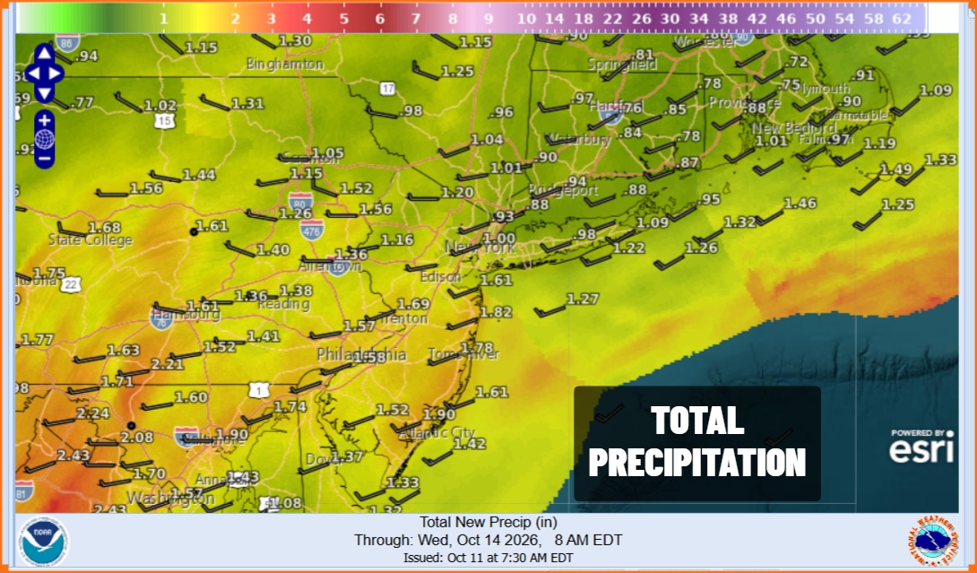
As far as rainfall totals go, we are looking at about an inch to an inch and half total with some locally higher amounts. Since this is spread out over the next 18 hours or so and not concentrated in an hour or two means that the risk for some localized flash flooding is low. Only the most vulnerable of spots where there is poor drainage might see some ponding. Otherwise this is miserable but mana
SATELLITE WITH LIGHTNING STRIKES
WEATHER RADAR
Rain continues tonight into Monday morning before the low moves out to the east. We can expect to see the rain end from west to east around daybreak or so, though there might still be some lingering rain around near the coast. However we do expect to see improving weather conditions Monday afternoon with decreasing clouds and a north wind. Most highs Monday will reach the upper 60s and lower 70s.
Tuesday will see a return of sunshine though there is an approaching front form the north. Some clouds might come into the mix during the afternoon. Highs Tuesday will be in the low to mid 70s. Cooler air follows with the next high pressure area for Wednesday and Thursday. Both days will be dry with temperatures in the 60s. Friday brings some rain followed by a much colder air mass for next weekend.
MANY THANKS TO TROPICAL TIDBITS FOR THE USE OF MAPS
Please note that with regards to any severe weather, tropical storms, or hurricanes, should a storm be threatening, please consult your local National Weather Service office or your local government officials about what action you should be taking to protect life and property.