Hot Humid Isolated Severe Storms Possible
Ahead of A Shot of Dry Air Friday Into Saturday
Today is going to be a hot and humid day. A cold front is setting up to the west and that front heads eastward later today. Southwest winds ahead of the front will mean hot temperatures this afternoon as most highs reach the lower 90s. Even shore locations will be very warm before any local sea breeze develops.
There is severe weather risk today across Eastern Pennsylvania to Southern New England. The Storm Prediction Center is indicating the possibility for isolated severe thunderstorms. We see this weather front setting off scattered thunderstorms this afternoon and evening from Northern New England southward to Pennsylvania and New Jersey. The risk from these storms will be strong gusty winds. These storms should be the kind that move along so we do not see any widespread flash flood risks for today.
SATELLITE WITH LIGHTNING STRIKES
WEATHER RADAR
Drier air behind this cold front will gradually spread southward Thursday night on northerly winds and for the first time in since July 4th & 5th, we will see lower humidity. Dew points will drop to the low and mid 60s by morning and then drop further as the day wears on Friday. It now also appears that lower dew points will eventually reach Southern Pennsylvania and Southern New Jersey by Friday afternoon.
Friday will also see a break in the temperature department as most highs will be in the 80s. The range will be low areas mainly from New York City, Northern New Jersey, Northeastern Pennsylvania north and east and middle to a few upper 80s for everyone else to the south and southwest. We should see sunny skies from start to finish. Most lows Saturday morning will be in the 60s with 50s in cool spots inland under clear skies.
This gift of dry air from Canada is a short reprieve as winds will turn southeast to south during the day Saturday. It will still be a relatively comfortable day and we will have sunshine for much of the day Saturday. Some clouds could start to arrive late in the day ahead of a warm front. Highs Saturday will be mostly in the middle 80s with temperatures cooler along south and east facing shorelines.
Low pressure will run from the Central Plains to the Eastern Great Lakes Saturday night and Sunday. We will see a warm front approach with showers and perhaps a thunderstorm overnight Saturday into Sunday morning. Then the warm front goes by followed by a cold front and the chance for showers and thunderstorms late in the day. The front is important because behind it comes a significant cooler drier air mass that will build into the Northeast and Mid Atlantic for the first part of next week.
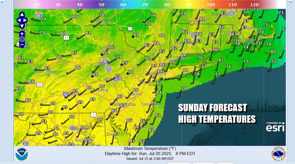
There may be more cloud cover around than sun for Sunday but highs will reach the low and middle 80s before the front passes. Once that front goes by we are going to see lower humidity and sunshine for Monday and Tuesday and we expect the dry air to last into early Wednesday before we see humidity levels head higher for the second half of next week. Much if not all of next week could also wind up being on the dry side with little if any shower or thunderstorm activity.
BE SURE TO DOWNLOAD THE FREE METEOROLOGIST JOE CIOFFI WEATHER APP &
ANGRY BEN’S FREE WEATHER APP “THE ANGRY WEATHERMAN!
MANY THANKS TO TROPICAL TIDBITS FOR THE USE OF MAPS
Please note that with regards to any severe weather, tropical storms, or hurricanes, should a storm be threatening, please consult your local National Weather Service office or your local government officials about what action you should be taking to protect life and property.