Winter Weather Pattern Continues Volatile

There is no mistaking the signature of this winter. The Winter Weather Pattern Continues Volatile and will remains so in the long range. We are going to hit another extreme this weekend with a brutal arctic air mass dropping into the northeast with record breaking cold. Temperatures over a large area are going to go below zero. The arctic air arrives Saturday and then moves out on Monday. From there we are going to see a precipitation event for Tuesday into Wednesday. The overall flavor from the JOESTRADAMUS point of view is that over the next 2 weeks we are going to see another pattern realignment for a short time, followed by another return to similar upper air conditions we have seen over the last few weeks.
Winter Weather Pattern Continues Volatile GFS EUROPEAN COMPARISON
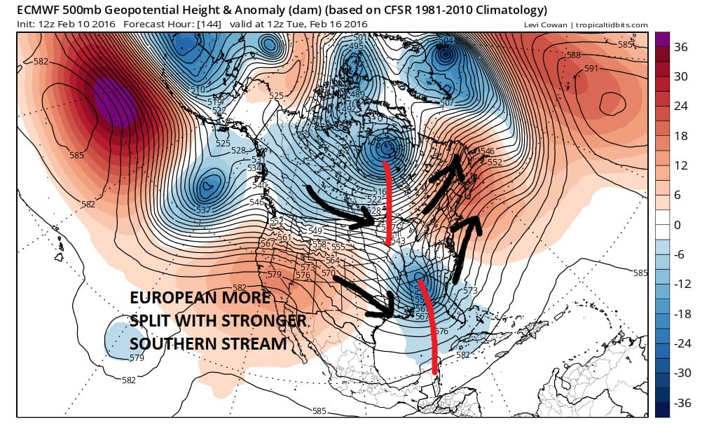
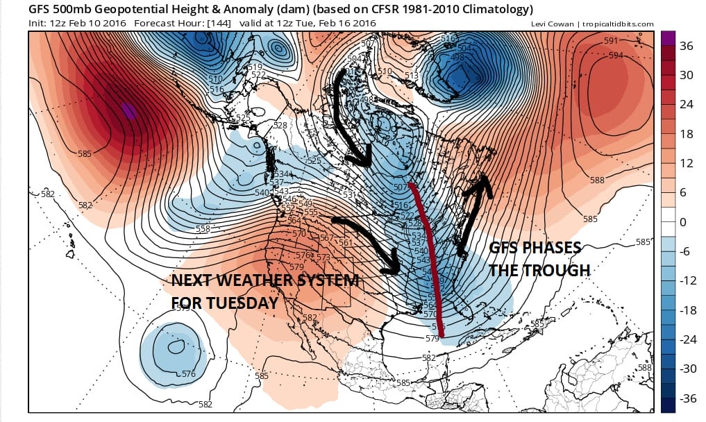
With regards to early next week the GFS & European have different views. The European has a stronger southern stream and the northern jet flattens and pulls up a bit. This is a warmer solution for early next week and it is entirely possible that when precipitation arrives Tuesday we will already be back to 40 degrees and raining. On the other side is the GFS which has a more dominant northern feature that phases with a weaker southern stream. This is a colder and less developed look for early next opening the door to other possibilities especially inland. I’m not sure how this will be resolved though the pattern has been for active southern stream systems which would favor the European. The model however is not exactly hitting home runs lately in the short term so we will hold back on this until we get into a closer range.
Winter Weather Pattern Continues Volatile GFS EUROPEAN VIEW DAY 10

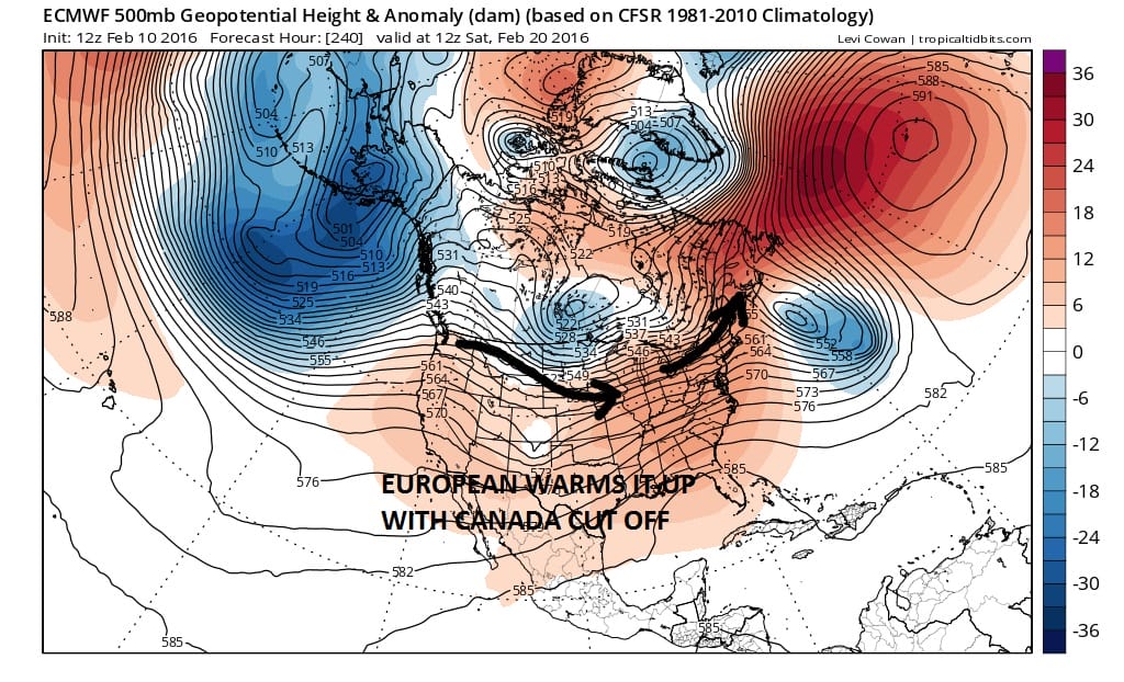
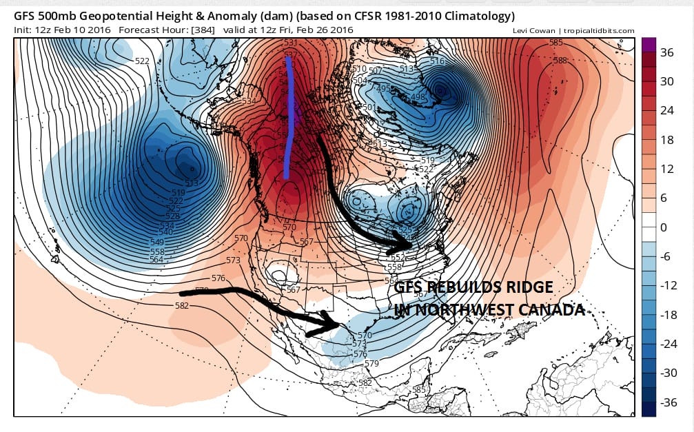
The weather models diverge a bit around day 10 with the European showing a relaxed west to east pattern across the United States while the GFS maintains some ridging in the northwest along with a weak but visible polar flow from Canada. The European model suggests milder than normal temps for sure while the GFS less so. I think the idea that the pattern relaxes a bit makes sense but the issue of that western ridge is important to determine magnitude. Beyond day 10 the GFS amplifies the northwest ridge again which implies a return to an active colder pattern.
Winter Weather Pattern Continues Volatile GFS VIEW DAY 16
I think the bottom line is that the winter volatility continues. I would not be surprised if after next week we flip back to a very active pattern. I think also that more surprises are in store for us as the season enters the home stretch over the next 4 or 5 weeks. There is nothing out there to me that indicates otherwise. The volatility has made this winter extremely unusual. We bounce from extreme to extreme. Until we see some signs of that changing, we continue to view this as the trend is your friend.
NATIONAL WEATHER SERVICE SNOW FORECASTS
LATEST JOESTRADAMUS ON THE LONG RANGE
Weather App

Winter is here! Don’t be without Meteorologist Joe Cioffi’s weather app. It is a complete weather app to suit your forecast needs. All the weather information you need is right on your phone. Android or I-phone, use it to keep track of all the latest weather information and forecasts. This weather app is also free of advertising so you don’t have to worry about security issues with your device. An accurate forecast and no worries that your device is being compromised.
Use it in conjunction with my website and my facebook and twitterand you have complete weather coverage of all the latest weather and the long range outlook. The website has been redone and upgraded. Its easy to use and everything is archived so you can see how well Joe does or doesn’t do when it comes to forecasts and outlooks.
Just click on the google play button or the apple store button on the sidebar for my app which is onMy Weather Concierge. Download the app for free. Subscribe to my forecasts on an ad free environment for just 99 cents a month.
Get my forecasts in the palm of your hand for less than the cost of a cup of Joe!
![]()