Winter Weather Advisory Snow Forecast Amounts Raised 04022018
Winter Weather Advisory Snow Forecast Amounts Raised 04022018
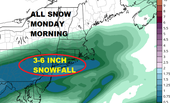
Afternoon weather models continue to hold firm with a resoundly bullish outcome for snow on Monday morning. This fast moving wave of low pressure will gear up as it approaches the coast. The NAM model argues for a solid 3 to 6 inch slushy snowfall beginning after midnight and ending before mid morning across much of the area.
NAM PRECIPITATION FORECAST MONDAY MORNING
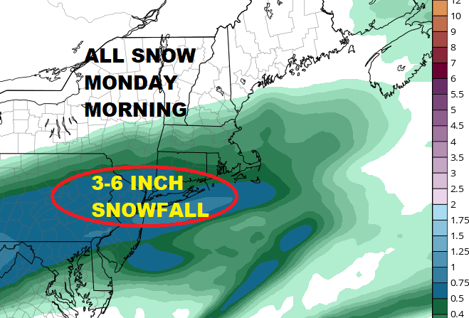
NAM model as well as others are showing a 1/2 inch to almost an inch of liquid falling in a very short period of time. Taking a conservative approach here and allowing for some melting and the impacts of the sun after 8am argues for a 3 to 6 inch accumulation with the possibility of an upside surprise. The main area of accumulation will occur between Route 195 in New Jersey northward to along and south of Route 84. Long Island and Northern New Jersey are probably the areas that have that chance for an upside surprise especially away from urban centers. NYC will likely see snow toward the lower end of the range but areas away from midtown might surprise as well. Weather conditions will likely improve during the afternoon. Tuesday brings the next storm system and rain developing later in the day.

GET JOE A CIGAR SO HE CAN RELAX!
NEW YORK CITY AND VICINITY SNOW

NEW YORK CITY & VICINITY ICE

NEW JERSEY SE PA & VICINITY ICE
NEW JERSEY & PARTS OF NE PA

SOUTHERN AND SOUTHEAST NEW ENGLAND

NORTHERN NEW ENGLAND

WESTERN NEW ENGLAND

MIDDLE AND UPPER HUDSON VALLEY

CENTRAL NEW YORK & NE PA

WESTERN NEW YORK

CENTRAL & SOUTH CENTRAL PA

VIRGINIA & MARYLAND

DAILY NORTHEAST SNOWFALL

Please be advised that these are National Weather Service Forecast Maps and they auto update. Each office may update at different times and some offices are slower to update then others. Maps are usually updated before 5am and & 5pm however they may be updated at other times depending on forecast conditions. These are not my forecasts. My forecasts can be found on the JOE’S SNOWFORECAST PAGE. Individual forecasts for specific areas may also be found when conditions warrant on the my area forecasts. Those can be found on the website menu. Click on forecasts and then select your specific area.