Winter Storm Watches Inland Mainly Along & North of Interstate 84 For Tuesday
Ahead of a storm system moving across the Gulf States, we have Winter Storm Watches and Winter Weather Advisories posted for may areas inland in Upstate New York, Northwest New Jersey, the Hudson Valley north of Route 84 as well as Northwest Connecticut. We also have watches up for Northeast Pennsylvania and advisories for much of the rest of the state for Tuesday.
Weather today is quiet and calm with sunshine for the most part though we will start to see high clouds increase from the west and southwest later today. Most high temperatures will reach the upper 30s to a few lower 40s. High pressure to the northeast will move east and begin to weaken as our storm system forms in the Gulf States and then turns up the East Coast for Tuesday.
SATELLITE WITH LIGHTNING STRIKES
WEATHER RADAR
This storm system will be moving along so expect it to last between 8 and 10 hours from start to finish so that limits the upside. Expect most areas in Eastern Pennsylvania to Southern New England to start snowing between 4am and 7am. It will end in Eastern Pennsylvania around 1-2pm and near the coast probably closer to 4 or 5 pm. Snow accumulations will vary ranging from little along the coast to 4 to 8 inches in a swath across Northeast Pennsylvania through the Middle Hudson Valley and into Central New England.
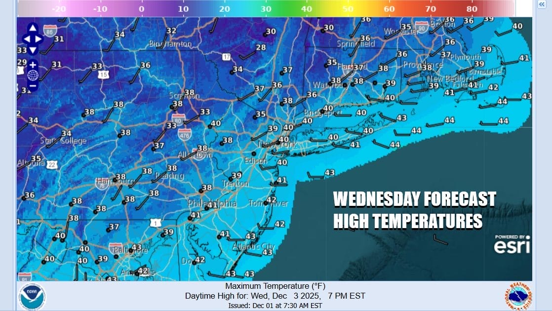
Weather conditions will improve Tuesday night as skies clear and by Wednesday morning, lows will be mostly in the 20s to around 30 degrees. Wednesday should be a nice day but a cold day with sunshine mixing with some patchy clouds from time to time. Most highs Wednesday afternoon will be in the upper 30s & lower 40s.
A cold front will approach from the northwest Thursday and pass through with nothing more than a few clouds. However behind the front will be a shot of very cold air. In fact it will be the coldest air of the season so far and by Friday morning, most areas will be down in the teens for lows and may areas Friday will not get out of the 20s for daytime highs. Updates on the developing snow issues for Tuesday including my early call snow forecasts are available on my subscription platform on Patreon.
BE SURE TO DOWNLOAD THE FREE METEOROLOGIST JOE CIOFFI WEATHER APP &
ANGRY BEN’S FREE WEATHER APP “THE ANGRY WEATHERMAN!
MANY THANKS TO TROPICAL TIDBITS FOR THE USE OF MAPS
Please note that with regards to any severe weather, tropical storms, or hurricanes, should a storm be threatening, please consult your local National Weather Service office or your local government officials about what action you should be taking to protect life and property.