Winter Storm Watch Saturday into Sunday Inland Mid Atlantic & Northeast
Snow Inland Rain Coast

Winter Storm Watch Saturday into Sunday
Inland Mid Atlantic & Northeast, Snow Inland Rain Coast

Winter Storm Watches are posted from the Appalachians northeast across Central and Northeast Pennsylvania to the Catksills and Hudson Valley. Watches extend northward into Upstate NY and eastward across Southern and Southeastern New England. Immediate coastal areas from Massachusetts to Long Island are not in the winter storm watch zone. We may see winter weather advisories go up as well as winter storm warnings probably overnight or certainly by Saturday morning.
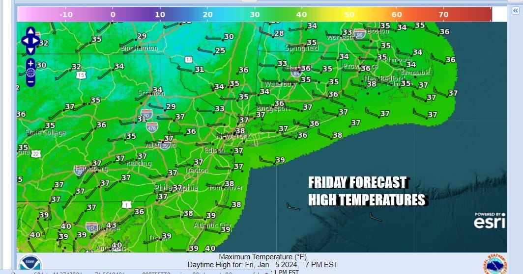
There are no issues for today as we have a high building into Eastern Canada and New England today into Saturday morning and that will filter some cold air southward. It is not a what I would call a quality cold air mass but it is cold enough for inland areas to set up for snow over the weekend. Today will be a day of mostly to partly sunny skies as some clouds might pass through from time to time. Most highs today will be in the mid to upper 30s and we will drop to the 20s tonight. Warmer urban area will likely bottom closer to 30 or so. There a few light snow showers on the radar in parts of Upstate NY but that won’t amount to much there and those snow showers should gradually disappear as the day wears on.
SATELLITE WITH LIGHTNING STRIKES

WEATHER RADAR

Moving on into Saturday we will see clouds increase all day with highs in the 30s. Low pressure will move across the Gulf States today and tonight and spread rain eastward into the Southeast US and then precipitation moves northward Saturday. Snow will break out across Pennsylvania and Northern New Jersey late afternoon Saturday and then spread into New England Saturday night.

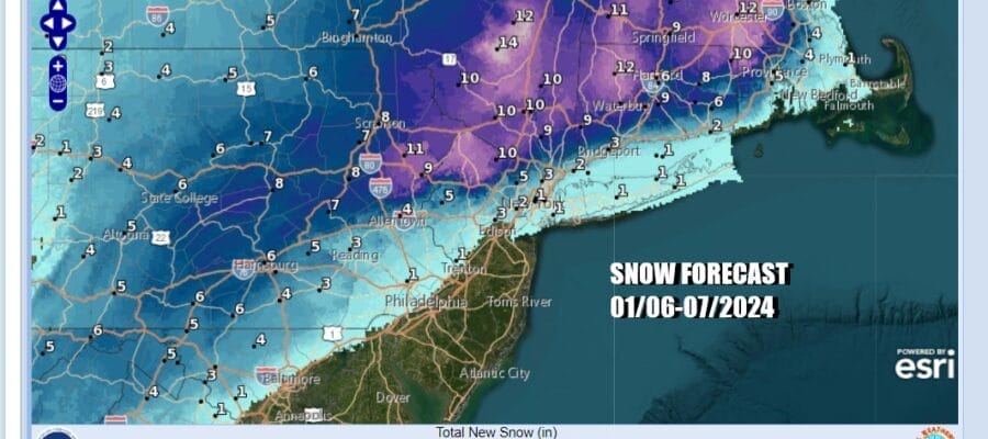
The low track is just far enough north to change the snow to rain at the coast and for some areas it may just be mostly rain from Coastal and Southern New Jersey to Long Island Saturday night while just inland north and west of the big cities we will see snow with accumulations increasing as you go north and northwestard into New Jersey and the Hudson Valley. For areas along and north of Route 84 it is all snow and some mixing could occur southward to Route 287 in Westchester County and Northern New Jersey.
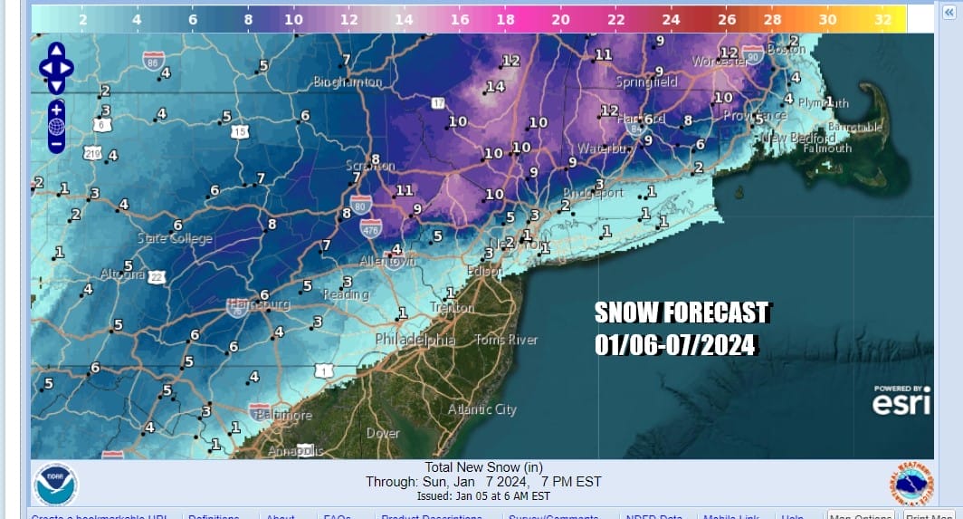
During Sunday as the offshore low strengthens, it could change rain to snow along the coast before it ends while snow will gradually come to an end from west to east during Sunday though it may take awhile as we have to wait for the low to pull away as well as the upper trough to pull away. Inland accumulations of 6 inches or more are possible in the Winter Storm Watch areas and the heaviest snows will fall. 8 to 12 inches area possible mainly along and north of the I-84 corridor. Temperatures Sunday will be in the 30s. Winds along the coast will be increasing to 20 to 35 mph or higher and there is the possibility of some coastal flooding.
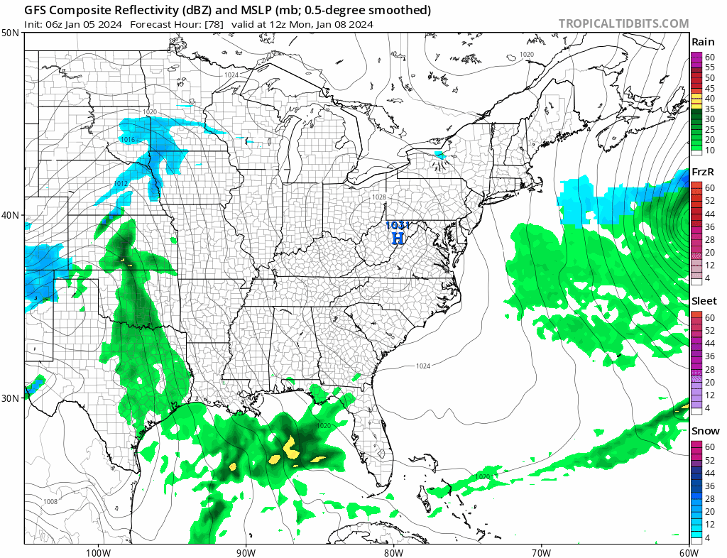
Right on the heels of this storm is another stronger storm that will be coming out of the Southern Plains and heading to Western NY and Western Pennsylvania. This is going to be a major storm system that will bring strong winds, heavy rains and coastal flooding late Tuesday into Wednesday morning. This storm has the potential to produce another 2 inches or so of rain as well as winds gusting over 50 mph. This will wash away most of the snow inland and that could create flooding issues when combined with the expected heavy rain. We will get more specific with this once this weekend storm has finished its work.
BE SURE TO DOWNLOAD THE FREE METEOROLOGIST JOE CIOFFI WEATHER APP &
ANGRY BEN’S FREE WEATHER APP “THE ANGRY WEATHERMAN!
MANY THANKS TO TROPICAL TIDBITS FOR THE USE OF MAPS
Please note that with regards to any severe weather, tropical storms, or hurricanes, should a storm be threatening, please consult your local National Weather Service office or your local government officials about what action you should be taking to protect life and property.
(Amazon is an affilate of Meteorologist Joe Cioffi & earns commissions on sales.)


