Winter Storm Watch Continues For Much of the Northeast, Colder Air Arriving

Winter Storm Watch Continues For Much of the Northeast, Colder Air Arrriving
After a day of highs in the 60s to lower 70s, and some record highs being hit colder air is moving in tonight under a mainly clear sky and a northwest breeze. Temperatures are falling quickly and by morning we will be in the 20s to around 30 degrees. Clouds however are to the west ahead of a weak system running out ahead of our main player which will come Thursday night and Friday. Look for clouds to move in quickly during Thursday and coupled with a northerly wind, temperatures will likely go no higher than the low to middle 30s.
SATELLITE

WEATHER RADAR

Weather conditions will deteriorate Thursday night as low pressure heads up the west side of the Appalachians to Southwest Pennsylvania while a second low tries to form off the Delaware/New Jersey coast. A cold high sits in eastern Canada holding cold air in, at least for awhile as the precipitation breaks out across Pennsylvania and New Jersey Thursday night.

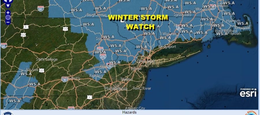
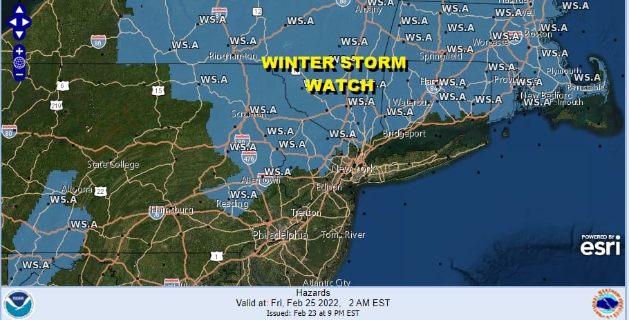
Between 7pm Thursday and 1am Friday, freezing rain sleet and snow will break out across Pennsylvania to Northern Maryland with snow in Northern New Jersey, the Hudson Valley to NYC, Long Island and Western Connecticut and by 4am it will reach southeastern New England. Winter Storm Watches are up for much of the Northeast except for near coastal areas. Thursday morning I would expect to see Winter Storm Warnings to be issued for much of the watch area while surrounding areas in Northern New Jersey. Long Island and Coastal Connecticut to see Winter Weather Advisories go up.
The difficult part of this forecast is the change over to sleet freezing rain and rain (depending upon location) and the timing. The rain ice line will come to a grinding halt northward just to the north of NYC and Long Island Friday morning. There could be a quick couple of inches of snow and sleet south of that line and then it goes to freezing rain or just rain near the coast. Inland however it is a different story as there could be a prolonged period of sleet and freezing rain for Northeastern Pennsylvania and Northern New Jersey to the Hudson Valley north of Route 287 and into Connecticut north of I-95.

There weren’t many changes to the latest National Weather Service snow forecast numbers. Some were tweaked a little higher and some lower. I suspect we might see the coastal numbers nudged up slightly tomorrow morning and inland numbers will be at least the same if not a shade higher. The short range models like the NAM have been on the warm side while the global models like the GFS and European were a little colder. I suspect the answer will be somewhere in between.
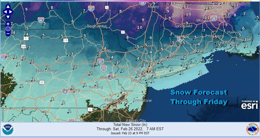
Where we see a change to sleet and freezing rain, there will be ice accretion of a tenth to a quarter of an inch. The freezing rain part of this forecast is difficult since we won’t know to what extent the cold air will hang on. It will be stubborn and this storm system doesn’t have enough strength to dislodge the cold air. Ice accretion could occur even near coastal areas of Southern New England and Long Island where temperatures will be hovering around 32 degrees.

Inland areas in Northern New Jersey and the Hudson Valley however will see temperatures that may not get out of the 20s and the icing there could be more significant. Ice accretion numbers have been raised a bit this evening and they could get nudged up even further on Thursday. This is basically a midnight to noon event for most. Precipition could last through the afternoon though in areas to the east over Eastern Long Island and Connecticut and into Southeastern New England where the rain snow line will be very stubborn to move northward. Weather conditions improve Friday night into Saturday but it will be cold with highs into the 30s Saturday. Sunday we have a sharp upper trough and a cold front approaching and that could put us in line for some snow showers or perhaps, a heavier snow squall is possible. More on that after this storm system moves through.
BE SURE TO DOWNLOAD THE FREE METEOROLOGIST JOE CIOFFI WEATHER APP &
ANGRY BEN’S FREE WEATHER APP “THE ANGRY WEATHERMAN!
MANY THANKS TO TROPICAL TIDBITS & F5 WEATHER FOR THE USE OF MAPS
Please note that with regards to any severe weather, tropical storms, or hurricanes, should a storm be threatening, please consult your local National Weather Service office or your local government officials about what action you should be taking to protect life and property.


